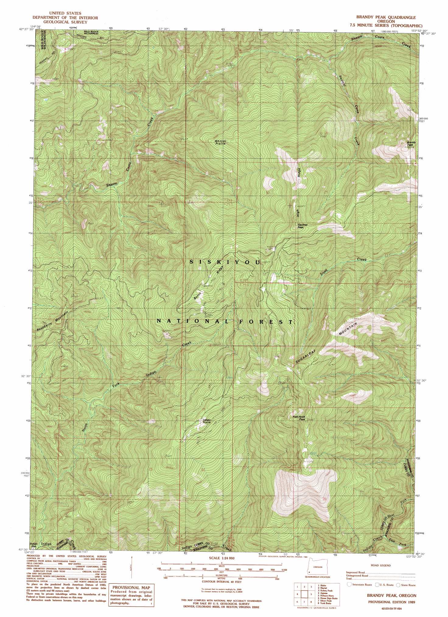
Brandy Peak Topo Map Oregon
To zoom in, hover over the map of Brandy Peak
USGS Topo Quad 42123e8 - 1:24,000 scale
| Topo Map Name: | Brandy Peak |
| USGS Topo Quad ID: | 42123e8 |
| Print Size: | ca. 21 1/4" wide x 27" high |
| Southeast Coordinates: | 42.5° N latitude / 123.875° W longitude |
| Map Center Coordinates: | 42.5625° N latitude / 123.9375° W longitude |
| U.S. State: | OR |
| Filename: | o42123e8.jpg |
| Download Map JPG Image: | Brandy Peak topo map 1:24,000 scale |
| Map Type: | Topographic |
| Topo Series: | 7.5´ |
| Map Scale: | 1:24,000 |
| Source of Map Images: | United States Geological Survey (USGS) |
| Alternate Map Versions: |
Brandy Peak OR 1989, updated 1989 Download PDF Buy paper map Brandy Peak OR 1998, updated 2001 Download PDF Buy paper map Brandy Peak OR 2011 Download PDF Buy paper map Brandy Peak OR 2014 Download PDF Buy paper map |
| FStopo: | US Forest Service topo Brandy Peak is available: Download FStopo PDF Download FStopo TIF |
1:24,000 Topo Quads surrounding Brandy Peak
Barklow Mountain |
China Flat |
Eden Ridge Valley |
Mount Bolivar |
Dutchman Butte |
Ophir Mountain |
Illahe |
Marial |
Kelsey Peak |
Bunker Creek |
Soldier Camp Mountain |
Agness |
Brandy Peak |
Hobson Horn |
Mount Peavine |
Quosatana Butte |
Horse Sign Butte |
Silver Peak |
York Butte |
Chrome Ridge |
Collier Butte |
Big Craggies |
Tincup Peak |
Pearsoll Peak |
Eight Dollar Mountain |
> Back to 42123e1 at 1:100,000 scale
> Back to 42122a1 at 1:250,000 scale
> Back to U.S. Topo Maps home
Brandy Peak topo map: Gazetteer
Brandy Peak: Flats
Indigo Prairie elevation 1096m 3595′Whitten Prairie elevation 961m 3152′
Brandy Peak: Post Offices
Ekoms Post Office (historical) elevation 398m 1305′Brandy Peak: Ridges
Burnt Ridge elevation 1264m 4146′Brandy Peak: Streams
East Fork Indigo Creek elevation 294m 964′Fish Hook Creek elevation 179m 587′
North Fork Indigo Creek elevation 125m 410′
Squirrel Camp Creek elevation 578m 1896′
West Fork Indigo Creek elevation 308m 1010′
Brandy Peak: Summits
Brandy Peak elevation 1574m 5164′Fish Hook Peak elevation 1518m 4980′
Squirrel Peak elevation 1426m 4678′
Sugarloaf Mountain elevation 1517m 4977′
Brandy Peak: Trails
Bear Camp Trail elevation 1349m 4425′Brandy Peak digital topo map on disk
Buy this Brandy Peak topo map showing relief, roads, GPS coordinates and other geographical features, as a high-resolution digital map file on DVD: