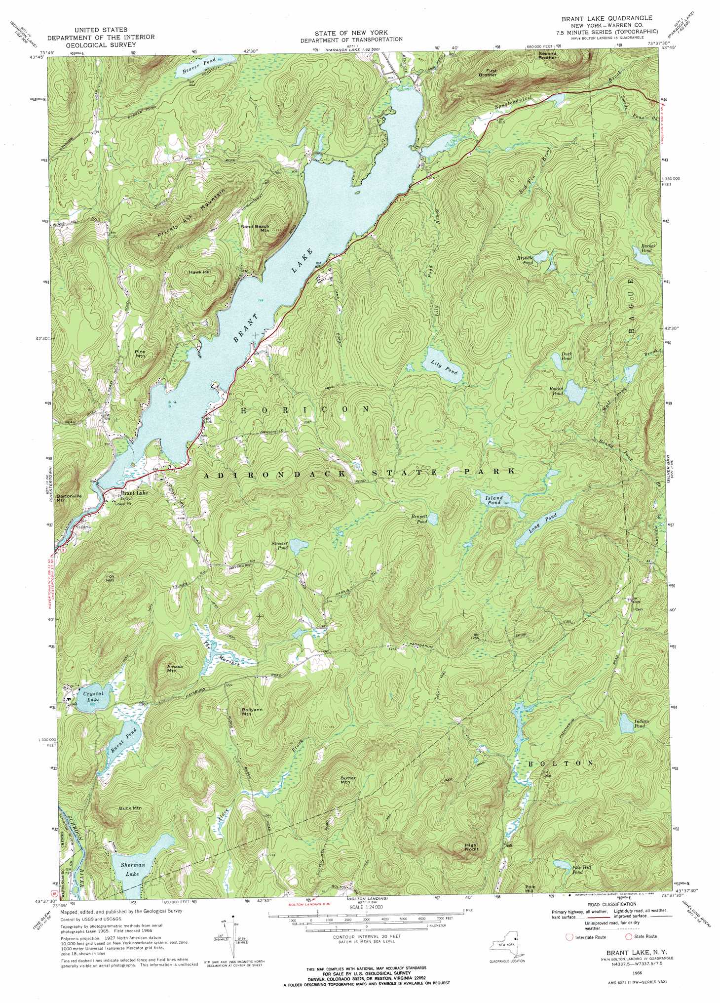
Brant Lake Topo Map New York
To zoom in, hover over the map of Brant Lake
USGS Topo Quad 43073f6 - 1:24,000 scale
| Topo Map Name: | Brant Lake |
| USGS Topo Quad ID: | 43073f6 |
| Print Size: | ca. 21 1/4" wide x 27" high |
| Southeast Coordinates: | 43.625° N latitude / 73.625° W longitude |
| Map Center Coordinates: | 43.6875° N latitude / 73.6875° W longitude |
| U.S. State: | NY |
| Filename: | o43073f6.jpg |
| Download Map JPG Image: | Brant Lake topo map 1:24,000 scale |
| Map Type: | Topographic |
| Topo Series: | 7.5´ |
| Map Scale: | 1:24,000 |
| Source of Map Images: | United States Geological Survey (USGS) |
| Alternate Map Versions: |
Brant Lake NY 1966, updated 1969 Download PDF Buy paper map Brant Lake NY 2010 Download PDF Buy paper map Brant Lake NY 2013 Download PDF Buy paper map Brant Lake NY 2016 Download PDF Buy paper map |
1:24,000 Topo Quads surrounding Brant Lake
Blue Ridge |
Paradox Lake |
Eagle Lake |
Crown Point |
|
Schroon Lake |
Pharaoh Mountain |
Graphite |
Ticonderoga |
|
North Creek |
Chestertown |
Brant Lake |
Silver Bay |
Putnam |
Johnsburg |
The Glen |
Bolton Landing |
Shelving Rock |
Whitehall |
Stony Creek |
Warrensburg |
Lake George |
Putnam Mountain |
Fort Ann |
> Back to 43073e1 at 1:100,000 scale
> Back to 43072a1 at 1:250,000 scale
> Back to U.S. Topo Maps home
Brant Lake topo map: Gazetteer
Brant Lake: Lakes
Beaver Pond elevation 292m 958′Bennett Pond elevation 405m 1328′
Brant Lake elevation 243m 797′
Brindle Pond elevation 335m 1099′
Burnt Pond elevation 289m 948′
Crystal Lake elevation 290m 951′
Duck Pond elevation 387m 1269′
Indian Pond elevation 356m 1167′
Island Pond elevation 406m 1332′
Lily Pond elevation 363m 1190′
Long Pond elevation 399m 1309′
Pole Hill Pond elevation 333m 1092′
Racket Pond elevation 406m 1332′
Round Pond elevation 375m 1230′
Sherman Lake elevation 283m 928′
Streeter Pond elevation 406m 1332′
Brant Lake: Populated Places
Brant Lake elevation 242m 793′Brant Lake: Streams
Lily Pond Brook elevation 243m 797′Red Fin Brook elevation 243m 797′
Spuytenduivel Brook elevation 243m 797′
Swede Pond Brook elevation 265m 869′
Wolf Pond Brook elevation 335m 1099′
Brant Lake: Summits
Amasa Mountain elevation 454m 1489′Buck Mountain elevation 410m 1345′
First Brother elevation 508m 1666′
Fox Hill elevation 459m 1505′
Hawk Hill elevation 396m 1299′
High Nopit elevation 508m 1666′
Pine Mountain elevation 399m 1309′
Pollyann Mountain elevation 458m 1502′
Prickly Ash Mountain elevation 499m 1637′
Sand Beach Mountain elevation 422m 1384′
Second Brother elevation 565m 1853′
Sutter Mountain elevation 508m 1666′
Brant Lake: Swamps
The Marsher elevation 339m 1112′Brant Lake digital topo map on disk
Buy this Brant Lake topo map showing relief, roads, GPS coordinates and other geographical features, as a high-resolution digital map file on DVD:
New York, Vermont, Connecticut & Western Massachusetts
Buy digital topo maps: New York, Vermont, Connecticut & Western Massachusetts