Ohmer Mountain Topo Map New York
To zoom in, hover over the map of Ohmer Mountain
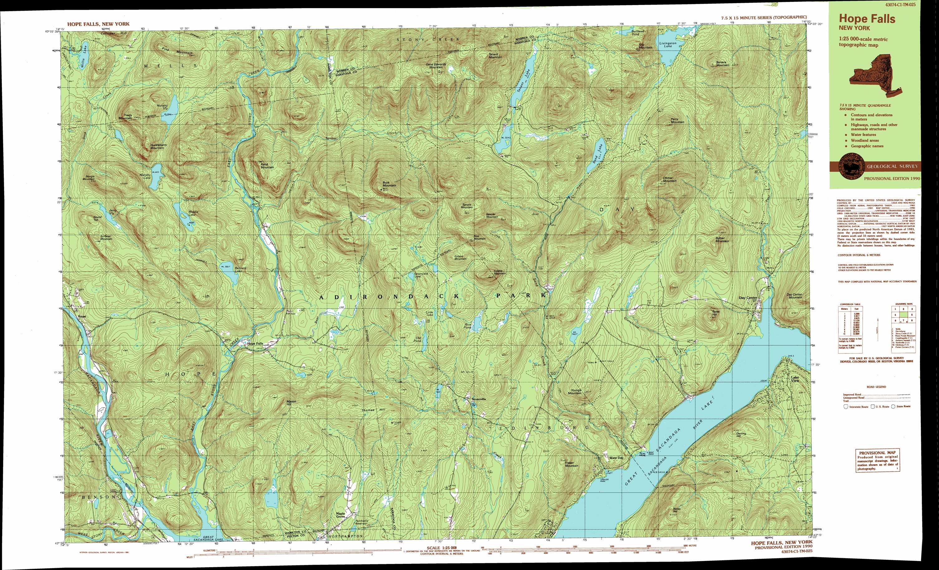
USGS Topo Quad 43074c1 - 1:25,000 scale
| Topo Map Name: | Ohmer Mountain |
| USGS Topo Quad ID: | 43074c1 |
| Print Size: | ca. 39" wide x 24" high |
| Southeast Coordinates: | 43.25° N latitude / 74° W longitude |
| Map Center Coordinates: | 43.3125° N latitude / 74.125° W longitude |
| U.S. State: | NY |
| Filename: | k43074c1.jpg |
| Download Map JPG Image: | Ohmer Mountain topo map 1:25,000 scale |
| Map Type: | Topographic |
| Topo Series: | 7.5´x15´ |
| Map Scale: | 1:25,000 |
| Source of Map Images: | United States Geological Survey (USGS) |
| Alternate Map Versions: |
Hope Falls NY 1990, updated 1990 Download PDF Buy paper map Hope Falls NY 1999, updated 2000 Download PDF Buy paper map |
1:24,000 Topo Quads surrounding Ohmer Mountain
Kunjamuk River |
Bakers Mills |
Johnsburg |
The Glen |
|
Wells |
Harrisburg |
Stony Creek |
Warrensburg |
|
Cathead Mountain |
Ohmer Mountain |
Conklingville |
Lake Luzerne |
|
Jackson Summit |
Northville |
Edinburg |
Porter Corners |
Corinth |
Gloversville |
Broadalbin |
Galway |
Middle Grove |
Saratoga Springs |
> Back to 43074a1 at 1:100,000 scale
> Back to 43074a1 at 1:250,000 scale
> Back to U.S. Topo Maps home
Ohmer Mountain topo map: Gazetteer
Ohmer Mountain: Lakes
Bennett Lake elevation 356m 1167′Bullhead Pond elevation 706m 2316′
Greenfield Lake elevation 573m 1879′
Jerry Vly elevation 367m 1204′
Little Lake elevation 552m 1811′
Livingston Lake elevation 562m 1843′
Middle Lake elevation 454m 1489′
Murphy Lake elevation 449m 1473′
Old Pond elevation 526m 1725′
Rice Pond elevation 496m 1627′
Sand Lake elevation 526m 1725′
Tenant Lake elevation 507m 1663′
Willis Lake elevation 400m 1312′
Ohmer Mountain: Populated Places
Day Center elevation 249m 816′Hope elevation 247m 810′
Lake View elevation 257m 843′
Maple Grove elevation 344m 1128′
Tenantville elevation 437m 1433′
West Day elevation 239m 784′
Ohmer Mountain: Reservoirs
Northville Reservoir elevation 321m 1053′Ohmer Mountain: Streams
Bear Creek elevation 277m 908′East Stony Creek elevation 235m 770′
Glasshouse Creek elevation 246m 807′
Paul Creek elevation 235m 770′
Sand Creek elevation 235m 770′
Tenant Creek elevation 318m 1043′
West Stony Creek elevation 235m 770′
Wilcox Outlet elevation 343m 1125′
Ohmer Mountain: Summits
Bailey Hill elevation 466m 1528′Buck Mountain elevation 814m 2670′
Cobble Mountain elevation 700m 2296′
Colson Mountain elevation 646m 2119′
Deming Hill elevation 418m 1371′
Fraker Mountain elevation 483m 1584′
Freds Mountain elevation 599m 1965′
Gene Edwards Mountain elevation 793m 2601′
Huckleberry Mountain elevation 587m 1925′
Mason Hill elevation 542m 1778′
Ohmer Mountain elevation 784m 2572′
Perry Mountain elevation 708m 2322′
Pine Mountain elevation 566m 1856′
Rand Mountain elevation 490m 1607′
Rice Mountain elevation 749m 2457′
Round Top elevation 439m 1440′
Ryther Mountain elevation 515m 1689′
Sawyer Mountain elevation 736m 2414′
Scribner Mountain elevation 440m 1443′
Seneca Mountain elevation 725m 2378′
Slip Mountain elevation 787m 2582′
Spruce Mountain elevation 793m 2601′
Sturgis Mountain elevation 501m 1643′
Tenant Mountain elevation 841m 2759′
Thomas Hill elevation 523m 1715′
Yates Hill elevation 487m 1597′
Youngs Mountain elevation 497m 1630′
Ohmer Mountain: Swamps
Murphy Vly elevation 434m 1423′Ohmer Mountain digital topo map on disk
Buy this Ohmer Mountain topo map showing relief, roads, GPS coordinates and other geographical features, as a high-resolution digital map file on DVD:
New York, Vermont, Connecticut & Western Massachusetts
Buy digital topo maps: New York, Vermont, Connecticut & Western Massachusetts