Pinconning Topo Map Michigan
To zoom in, hover over the map of Pinconning
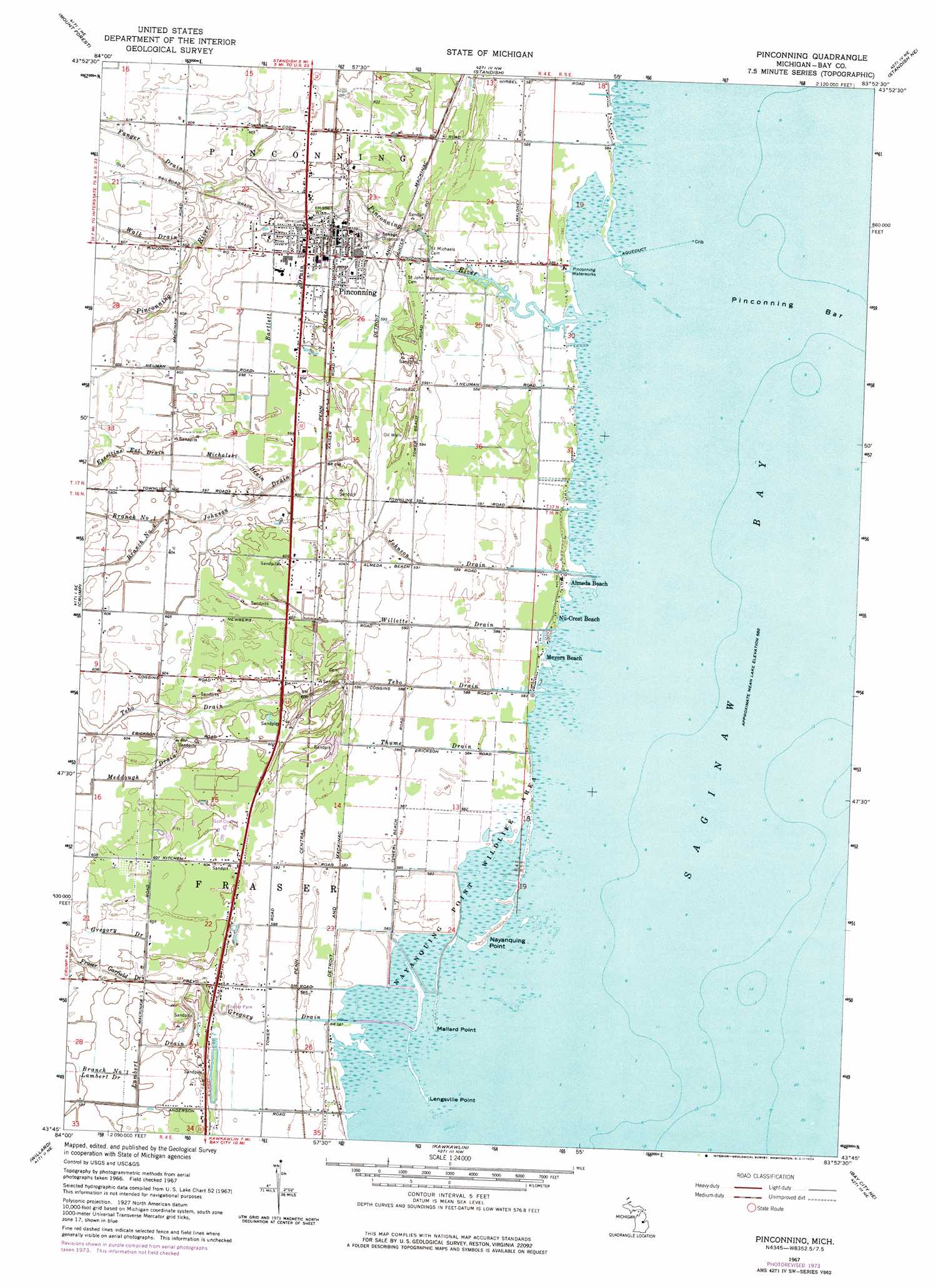
USGS Topo Quad 43083g8 - 1:24,000 scale
| Topo Map Name: | Pinconning |
| USGS Topo Quad ID: | 43083g8 |
| Print Size: | ca. 21 1/4" wide x 27" high |
| Southeast Coordinates: | 43.75° N latitude / 83.875° W longitude |
| Map Center Coordinates: | 43.8125° N latitude / 83.9375° W longitude |
| U.S. State: | MI |
| Filename: | o43083g8.jpg |
| Download Map JPG Image: | Pinconning topo map 1:24,000 scale |
| Map Type: | Topographic |
| Topo Series: | 7.5´ |
| Map Scale: | 1:24,000 |
| Source of Map Images: | United States Geological Survey (USGS) |
| Alternate Map Versions: |
Pinconning MI 1967, updated 1969 Download PDF Buy paper map Pinconning MI 1967, updated 1974 Download PDF Buy paper map Pinconning MI 2011 Download PDF Buy paper map Pinconning MI 2014 Download PDF Buy paper map Pinconning MI 2017 Download PDF Buy paper map |
1:24,000 Topo Quads surrounding Pinconning
Sterling Sw |
Sterling |
Omer Sw |
Omer |
Au Gres |
Bentley |
Mount Forest |
Standish |
Standish Ne |
Au Gres |
Estey |
Crump |
Pinconning |
||
Midland North |
Willard |
Kawkawlin |
Bay City Ne |
|
Midland South |
Auburn |
Bay City |
Essexville |
Quanicassee |
> Back to 43083e1 at 1:100,000 scale
> Back to 43082a1 at 1:250,000 scale
> Back to U.S. Topo Maps home
Pinconning topo map: Gazetteer
Pinconning: Bars
Pinconning Bar elevation 177m 580′Pinconning: Canals
Bartlett Drain elevation 181m 593′Gregory Drain elevation 183m 600′
Pinconning: Capes
Lengsville Point elevation 177m 580′Mallard Point elevation 177m 580′
Nayanquing Point elevation 178m 583′
Pinconning: Parks
Bay County Pinconning Park elevation 178m 583′Nayanquing Point Wildlife Area elevation 177m 580′
Pinconning: Populated Places
Almeda Beach elevation 178m 583′Meyers Beach elevation 178m 583′
Pinconning elevation 182m 597′
Pinconning: Post Offices
Lengsville Post Office (historical) elevation 178m 583′Michie Post Office (historical) elevation 181m 593′
Pinconning Post Office elevation 182m 597′
Tebo Post Office (historical) elevation 183m 600′
Pinconning: Streams
Branch Number One Johnson Drain elevation 182m 597′Branch Number One Lambert Drain elevation 181m 593′
Branch Number Two Johnson Drain elevation 182m 597′
Esseltine Extension Drain elevation 183m 600′
Fanger Drain elevation 180m 590′
Fraser Garfield Drain elevation 178m 583′
Gregory Drain elevation 177m 580′
Johnson Drain elevation 177m 580′
Lambert Drain elevation 178m 583′
Meddough Drain elevation 181m 593′
Michalski Drain elevation 180m 590′
Pinconning River elevation 177m 580′
Tebo Drain elevation 177m 580′
Thume Drain elevation 177m 580′
Walk Drain elevation 181m 593′
Willette Drain elevation 178m 583′
Pinconning digital topo map on disk
Buy this Pinconning topo map showing relief, roads, GPS coordinates and other geographical features, as a high-resolution digital map file on DVD:
 map DVD")