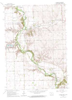
Klondike Topo Map Iowa
To zoom in, hover over the map of Klondike
USGS Topo Quad 43096d5 - 1:24,000 scale
| Topo Map Name: | Klondike |
| USGS Topo Quad ID: | 43096d5 |
| Print Size: | ca. 21 1/4" wide x 27" high |
| Southeast Coordinates: | 43.375° N latitude / 96.5° W longitude |
| Map Center Coordinates: | 43.4375° N latitude / 96.5625° W longitude |
| U.S. States: | IA, SD |
| Filename: | o43096d5.jpg |
| Download Map JPG Image: | Klondike topo map 1:24,000 scale |
| Map Type: | Topographic |
| Topo Series: | 7.5´ |
| Map Scale: | 1:24,000 |
| Source of Map Images: | United States Geological Survey (USGS) |
| Alternate Map Versions: |
Klondike IA 1962, updated 1964 Download PDF Buy paper map Klondike IA 2010 Download PDF Buy paper map Klondike IA 2013 Download PDF Buy paper map Klondike IA 2015 Download PDF Buy paper map |
1:24,000 Topo Quads surrounding Klondike
> Back to 43096a1 at 1:100,000 scale
> Back to 43096a1 at 1:250,000 scale
> Back to U.S. Topo Maps home
Klondike topo map: Gazetteer
Klondike: Bridges
Klondike Bridge elevation 383m 1256′Klondike: Dams
Alvin Dam elevation 399m 1309′Klondike: Forests
Gitchie Manitou State Preserve elevation 395m 1295′Klondike: Parks
Blood Run / Rock Island National Landmark elevation 411m 1348′Gutchie Manitou State Monument Park elevation 393m 1289′
Hidden Bridge Wildlife Area elevation 384m 1259′
Lake Alvin State Recreation Area elevation 399m 1309′
Ninemile Creek State Shooting Area elevation 387m 1269′
Klondike: Populated Places
Granite elevation 399m 1309′Klondike elevation 395m 1295′
Klondike: Post Offices
Gibraltar Post Office (historical) elevation 416m 1364′Granite Post Office (historical) elevation 399m 1309′
Klondike Post Office (historical) elevation 395m 1295′
Upland Post Office (historical) elevation 387m 1269′
Klondike: Reservoirs
Lake Alvin elevation 399m 1309′Klondike: Streams
Blood Run elevation 387m 1269′Blood Run elevation 387m 1269′
Blood Run elevation 387m 1269′
Klondike Creek elevation 378m 1240′
Ninemile Creek elevation 382m 1253′
Spring Creek elevation 385m 1263′
Klondike digital topo map on disk
Buy this Klondike topo map showing relief, roads, GPS coordinates and other geographical features, as a high-resolution digital map file on DVD:
Eastern North Dakota & Eastern South Dakota
Buy digital topo maps: Eastern North Dakota & Eastern South Dakota


