Long Gulch Topo Map Idaho
To zoom in, hover over the map of Long Gulch
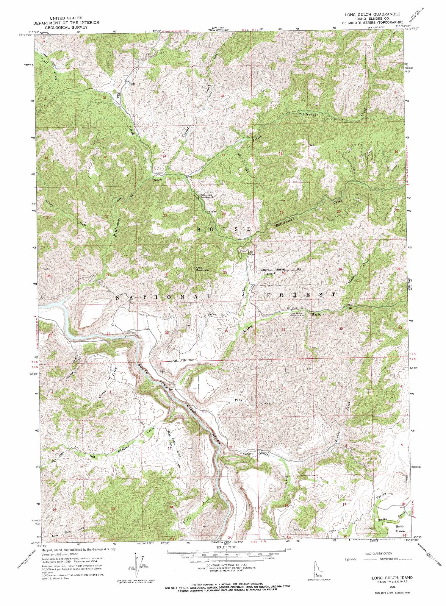
USGS Topo Quad 43115e6 - 1:24,000 scale
| Topo Map Name: | Long Gulch |
| USGS Topo Quad ID: | 43115e6 |
| Print Size: | ca. 21 1/4" wide x 27" high |
| Southeast Coordinates: | 43.5° N latitude / 115.625° W longitude |
| Map Center Coordinates: | 43.5625° N latitude / 115.6875° W longitude |
| U.S. State: | ID |
| Filename: | o43115e6.jpg |
| Download Map JPG Image: | Long Gulch topo map 1:24,000 scale |
| Map Type: | Topographic |
| Topo Series: | 7.5´ |
| Map Scale: | 1:24,000 |
| Source of Map Images: | United States Geological Survey (USGS) |
| Alternate Map Versions: |
Long Gulch ID 1964, updated 1966 Download PDF Buy paper map Long Gulch ID 2011 Download PDF Buy paper map Long Gulch ID 2013 Download PDF Buy paper map |
| FStopo: | US Forest Service topo Long Gulch is available: Download FStopo PDF Download FStopo TIF |
1:24,000 Topo Quads surrounding Long Gulch
Warm Springs Point |
Idaho City |
Rabbit Creek Summit |
Barber Flat |
Grand Mountain |
Dunnigan Creek |
Arrowrock Reservoir Ne |
Twin Springs |
Sheep Creek |
Little Trinity Lake |
Arrowrock Dam |
Grape Mountain |
Long Gulch |
Prairie |
Trinity Mountain |
Mayfield |
Braves Creek |
Danskin Peak |
Cathedral Rocks |
House Mountain |
Mayfield Sw |
Mayfield Se |
Syrup Creek |
Long Tom Reservoir |
Anderson Ranch Dam |
> Back to 43115e1 at 1:100,000 scale
> Back to 43114a1 at 1:250,000 scale
> Back to U.S. Topo Maps home
Long Gulch topo map: Gazetteer
Long Gulch: Benches
Lower Bench elevation 1151m 3776′Long Gulch: Streams
Big Fiddler Creek elevation 995m 3264′Buffalo Creek elevation 1028m 3372′
Chicken Creek elevation 989m 3244′
Corral Creek elevation 1119m 3671′
Crank Creek elevation 988m 3241′
Elk Creek elevation 1107m 3631′
Grape Creek elevation 1032m 3385′
Graves Creek elevation 1167m 3828′
Jackass Creek elevation 1228m 4028′
Little Rattlesnake Creek elevation 1130m 3707′
Pony Creek elevation 1001m 3284′
Rattlesnake Creek elevation 988m 3241′
Smith Creek elevation 1018m 3339′
Spring Creek elevation 1392m 4566′
Timber Creek elevation 1315m 4314′
Wood Cabin Creek elevation 1143m 3750′
Long Gulch: Summits
Flatiron Mountain elevation 1253m 4110′Krall Mountain elevation 1609m 5278′
Long Gulch: Valleys
Long Gulch elevation 1123m 3684′Long Gulch digital topo map on disk
Buy this Long Gulch topo map showing relief, roads, GPS coordinates and other geographical features, as a high-resolution digital map file on DVD: