Sourdough Spring Topo Map Oregon
To zoom in, hover over the map of Sourdough Spring
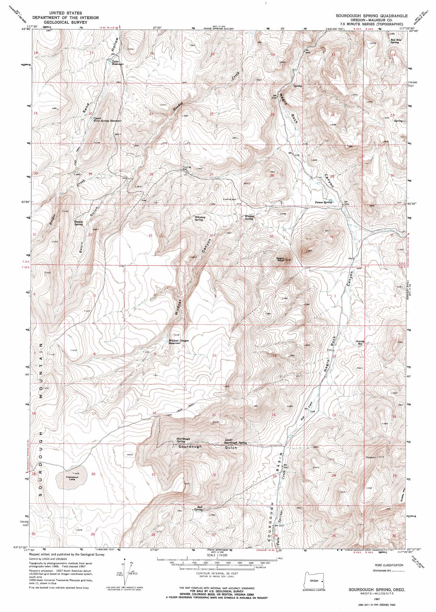
USGS Topo Quad 43117f4 - 1:24,000 scale
| Topo Map Name: | Sourdough Spring |
| USGS Topo Quad ID: | 43117f4 |
| Print Size: | ca. 21 1/4" wide x 27" high |
| Southeast Coordinates: | 43.625° N latitude / 117.375° W longitude |
| Map Center Coordinates: | 43.6875° N latitude / 117.4375° W longitude |
| U.S. State: | OR |
| Filename: | o43117f4.jpg |
| Download Map JPG Image: | Sourdough Spring topo map 1:24,000 scale |
| Map Type: | Topographic |
| Topo Series: | 7.5´ |
| Map Scale: | 1:24,000 |
| Source of Map Images: | United States Geological Survey (USGS) |
| Alternate Map Versions: |
Sourdough Spring OR 1967, updated 1971 Download PDF Buy paper map Sourdough Spring OR 2011 Download PDF Buy paper map Sourdough Spring OR 2014 Download PDF Buy paper map |
1:24,000 Topo Quads surrounding Sourdough Spring
Westfall |
Little Valley |
Vines Hill |
Vale West |
Vale East |
Namorf |
Harper |
Kane Spring Gulch |
Double Mountain |
Mitchell Butte |
Avery Creek |
Keeney Ridge |
Sourdough Spring |
Grassy Mountain |
Owyhee Dam |
Rufino Butte |
Hurley Flat |
Twin Springs |
The Elbow |
Owyhee Ridge |
Copeland Reservoirs |
Wall Rock Springs |
Quartz Mountain Basin |
Pelican Point |
Three Fingers Rock |
> Back to 43117e1 at 1:100,000 scale
> Back to 43116a1 at 1:250,000 scale
> Back to U.S. Topo Maps home
Sourdough Spring topo map: Gazetteer
Sourdough Spring: Basins
Sourdough Basin elevation 1021m 3349′Sourdough Spring: Flats
Rye Field elevation 1026m 3366′Sourdough Spring: Lakes
Freezeout Lake elevation 1347m 4419′Sourdough Spring: Reservoirs
Grassy Reservoir elevation 1031m 3382′Poison Spring Reservoir elevation 980m 3215′
Table Reservoir elevation 1099m 3605′
Upper Kane Spring Reservoir elevation 1149m 3769′
Wildcat Canyon Reservoir elevation 1244m 4081′
Sourdough Spring: Springs
Bull Spring elevation 1134m 3720′Hoodoo Spring elevation 1190m 3904′
Lower Sourdough Spring elevation 1084m 3556′
Poison Spring elevation 981m 3218′
Red Rim Spring elevation 986m 3234′
Sourdough Spring elevation 1150m 3772′
Whiskey Spring elevation 1079m 3540′
Wildcat Spring elevation 1025m 3362′
Sourdough Spring: Summits
Negro Rock elevation 1124m 3687′Sourdough Mountain elevation 1348m 4422′
Sourdough Spring: Valleys
Basin Gulch elevation 1080m 3543′Sourdough Gulch elevation 1037m 3402′
Wildcat Canyon elevation 983m 3225′
Sourdough Spring digital topo map on disk
Buy this Sourdough Spring topo map showing relief, roads, GPS coordinates and other geographical features, as a high-resolution digital map file on DVD: