Owyhee Ridge Topo Map Oregon
To zoom in, hover over the map of Owyhee Ridge
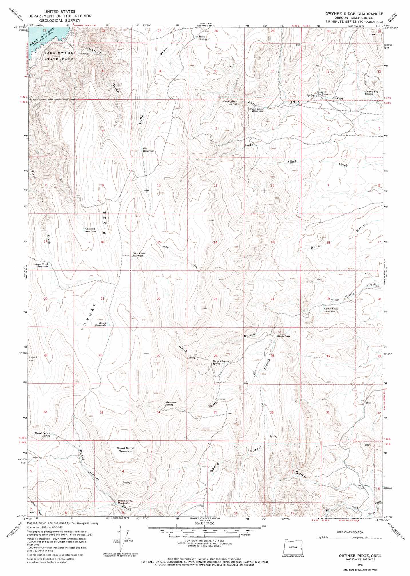
USGS Topo Quad 43117e2 - 1:24,000 scale
| Topo Map Name: | Owyhee Ridge |
| USGS Topo Quad ID: | 43117e2 |
| Print Size: | ca. 21 1/4" wide x 27" high |
| Southeast Coordinates: | 43.5° N latitude / 117.125° W longitude |
| Map Center Coordinates: | 43.5625° N latitude / 117.1875° W longitude |
| U.S. State: | OR |
| Filename: | o43117e2.jpg |
| Download Map JPG Image: | Owyhee Ridge topo map 1:24,000 scale |
| Map Type: | Topographic |
| Topo Series: | 7.5´ |
| Map Scale: | 1:24,000 |
| Source of Map Images: | United States Geological Survey (USGS) |
| Alternate Map Versions: |
Owyhee Ridge OR 1967, updated 1971 Download PDF Buy paper map Owyhee Ridge OR 2011 Download PDF Buy paper map Owyhee Ridge OR 2014 Download PDF Buy paper map |
1:24,000 Topo Quads surrounding Owyhee Ridge
Kane Spring Gulch |
Double Mountain |
Mitchell Butte |
Owyhee |
Parma |
Sourdough Spring |
Grassy Mountain |
Owyhee Dam |
Adrian |
Wilder |
Twin Springs |
The Elbow |
Owyhee Ridge |
Graveyard Point |
Homedale |
Quartz Mountain Basin |
Pelican Point |
Three Fingers Rock |
Pole Creek Top |
Jump Creek Canyon |
Diamond Butte |
Rooster Comb |
Bannock Ridge |
Rockville |
Piute Butte |
> Back to 43117e1 at 1:100,000 scale
> Back to 43116a1 at 1:250,000 scale
> Back to U.S. Topo Maps home
Owyhee Ridge topo map: Gazetteer
Owyhee Ridge: Cliffs
The Tongue elevation 1356m 4448′Owyhee Ridge: Gaps
Devils Gate elevation 987m 3238′Owyhee Ridge: Parks
Lake Owyhee State Park elevation 848m 2782′Owyhee Ridge: Reservoirs
Alkali Draw Reservoir elevation 987m 3238′Bas Reservoir elevation 1287m 4222′
Bench Reservoir elevation 1373m 4504′
Birch Creek Reservoir elevation 1324m 4343′
Board Corral Reservoir elevation 1212m 3976′
Calhoun Reservoir elevation 1322m 4337′
Camp Kettle Reservoir elevation 876m 2874′
Rock Fence Reservoir elevation 1353m 4438′
Stark Reservoir elevation 1142m 3746′
Owyhee Ridge: Springs
Board Corral Spring elevation 1365m 4478′Cabin Springs elevation 912m 2992′
Danny Boy Spring elevation 877m 2877′
Monument Spring elevation 1278m 4192′
North Alkali Spring elevation 1049m 3441′
Three Fingers Spring elevation 1124m 3687′
Owyhee Ridge: Streams
Gordon Creek elevation 814m 2670′North Branch Camp Kettle Creek elevation 872m 2860′
Sage Creek elevation 793m 2601′
South Branch Camp Kettle Creek elevation 872m 2860′
Owyhee Ridge: Summits
Board Corral Mountain elevation 1512m 4960′Owyhee Ridge: Valleys
Gordon Gulch elevation 813m 2667′Owyhee Ridge digital topo map on disk
Buy this Owyhee Ridge topo map showing relief, roads, GPS coordinates and other geographical features, as a high-resolution digital map file on DVD: