Addison Topo Map Maine
To zoom in, hover over the map of Addison
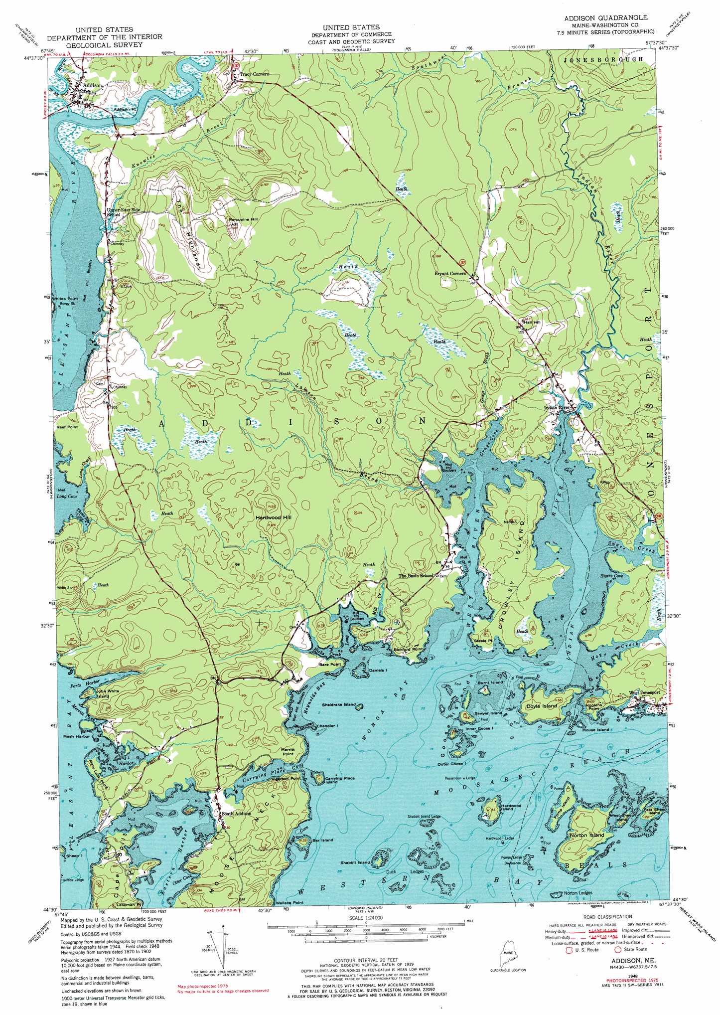
USGS Topo Quad 44067e6 - 1:24,000 scale
| Topo Map Name: | Addison |
| USGS Topo Quad ID: | 44067e6 |
| Print Size: | ca. 21 1/4" wide x 27" high |
| Southeast Coordinates: | 44.5° N latitude / 67.625° W longitude |
| Map Center Coordinates: | 44.5625° N latitude / 67.6875° W longitude |
| U.S. State: | ME |
| Filename: | o44067e6.jpg |
| Download Map JPG Image: | Addison topo map 1:24,000 scale |
| Map Type: | Topographic |
| Topo Series: | 7.5´ |
| Map Scale: | 1:24,000 |
| Source of Map Images: | United States Geological Survey (USGS) |
| Alternate Map Versions: |
Addison ME 1948, updated 1973 Download PDF Buy paper map Addison ME 1948, updated 1978 Download PDF Buy paper map Addison ME 1951, updated 1951 Download PDF Buy paper map Addison ME 2011 Download PDF Buy paper map Addison ME 2014 Download PDF Buy paper map |
1:24,000 Topo Quads surrounding Addison
Northeast Bluff |
Montegail Pond |
Peaked Mountain Pond |
Bog Lake |
Hadley Lake |
Schoodic Lake |
Epping |
Columbia Falls |
Whitneyville |
Machias |
Cherryfield |
Harrington |
Addison |
Jonesport |
Roque Bluffs |
Petit Manan Point |
Bois Bubert |
Drisko Island |
Great Wass Island |
|
> Back to 44067e1 at 1:100,000 scale
> Back to 44066a1 at 1:250,000 scale
> Back to U.S. Topo Maps home
Addison topo map: Gazetteer
Addison: Bars
Duck Ledges elevation 0m 0′Fessenden Ledge elevation 0m 0′
Halftide Ledge elevation 0m 0′
Hardwood Island Ledge elevation 0m 0′
Norton Ledges elevation 0m 0′
Pomps Island Ledge elevation 0m 0′
Shabbit Island Ledge elevation 0m 0′
Addison: Bays
Carrying Place Cove elevation 0m 0′Eastern Harbor elevation 0m 0′
Grays Cove elevation 0m 0′
Kent Cove elevation 0m 0′
Long Cove elevation 0m 0′
Mash Harbor elevation 0m 0′
Merritt Cove elevation 0m 0′
Otter Cove elevation 0m 0′
Ports Harbor elevation 0m 0′
Reynolds Bay elevation 0m 0′
Snare Cove elevation 0m 0′
Three Brooks elevation 0m 0′
Wohoa Bay elevation 0m 0′
Addison: Capes
Addison Point elevation 1m 3′Bare Point elevation 9m 29′
Bickford Point elevation 4m 13′
Cape Split elevation 23m 75′
Hopkins Point elevation 18m 59′
Ingersoll Point elevation 9m 29′
Lakeman Point elevation 0m 0′
Mary Look Point elevation 3m 9′
Merritt Point elevation 8m 26′
Moose Neck elevation 19m 62′
Reef Point elevation 11m 36′
Steele Point elevation 3m 9′
Wallace Point elevation 0m 0′
Whites Point elevation 9m 29′
Addison: Guts
Hopkins Gut elevation 0m 0′Addison: Islands
Bar Island elevation 9m 29′Bungy Rock elevation 0m 0′
Burnt Island elevation 0m 0′
Carrying Place Island elevation 13m 42′
Chandler Island elevation 0m 0′
Crowley Island elevation 9m 29′
Daniels Island elevation 0m 0′
Doyle Island elevation 10m 32′
East Sheep Island elevation 8m 26′
Goose Islands elevation 1m 3′
Hardwood Island elevation 11m 36′
Inner Goose Island elevation 9m 29′
John White Island elevation 8m 26′
Mash Harbor Island elevation 0m 0′
Mouse Island elevation 0m 0′
Norton Island elevation 13m 42′
Outer Goose Island elevation 10m 32′
Pomp Island elevation 0m 0′
Sawyer Island elevation 13m 42′
Shabbit Island elevation 0m 0′
Sheldrake Island elevation 0m 0′
West Sheep Island elevation 3m 9′
Addison: Populated Places
Addison elevation 3m 9′Indian River elevation 3m 9′
South Addison elevation 6m 19′
Addison: Streams
Grays Brook elevation 7m 22′Hay Creek elevation 0m 0′
Hicks Creek elevation 0m 0′
Indian River elevation 0m 0′
Knowles Brook elevation 0m 0′
Lamsen Brook elevation 0m 0′
Long Creek elevation 10m 32′
Long Creek elevation 0m 0′
Mill Creek elevation 0m 0′
Snare Creek elevation 0m 0′
Southwest Branch Indian River elevation 11m 36′
West Branch Pleasant River elevation 1m 3′
West River elevation 0m 0′
Addison: Summits
Hall Hill elevation 50m 164′Hardwood Hill elevation 41m 134′
Porcupine Hill elevation 54m 177′
The Highlands elevation 70m 229′
Addison digital topo map on disk
Buy this Addison topo map showing relief, roads, GPS coordinates and other geographical features, as a high-resolution digital map file on DVD:
Maine, New Hampshire, Rhode Island & Eastern Massachusetts
Buy digital topo maps: Maine, New Hampshire, Rhode Island & Eastern Massachusetts