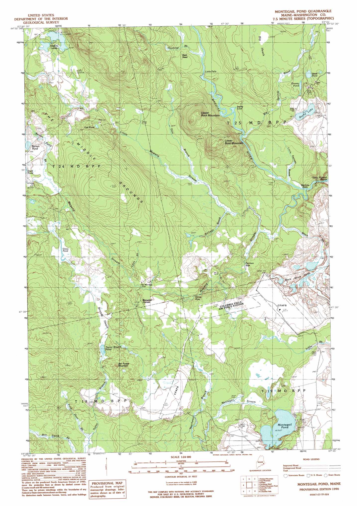
Montegail Pond Topo Map Maine
To zoom in, hover over the map of Montegail Pond
USGS Topo Quad 44067g7 - 1:24,000 scale
| Topo Map Name: | Montegail Pond |
| USGS Topo Quad ID: | 44067g7 |
| Print Size: | ca. 21 1/4" wide x 27" high |
| Southeast Coordinates: | 44.75° N latitude / 67.75° W longitude |
| Map Center Coordinates: | 44.8125° N latitude / 67.8125° W longitude |
| U.S. State: | ME |
| Filename: | o44067g7.jpg |
| Download Map JPG Image: | Montegail Pond topo map 1:24,000 scale |
| Map Type: | Topographic |
| Topo Series: | 7.5´ |
| Map Scale: | 1:24,000 |
| Source of Map Images: | United States Geological Survey (USGS) |
| Alternate Map Versions: |
Montegail Pond ME 1990, updated 1990 Download PDF Buy paper map Montegail Pond ME 2011 Download PDF Buy paper map Montegail Pond ME 2014 Download PDF Buy paper map |
1:24,000 Topo Quads surrounding Montegail Pond
Gassabias Lake |
Fletcher Peak |
Monroe Lake |
Clifford Lake |
Crawford Lake |
Quillpig Mountain |
Peaked Mountain |
Tug Mountain |
Wesley |
Round Lake |
Lead Mountain |
Northeast Bluff |
Montegail Pond |
Peaked Mountain Pond |
Bog Lake |
Tunk Mountain |
Schoodic Lake |
Epping |
Columbia Falls |
Whitneyville |
Tunk Lake |
Cherryfield |
Harrington |
Addison |
Jonesport |
> Back to 44067e1 at 1:100,000 scale
> Back to 44066a1 at 1:250,000 scale
> Back to U.S. Topo Maps home
Montegail Pond topo map: Gazetteer
Montegail Pond: Bays
Ingley Cove elevation 45m 147′Montegail Pond: Falls
Little Falls elevation 45m 147′Montegail Pond: Flats
The Middle Grounds elevation 101m 331′Montegail Pond: Lakes
Barren Pond elevation 78m 255′Black Brook Ponds elevation 56m 183′
Dead Pond elevation 72m 236′
Grass Pond elevation 78m 255′
Grassy Pond elevation 65m 213′
Hadley Lakes elevation 79m 259′
Montegail Pond elevation 64m 209′
Oak Pond elevation 76m 249′
Rocky Lake elevation 64m 209′
Taylor Brook Pond elevation 90m 295′
Montegail Pond: Populated Places
Brewster Corner elevation 74m 242′Montegail Pond: Rapids
Horse Rips elevation 66m 216′Machias Eddy elevation 44m 144′
Penman Rips elevation 45m 147′
Upper Wigwam Rapids elevation 41m 134′
Montegail Pond: Streams
Barren Pond Brook elevation 75m 246′Big Springy Brook elevation 44m 144′
Bill Smith Brook elevation 51m 167′
Billings Brook elevation 47m 154′
Black Brook elevation 45m 147′
East Branch Little Mopang Stream elevation 49m 160′
Fred Dorr Brook elevation 51m 167′
Haunted Brook elevation 48m 157′
Larry Brook elevation 69m 226′
Little Mopang Stream elevation 45m 147′
Little Spring Brook elevation 43m 141′
Montegail Stream elevation 52m 170′
Mopang Stream elevation 45m 147′
Northwest Branch Montegail Stream elevation 57m 187′
Taylor Branch elevation 50m 164′
Montegail Pond: Summits
Bald Head elevation 79m 259′Ben Tucker Mountain elevation 98m 321′
Lower Buck Mountain elevation 123m 403′
Upper Buck Mountain elevation 117m 383′
Montegail Pond: Swamps
Big Heath elevation 69m 226′Brandy Heath elevation 92m 301′
Montegail Pond digital topo map on disk
Buy this Montegail Pond topo map showing relief, roads, GPS coordinates and other geographical features, as a high-resolution digital map file on DVD:
Maine, New Hampshire, Rhode Island & Eastern Massachusetts
Buy digital topo maps: Maine, New Hampshire, Rhode Island & Eastern Massachusetts