Lake Wissota Topo Map Wisconsin
To zoom in, hover over the map of Lake Wissota
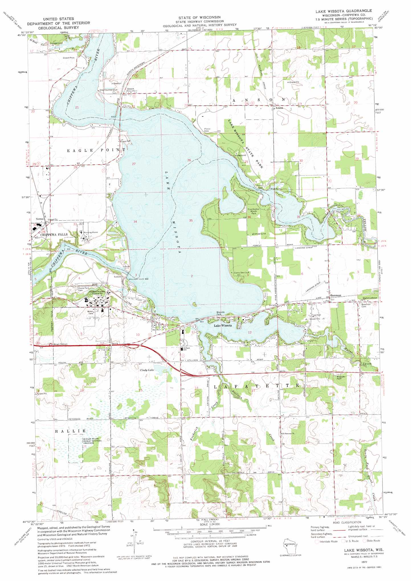
USGS Topo Quad 44091h3 - 1:24,000 scale
| Topo Map Name: | Lake Wissota |
| USGS Topo Quad ID: | 44091h3 |
| Print Size: | ca. 21 1/4" wide x 27" high |
| Southeast Coordinates: | 44.875° N latitude / 91.25° W longitude |
| Map Center Coordinates: | 44.9375° N latitude / 91.3125° W longitude |
| U.S. State: | WI |
| Filename: | o44091h3.jpg |
| Download Map JPG Image: | Lake Wissota topo map 1:24,000 scale |
| Map Type: | Topographic |
| Topo Series: | 7.5´ |
| Map Scale: | 1:24,000 |
| Source of Map Images: | United States Geological Survey (USGS) |
| Alternate Map Versions: |
Lake Wissota WI 1972, updated 1975 Download PDF Buy paper map Lake Wissota WI 2010 Download PDF Buy paper map Lake Wissota WI 2013 Download PDF Buy paper map Lake Wissota WI 2015 Download PDF Buy paper map |
1:24,000 Topo Quads surrounding Lake Wissota
New Auburn |
Marsh-Miller Lake |
Bob Lake |
Cornell |
Holcombe |
Como Creek |
Bloomer |
Jim Falls |
Crescent |
Colburn |
Albertville |
Chippewa Falls |
Lake Wissota |
Cadott |
Boyd |
Eau Claire West |
Eau Claire East |
Fall Creek |
Lake Eau Claire West |
Lake Eau Claire East |
Mondovi Ne |
Cleghorn |
Brackett |
Augusta West |
Augusta East |
> Back to 44091e1 at 1:100,000 scale
> Back to 44090a1 at 1:250,000 scale
> Back to U.S. Topo Maps home
Lake Wissota topo map: Gazetteer
Lake Wissota: Airports
Wissota Airport elevation 285m 935′Lake Wissota: Dams
Wissota WP37 Dam elevation 275m 902′Lake Wissota: Lakes
Cindy Lake elevation 279m 915′Lake Wissota: Parks
Hallie State Public Hunting Grounds elevation 278m 912′Lake Wissota State Park elevation 287m 941′
Pine Harbor Woods Park elevation 287m 941′
Lake Wissota: Populated Places
Anson elevation 289m 948′Bateman elevation 286m 938′
Lake Wissota elevation 281m 921′
Norma elevation 280m 918′
Lake Wissota: Reservoirs
Lake Wissota elevation 271m 889′Lake Wissota 5548 elevation 275m 902′
Lake Wissota: Streams
Frederick Creek elevation 274m 898′Jim Creek elevation 274m 898′
O'Neil Creek elevation 274m 898′
Paint Creek elevation 274m 898′
Stillson Creek elevation 274m 898′
Yellow River elevation 274m 898′
Lake Wissota digital topo map on disk
Buy this Lake Wissota topo map showing relief, roads, GPS coordinates and other geographical features, as a high-resolution digital map file on DVD: