Somerville Flats West Topo Map Wyoming
To zoom in, hover over the map of Somerville Flats West
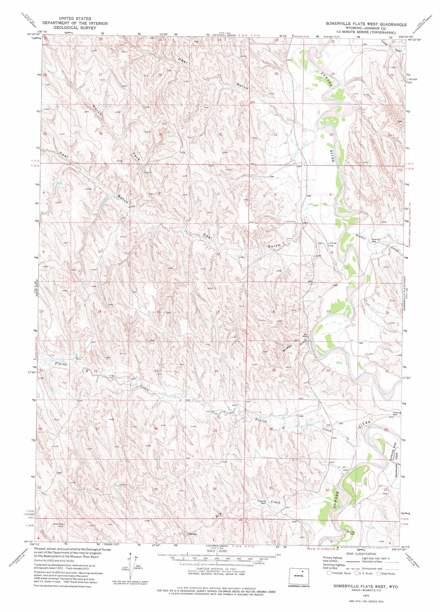
USGS Topo Quad 44106c2 - 1:24,000 scale
| Topo Map Name: | Somerville Flats West |
| USGS Topo Quad ID: | 44106c2 |
| Print Size: | ca. 21 1/4" wide x 27" high |
| Southeast Coordinates: | 44.25° N latitude / 106.125° W longitude |
| Map Center Coordinates: | 44.3125° N latitude / 106.1875° W longitude |
| U.S. State: | WY |
| Filename: | o44106c2.jpg |
| Download Map JPG Image: | Somerville Flats West topo map 1:24,000 scale |
| Map Type: | Topographic |
| Topo Series: | 7.5´ |
| Map Scale: | 1:24,000 |
| Source of Map Images: | United States Geological Survey (USGS) |
| Alternate Map Versions: |
Somerville Flats West WY 1972, updated 1975 Download PDF Buy paper map Somerville Flats West WY 2012 Download PDF Buy paper map Somerville Flats West WY 2015 Download PDF Buy paper map |
1:24,000 Topo Quads surrounding Somerville Flats West
Julio Draw |
Arpan Butte |
Jewell Draw |
Lariat |
Croton |
Fredrick Draw |
Floate Draw |
Mitchell Draw |
Livingston Draw |
Echeta |
Pine Gulch |
Bear Draw |
Somerville Flats West |
Somerville Flats East |
Carr Draw |
Crazy Woman Ranch |
Ploessers Draw |
Juniper Draw |
Laskie Draw |
Morgan Draw |
Brown Ranch |
Boon |
Bowman Flat |
Negro Butte |
Bogie Draw |
> Back to 44106a1 at 1:100,000 scale
> Back to 44106a1 at 1:250,000 scale
> Back to U.S. Topo Maps home
Somerville Flats West topo map: Gazetteer
Somerville Flats West: Dams
Deep Dam elevation 1321m 4333′Government Number 1 Dam elevation 1322m 4337′
Raper Draw Dam elevation 1269m 4163′
Sand Draw Dam elevation 1306m 4284′
Somerville Flats West: Reservoirs
Deep Reservoir elevation 1321m 4333′Government Number 1 Reservoir elevation 1322m 4337′
Raper Draw Reservoir elevation 1269m 4163′
Sand Draw Reservoir elevation 1306m 4284′
Somerville Flats West: Streams
Barber Creek elevation 1175m 3854′Dry Creek elevation 1191m 3907′
Flying E Creek elevation 1186m 3891′
Somerville Flats West: Valleys
Bridge Draw elevation 1177m 3861′Coal Gulch elevation 1197m 3927′
Deer Gulch elevation 1176m 3858′
North Fork Coal Gulch elevation 1233m 4045′
Somerville Draw elevation 1189m 3900′
Somerville Flats West digital topo map on disk
Buy this Somerville Flats West topo map showing relief, roads, GPS coordinates and other geographical features, as a high-resolution digital map file on DVD:
Eastern Wyoming & Western South Dakota
Buy digital topo maps: Eastern Wyoming & Western South Dakota