Flambeau Ridge Topo Map Wisconsin
To zoom in, hover over the map of Flambeau Ridge
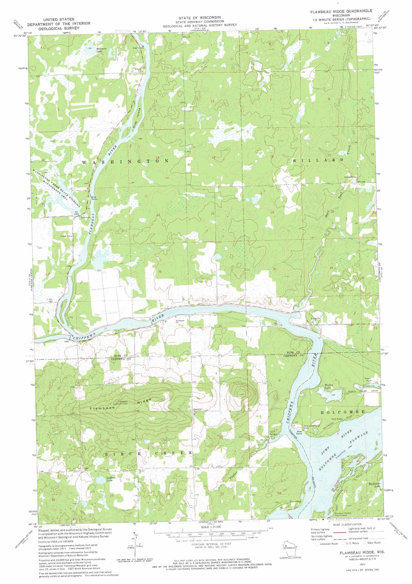
USGS Topo Quad 45091c2 - 1:24,000 scale
| Topo Map Name: | Flambeau Ridge |
| USGS Topo Quad ID: | 45091c2 |
| Print Size: | ca. 21 1/4" wide x 27" high |
| Southeast Coordinates: | 45.25° N latitude / 91.125° W longitude |
| Map Center Coordinates: | 45.3125° N latitude / 91.1875° W longitude |
| U.S. State: | WI |
| Filename: | o45091c2.jpg |
| Download Map JPG Image: | Flambeau Ridge topo map 1:24,000 scale |
| Map Type: | Topographic |
| Topo Series: | 7.5´ |
| Map Scale: | 1:24,000 |
| Source of Map Images: | United States Geological Survey (USGS) |
| Alternate Map Versions: |
Flambeau Ridge WI 1971, updated 1974 Download PDF Buy paper map Flambeau Ridge WI 2010 Download PDF Buy paper map Flambeau Ridge WI 2013 Download PDF Buy paper map Flambeau Ridge WI 2015 Download PDF Buy paper map |
1:24,000 Topo Quads surrounding Flambeau Ridge
Bucks Lake |
Becky Creek |
Crane |
Exeland Se |
Big Falls Dam |
Weyerhauser |
Bruce |
Thornapple |
Ladysmith |
Tony |
Chain Lake |
Fireside Lakes |
Flambeau Ridge |
Ladysmith Se |
Sheldon |
Marsh-Miller Lake |
Bob Lake |
Cornell |
Holcombe |
Ruby |
Bloomer |
Jim Falls |
Crescent |
Colburn |
Huron |
> Back to 45091a1 at 1:100,000 scale
> Back to 45090a1 at 1:250,000 scale
> Back to U.S. Topo Maps home
Flambeau Ridge topo map: Gazetteer
Flambeau Ridge: Dams
Washington Creek Wildlife Area Dam elevation 325m 1066′Flambeau Ridge: Islands
Pine Island elevation 324m 1062′Flambeau Ridge: Lakes
Bollman Lake elevation 330m 1082′LaRose Lake elevation 358m 1174′
Wesley Lake elevation 319m 1046′
Flambeau Ridge: Parks
Plagge Woods State Natural Area elevation 416m 1364′Sportsman Club Park elevation 320m 1049′
Washington Creek State Wildlife Management Area elevation 325m 1066′
Flambeau Ridge: Populated Places
Rivers Edge elevation 329m 1079′Flambeau Ridge: Reservoirs
Washington Creek Flowage elevation 325m 1066′Flambeau Ridge: Ridges
Flambeau Ridge elevation 465m 1525′Flambeau Ridge: Streams
Deer Tail Creek elevation 318m 1043′Flambeau River elevation 318m 1043′
Jump River elevation 318m 1043′
Taylor Creek elevation 318m 1043′
Flambeau Ridge digital topo map on disk
Buy this Flambeau Ridge topo map showing relief, roads, GPS coordinates and other geographical features, as a high-resolution digital map file on DVD: