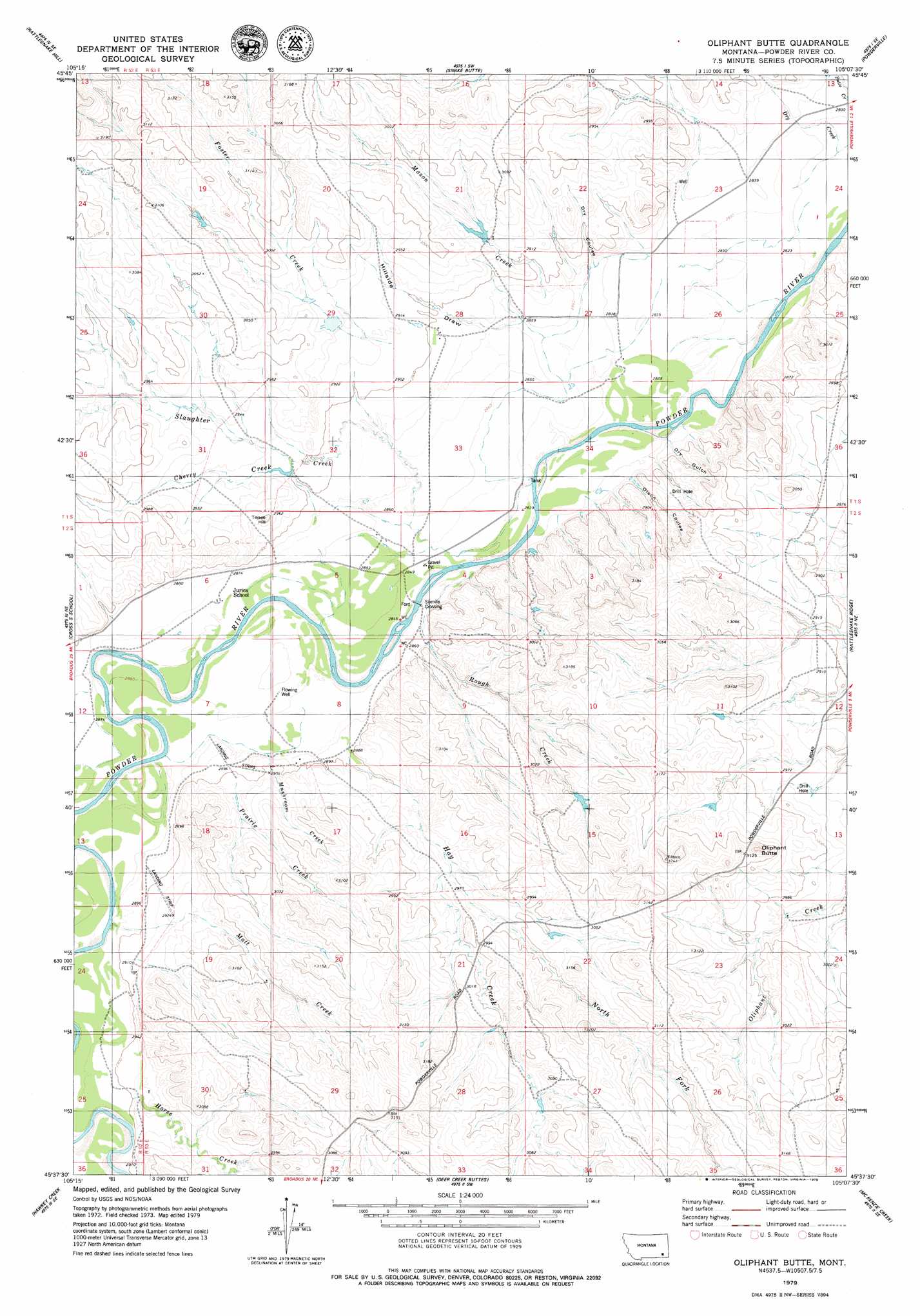
Oliphant Butte Topo Map Montana
To zoom in, hover over the map of Oliphant Butte
USGS Topo Quad 45105f2 - 1:24,000 scale
| Topo Map Name: | Oliphant Butte |
| USGS Topo Quad ID: | 45105f2 |
| Print Size: | ca. 21 1/4" wide x 27" high |
| Southeast Coordinates: | 45.625° N latitude / 105.125° W longitude |
| Map Center Coordinates: | 45.6875° N latitude / 105.1875° W longitude |
| U.S. State: | MT |
| Filename: | o45105f2.jpg |
| Download Map JPG Image: | Oliphant Butte topo map 1:24,000 scale |
| Map Type: | Topographic |
| Topo Series: | 7.5´ |
| Map Scale: | 1:24,000 |
| Source of Map Images: | United States Geological Survey (USGS) |
| Alternate Map Versions: |
Oliphant Butte MT 1979, updated 1979 Download PDF Buy paper map Oliphant Butte MT 2011 Download PDF Buy paper map Oliphant Butte MT 2014 Download PDF Buy paper map |
1:24,000 Topo Quads surrounding Oliphant Butte
Saddle Horse Butte |
Maxwell Butte |
Mills Creek West |
Mills Creek East |
Blacktail Creek Nw |
Witcher Reservoir |
Rattlesnake Hill |
Snake Butte |
Powderville |
Blacktail Creek Sw |
Johnnie Creek |
Cross S School |
Oliphant Butte |
Rattlesnake Ridge |
Davis Creek West |
Moonlight Creek |
Hawkey Creek |
Deer Creek Buttes |
Mckenzie Creek |
Pocochichee Butte |
Broadus |
Monday Creek |
Little Pilgrim Butte |
Lightning Butte |
Pentecost Reservoir |
> Back to 45105e1 at 1:100,000 scale
> Back to 45104a1 at 1:250,000 scale
> Back to U.S. Topo Maps home
Oliphant Butte topo map: Gazetteer
Oliphant Butte: Populated Places
Sixmile Crossing elevation 864m 2834′Oliphant Butte: Streams
Cherry Creek elevation 878m 2880′Dry Creek elevation 858m 2814′
Foster Creek elevation 889m 2916′
Hay Creek elevation 882m 2893′
Horse Creek elevation 890m 2919′
Mason Creek elevation 877m 2877′
Matt Creek elevation 876m 2874′
Mushroom Creek elevation 873m 2864′
North Fork Hay Creek elevation 897m 2942′
Prairie Creek elevation 886m 2906′
Rough Creek elevation 866m 2841′
Rough Creek elevation 870m 2854′
Slaughter Creek elevation 864m 2834′
Oliphant Butte: Summits
Oliphant Butte elevation 982m 3221′Tepee Hill elevation 914m 2998′
Oliphant Butte: Valleys
Dry Coulee elevation 870m 2854′Dry Gulch elevation 863m 2831′
Hillside Draw elevation 877m 2877′
Olson Coulee elevation 872m 2860′
Oliphant Butte: Wells
01S53E21DDCB01 Well elevation 893m 2929′01S53E29CA__01 Well elevation 905m 2969′
01S53E29DBBD01 Well elevation 897m 2942′
01S53E34CBCD01 Well elevation 864m 2834′
02S52E24DBDA01 Well elevation 880m 2887′
02S53E28AABA01 Well elevation 915m 3001′
02S53E30ADCD01 Well elevation 915m 3001′
Oliphant Butte digital topo map on disk
Buy this Oliphant Butte topo map showing relief, roads, GPS coordinates and other geographical features, as a high-resolution digital map file on DVD:
Eastern Montana & Western North Dakota
Buy digital topo maps: Eastern Montana & Western North Dakota