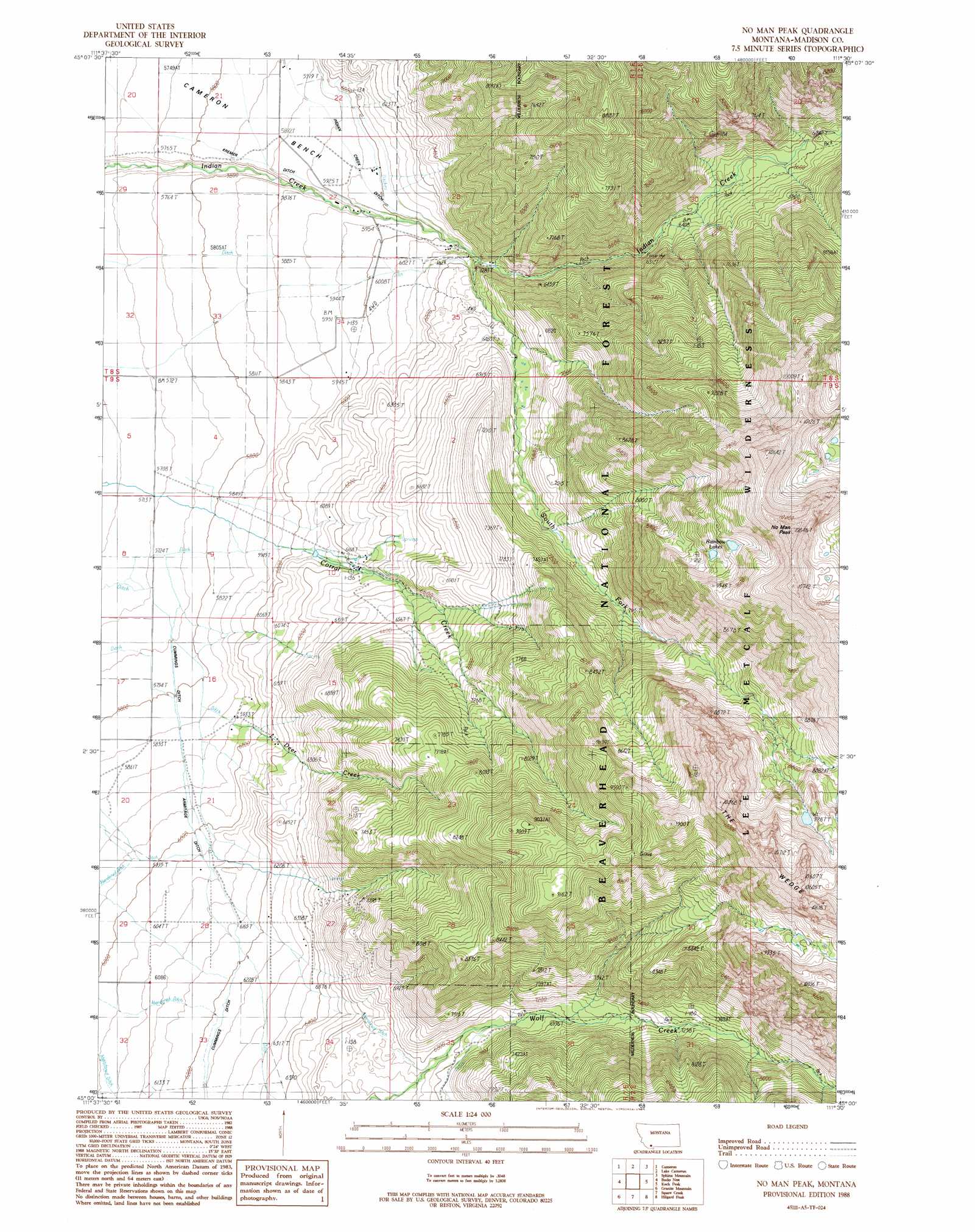
No Man Peak Topo Map Montana
To zoom in, hover over the map of No Man Peak
USGS Topo Quad 45111a5 - 1:24,000 scale
| Topo Map Name: | No Man Peak |
| USGS Topo Quad ID: | 45111a5 |
| Print Size: | ca. 21 1/4" wide x 27" high |
| Southeast Coordinates: | 45° N latitude / 111.5° W longitude |
| Map Center Coordinates: | 45.0625° N latitude / 111.5625° W longitude |
| U.S. State: | MT |
| Filename: | o45111a5.jpg |
| Download Map JPG Image: | No Man Peak topo map 1:24,000 scale |
| Map Type: | Topographic |
| Topo Series: | 7.5´ |
| Map Scale: | 1:24,000 |
| Source of Map Images: | United States Geological Survey (USGS) |
| Alternate Map Versions: |
No Man Peak MT 1988, updated 1989 Download PDF Buy paper map No Man Peak MT 1997, updated 2002 Download PDF Buy paper map No Man Peak MT 2011 Download PDF Buy paper map No Man Peak MT 2014 Download PDF Buy paper map |
| FStopo: | US Forest Service topo No Man Peak is available: Download FStopo PDF Download FStopo TIF |
1:24,000 Topo Quads surrounding No Man Peak
Eightmile Creek |
Ennis |
Fan Mountain |
Lone Mountain |
Gallatin Peak |
Varney |
Cameron |
Lake Cameron |
Sphinx Mountain |
Ousel Falls |
Broomtail Ridge |
Bucks Nest |
No Man Peak |
Koch Peak |
Lincoln Mountain |
Bighorn Mountain |
Granite Mountain |
Squaw Creek |
Hilgard Peak |
Pika Point |
Windy Hill |
Freezeout Mountain |
Cliff Lake |
Earthquake Lake |
Hebgen Dam |
> Back to 45111a1 at 1:100,000 scale
> Back to 45110a1 at 1:250,000 scale
> Back to U.S. Topo Maps home
No Man Peak topo map: Gazetteer
No Man Peak: Canals
Armitage Ditch elevation 1802m 5912′Cummings Ditch elevation 1896m 6220′
Wolf Creek Ditch elevation 2045m 6709′
No Man Peak: Lakes
Rainbow Lakes elevation 2849m 9347′No Man Peak: Ranges
The Wedge elevation 3215m 10547′No Man Peak: Streams
Deer Creek elevation 1759m 5770′South Fork Indian Creek elevation 1855m 6085′
No Man Peak: Summits
No Man Peak elevation 3285m 10777′No Man Peak: Wells
08S01E27DBAD01 Well elevation 1798m 5898′09S01E27CACD01 Well elevation 1927m 6322′
No Man Peak digital topo map on disk
Buy this No Man Peak topo map showing relief, roads, GPS coordinates and other geographical features, as a high-resolution digital map file on DVD: