Arbuckle Mountain Topo Map Oregon
To zoom in, hover over the map of Arbuckle Mountain
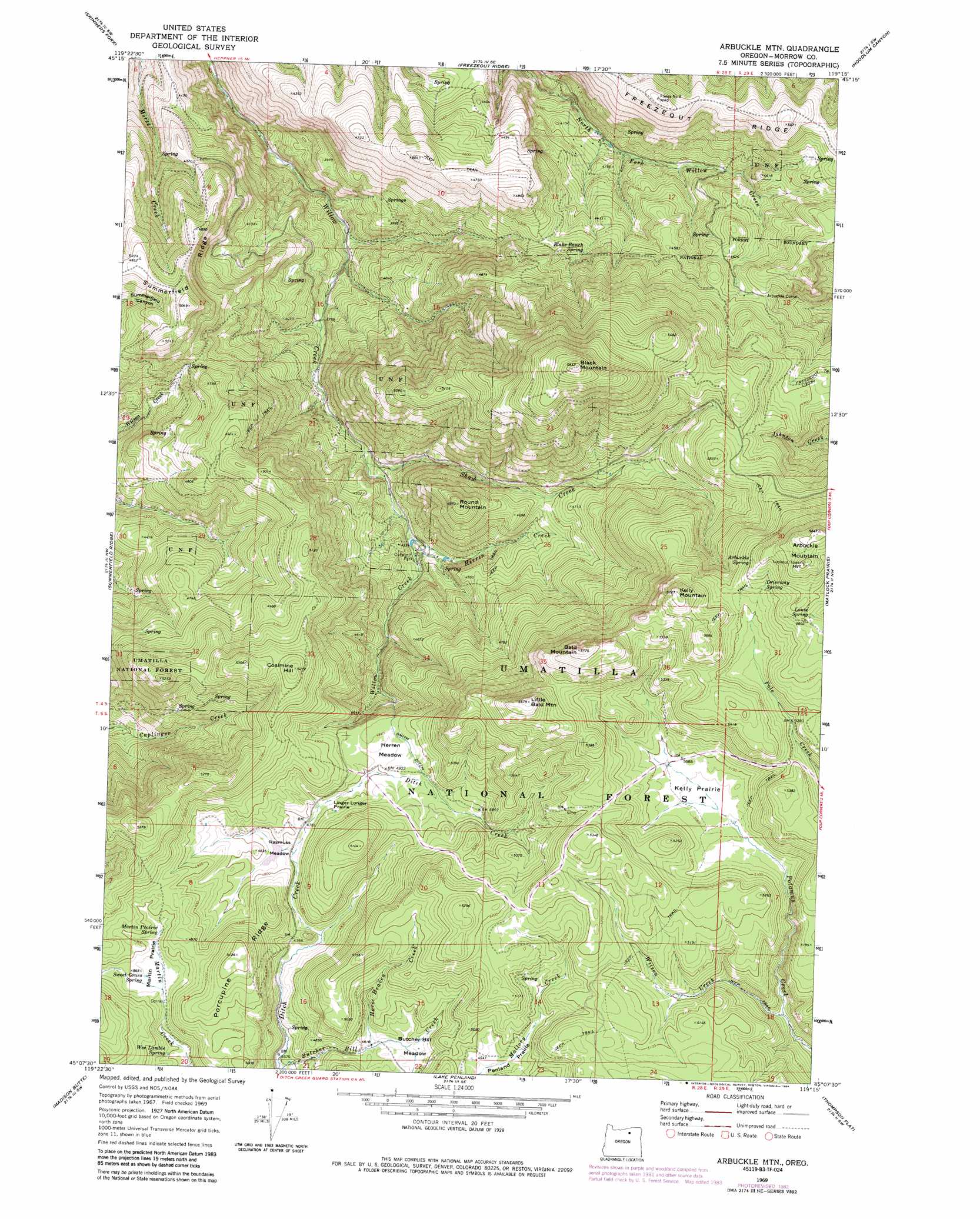
USGS Topo Quad 45119b3 - 1:24,000 scale
| Topo Map Name: | Arbuckle Mountain |
| USGS Topo Quad ID: | 45119b3 |
| Print Size: | ca. 21 1/4" wide x 27" high |
| Southeast Coordinates: | 45.125° N latitude / 119.25° W longitude |
| Map Center Coordinates: | 45.1875° N latitude / 119.3125° W longitude |
| U.S. State: | OR |
| Filename: | o45119b3.jpg |
| Download Map JPG Image: | Arbuckle Mountain topo map 1:24,000 scale |
| Map Type: | Topographic |
| Topo Series: | 7.5´ |
| Map Scale: | 1:24,000 |
| Source of Map Images: | United States Geological Survey (USGS) |
| Alternate Map Versions: |
Arbuckle Mtn OR 1969, updated 1973 Download PDF Buy paper map Arbuckle Mtn OR 1969, updated 1984 Download PDF Buy paper map Arbuckle Mountain OR 1995, updated 1998 Download PDF Buy paper map Arbuckle Mountain OR 2011 Download PDF Buy paper map Arbuckle Mountain OR 2014 Download PDF Buy paper map |
| FStopo: | US Forest Service topo Arbuckle Mountain is available: Download FStopo PDF Download FStopo TIF |
1:24,000 Topo Quads surrounding Arbuckle Mountain
Swaggart Buttes |
Gleason Butte |
Lena |
Franklin Hill |
Vinson |
Heppner |
Skinners Fork |
Freezeout Ridge |
Hoodlum Canyon |
Gurdane |
Balm Canyon |
Summerfield Ridge |
Arbuckle Mountain |
Matlock Prairie |
Sugarbowl Creek |
Big Rock Flat |
Madison Butte |
Lake Penland |
Thompson Flat |
Deerhorn Creek |
Turner Mountain |
Johnny Cake Mountain |
Slickear Mountain |
Ritter |
Meadow Brook Summit |
> Back to 45119a1 at 1:100,000 scale
> Back to 45118a1 at 1:250,000 scale
> Back to U.S. Topo Maps home
Arbuckle Mountain topo map: Gazetteer
Arbuckle Mountain: Canals
Smith Ditch elevation 1480m 4855′Arbuckle Mountain: Flats
Butcher Bill Meadow elevation 1477m 4845′Herren Meadow elevation 1469m 4819′
Kelly Prairie elevation 1542m 5059′
Linger Longer Prairie elevation 1459m 4786′
Martin Prairie elevation 1481m 4858′
Penland Prairie elevation 1511m 4957′
Rasmuss Meadow elevation 1451m 4760′
Arbuckle Mountain: Lakes
Blakes Pond elevation 1226m 4022′Cutsforth Pond elevation 1279m 4196′
Arbuckle Mountain: Parks
Cutsforth County Park elevation 1285m 4215′Arbuckle Mountain: Ridges
Freezeout Ridge elevation 1545m 5068′Porcupine Ridge elevation 1564m 5131′
Arbuckle Mountain: Springs
Arbuckle Spring elevation 1686m 5531′Blake Ranch Spring elevation 1380m 4527′
Driveway Spring elevation 1661m 5449′
Louse Spring elevation 1699m 5574′
Martin Prairie Spring elevation 1483m 4865′
Sweet Grass Spring elevation 1481m 4858′
Wee Lambie Spring elevation 1465m 4806′
Arbuckle Mountain: Streams
Herren Creek elevation 1275m 4183′Horse Heaven Creek elevation 1467m 4812′
Shaw Creek elevation 1234m 4048′
Wilson Creek elevation 1469m 4819′
Arbuckle Mountain: Summits
Arbuckle Mountain elevation 1780m 5839′Bald Mountain elevation 1757m 5764′
Black Mountain elevation 1799m 5902′
Coalmine Hill elevation 1605m 5265′
Kelly Mountain elevation 1746m 5728′
Little Bald Mountain elevation 1728m 5669′
Round Mountain elevation 1512m 4960′
Arbuckle Mountain digital topo map on disk
Buy this Arbuckle Mountain topo map showing relief, roads, GPS coordinates and other geographical features, as a high-resolution digital map file on DVD: