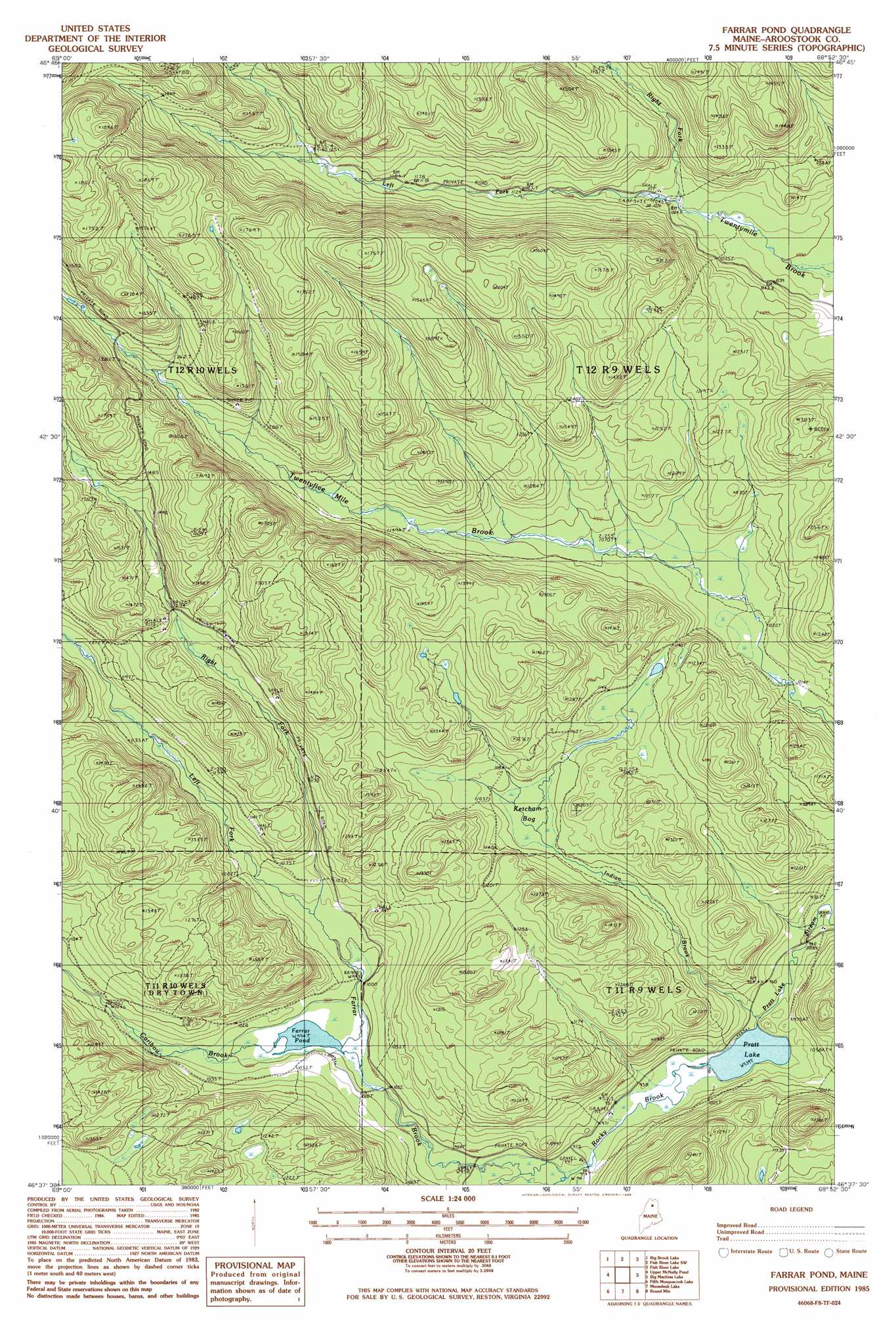
Farrar Pond Topo Map Maine
To zoom in, hover over the map of Farrar Pond
USGS Topo Quad 46068f8 - 1:24,000 scale
| Topo Map Name: | Farrar Pond |
| USGS Topo Quad ID: | 46068f8 |
| Print Size: | ca. 21 1/4" wide x 27" high |
| Southeast Coordinates: | 46.625° N latitude / 68.875° W longitude |
| Map Center Coordinates: | 46.6875° N latitude / 68.9375° W longitude |
| U.S. State: | ME |
| Filename: | o46068f8.jpg |
| Download Map JPG Image: | Farrar Pond topo map 1:24,000 scale |
| Map Type: | Topographic |
| Topo Series: | 7.5´ |
| Map Scale: | 1:24,000 |
| Source of Map Images: | United States Geological Survey (USGS) |
| Alternate Map Versions: |
Mooseleuk Lake NW ME 1975, updated 1981 Download PDF Buy paper map Farrar Pond ME 1985, updated 1986 Download PDF Buy paper map Farrar Pond ME 2011 Download PDF Buy paper map Farrar Pond ME 2014 Download PDF Buy paper map |
1:24,000 Topo Quads surrounding Farrar Pond
Allagash Falls |
Mckeen Lake |
Gardner Pond |
Deboullie Pond |
Island Pond |
Five Finger Brook |
Big Brook Lake |
Fish River Lake Sw |
Fish River Lake |
Carr Pond |
First Musquacook Lake |
Upper Mcnally Pond |
Farrar Pond |
Big Machias Lake |
Greenlaw Pond |
Third Musquacook Lake |
Fifth Musquacook Lake |
Mooseleuk Lake |
Round Mountain |
Jack Mountain |
Spider Lake |
Chase Lake |
Mooseleuk Mountain |
Middle Brook Mountain |
Chandler Mountain |
> Back to 46068e1 at 1:100,000 scale
> Back to 46068a1 at 1:250,000 scale
> Back to U.S. Topo Maps home
Farrar Pond topo map: Gazetteer
Farrar Pond: Dams
Upper McNally Pond Dam elevation 346m 1135′Farrar Pond: Lakes
Farrar Pond elevation 303m 994′Pratt Lake elevation 286m 938′
Farrar Pond: Reservoirs
Upper McNally Pond elevation 346m 1135′Farrar Pond: Streams
Caribou Brook elevation 303m 994′Indian Brook elevation 286m 938′
Left Fork Farrar Brook elevation 292m 958′
Left Fork Twentymile Brook elevation 317m 1040′
Right Fork Farrar Brook elevation 310m 1017′
Right Fork Twentymile Brook elevation 317m 1040′
Rocky Brook elevation 286m 938′
Farrar Pond: Swamps
Ketcham Bog elevation 332m 1089′Farrar Pond digital topo map on disk
Buy this Farrar Pond topo map showing relief, roads, GPS coordinates and other geographical features, as a high-resolution digital map file on DVD:
Maine, New Hampshire, Rhode Island & Eastern Massachusetts
Buy digital topo maps: Maine, New Hampshire, Rhode Island & Eastern Massachusetts