Clam Lake Topo Map Wisconsin
To zoom in, hover over the map of Clam Lake
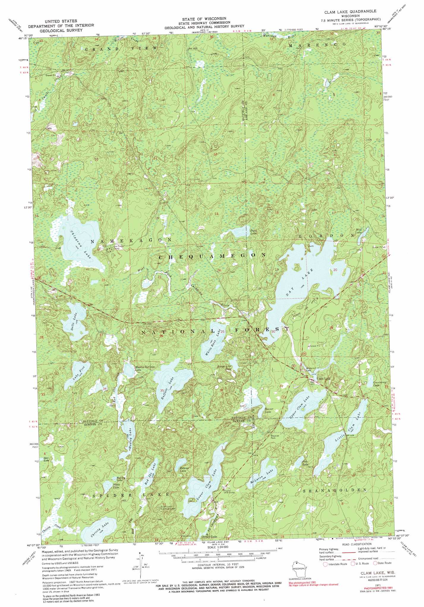
USGS Topo Quad 46090b8 - 1:24,000 scale
| Topo Map Name: | Clam Lake |
| USGS Topo Quad ID: | 46090b8 |
| Print Size: | ca. 21 1/4" wide x 27" high |
| Southeast Coordinates: | 46.125° N latitude / 90.875° W longitude |
| Map Center Coordinates: | 46.1875° N latitude / 90.9375° W longitude |
| U.S. State: | WI |
| Filename: | o46090b8.jpg |
| Download Map JPG Image: | Clam Lake topo map 1:24,000 scale |
| Map Type: | Topographic |
| Topo Series: | 7.5´ |
| Map Scale: | 1:24,000 |
| Source of Map Images: | United States Geological Survey (USGS) |
| Alternate Map Versions: |
Clam Lake WI 1971, updated 1990 Download PDF Buy paper map Clam Lake WI 2005, updated 2006 Download PDF Buy paper map Clam Lake WI 2011 Download PDF Buy paper map Clam Lake WI 2013 Download PDF Buy paper map Clam Lake WI 2015 Download PDF Buy paper map |
| FStopo: | US Forest Service topo Clam Lake is available: Download FStopo PDF Download FStopo TIF |
1:24,000 Topo Quads surrounding Clam Lake
Grandview Nw |
Mason |
Sanborn |
Marengo |
High Bridge |
Diamond Lake |
Grand View |
Marengo Lake |
Mineral Lake |
Mellen |
Lake Tahkodah |
Namekagon Lake |
Clam Lake |
Clam Lake Ne |
Morse |
Spider Lake |
Moose Lake |
Clam Lake Sw |
Clam Lake Se |
Shanagolden |
New Post |
Barker Lake |
Blaisdell Lake |
Loretta |
Kennedy |
> Back to 46090a1 at 1:100,000 scale
> Back to 46090a1 at 1:250,000 scale
> Back to U.S. Topo Maps home
Clam Lake topo map: Gazetteer
Clam Lake: Airports
Little Clam Lake Seaplane Base elevation 439m 1440′Clam Lake: Dams
Day Dam elevation 436m 1430′Lower Clam Lake Dam elevation 427m 1400′
Turtle Lake 2WP845 Dam elevation 443m 1453′
Clam Lake: Lakes
Beaver Lake elevation 433m 1420′Bentley Lake elevation 439m 1440′
Buffalo Lake elevation 443m 1453′
Chippewa Lake elevation 447m 1466′
Christy Lake elevation 436m 1430′
Cranberry Lake elevation 434m 1423′
Day Lake elevation 436m 1430′
Delano Lake elevation 430m 1410′
Dells Lake elevation 447m 1466′
Duck Lake elevation 442m 1450′
Hadley Lake elevation 440m 1443′
Lake Five elevation 447m 1466′
Little Clam Lake elevation 439m 1440′
Lower Clam Lake elevation 427m 1400′
McLaren Lake elevation 436m 1430′
Mud Lake elevation 435m 1427′
Muskie Springs Lake elevation 440m 1443′
Noble Lake elevation 436m 1430′
Pole Lake elevation 428m 1404′
Range Line Lake elevation 440m 1443′
Red Ike Lake elevation 433m 1420′
Spot Lake elevation 435m 1427′
Upper Clam Lake elevation 430m 1410′
White Bass Lake elevation 440m 1443′
Clam Lake: Parks
Spider Lake State Natural Area elevation 447m 1466′Clam Lake: Populated Places
Clam Lake elevation 437m 1433′Clam Lake: Reservoirs
Day Lake elevation 436m 1430′Lower Clam Lake 16 elevation 427m 1400′
North and South Turtle Lakes 25 elevation 443m 1453′
Clam Lake digital topo map on disk
Buy this Clam Lake topo map showing relief, roads, GPS coordinates and other geographical features, as a high-resolution digital map file on DVD: