Grandview Nw Topo Map Wisconsin
To zoom in, hover over the map of Grandview Nw
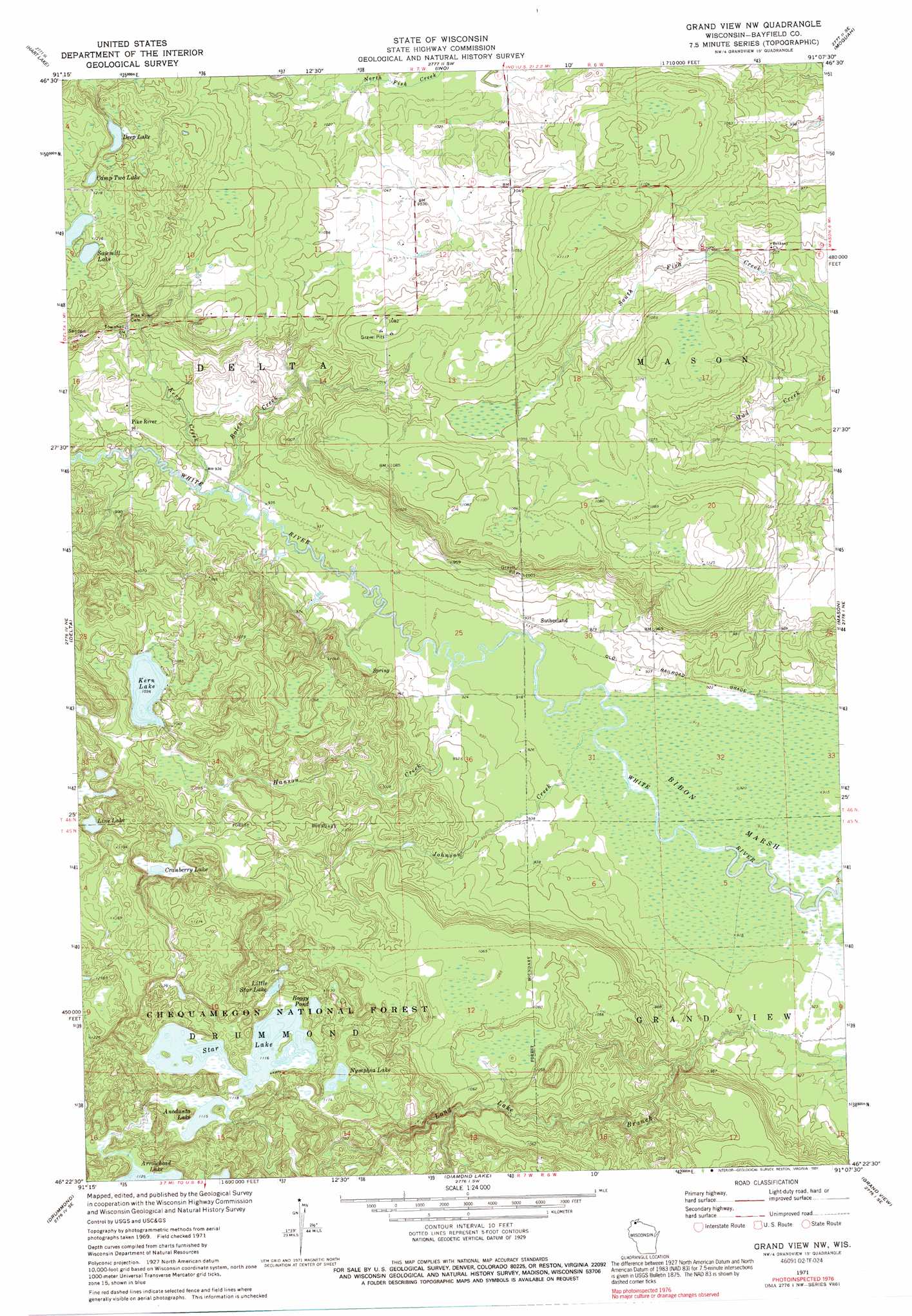
USGS Topo Quad 46091d2 - 1:24,000 scale
| Topo Map Name: | Grandview Nw |
| USGS Topo Quad ID: | 46091d2 |
| Print Size: | ca. 21 1/4" wide x 27" high |
| Southeast Coordinates: | 46.375° N latitude / 91.125° W longitude |
| Map Center Coordinates: | 46.4375° N latitude / 91.1875° W longitude |
| U.S. State: | WI |
| Filename: | o46091d2.jpg |
| Download Map JPG Image: | Grandview Nw topo map 1:24,000 scale |
| Map Type: | Topographic |
| Topo Series: | 7.5´ |
| Map Scale: | 1:24,000 |
| Source of Map Images: | United States Geological Survey (USGS) |
| Alternate Map Versions: |
Grand View NW WI 1971, updated 1973 Download PDF Buy paper map Grand View NW WI 1971, updated 1985 Download PDF Buy paper map Grand View NW WI 1971, updated 1991 Download PDF Buy paper map Grand View NW WI 2005, updated 2006 Download PDF Buy paper map Grandview NW WI 2011 Download PDF Buy paper map Grandview NW WI 2013 Download PDF Buy paper map Grandview NW WI 2015 Download PDF Buy paper map |
| FStopo: | US Forest Service topo Grand View NW is available: Download FStopo PDF Download FStopo TIF |
1:24,000 Topo Quads surrounding Grandview Nw
Blaine Creek |
Iron Lake Ne |
Moquah Nw |
Mount Valhalla |
Washburn |
Iron Lake |
Hart Lake |
Ino |
Moquah |
Ashland West |
Drummond Nw |
Delta |
Grandview Nw |
Mason |
Sanborn |
Upper Eau Claire Lake |
Drummond |
Diamond Lake |
Grand View |
Marengo Lake |
Totagatic Lake |
Cable |
Lake Tahkodah |
Namekagon Lake |
Clam Lake |
> Back to 46091a1 at 1:100,000 scale
> Back to 46090a1 at 1:250,000 scale
> Back to U.S. Topo Maps home
Grandview Nw topo map: Gazetteer
Grandview Nw: Lakes
Anodanta Lake elevation 340m 1115′Boggy Pond elevation 343m 1125′
Camp Two Lake elevation 361m 1184′
Cranberry Lake elevation 315m 1033′
Deep Lake elevation 362m 1187′
Kern Lake elevation 316m 1036′
Line Lake elevation 337m 1105′
Little Star Lake elevation 342m 1122′
Nymphia Lake elevation 340m 1115′
Sawmill Lake elevation 364m 1194′
Star Lake elevation 340m 1115′
Grandview Nw: Parks
Sajdak Springs State Natural Area elevation 283m 928′Grandview Nw: Populated Places
Pike River elevation 293m 961′Sutherland elevation 284m 931′
Grandview Nw: Streams
Bolen Creek elevation 283m 928′Hanson Creek elevation 279m 915′
Jader Creek elevation 311m 1020′
Johnson Creek elevation 278m 912′
Kern Creek elevation 282m 925′
Grandview Nw digital topo map on disk
Buy this Grandview Nw topo map showing relief, roads, GPS coordinates and other geographical features, as a high-resolution digital map file on DVD: