White Sulphur Springs Topo Map Montana
To zoom in, hover over the map of White Sulphur Springs
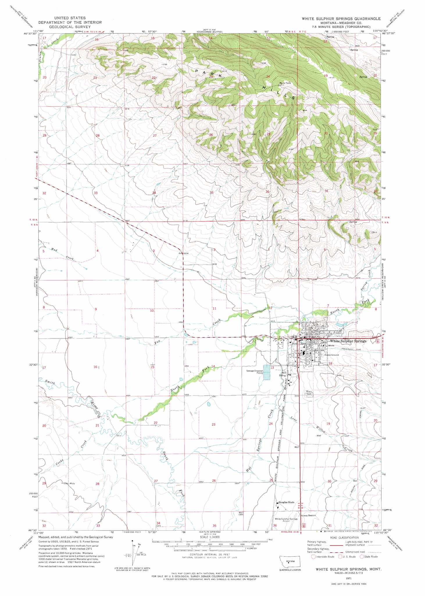
USGS Topo Quad 46110e8 - 1:24,000 scale
| Topo Map Name: | White Sulphur Springs |
| USGS Topo Quad ID: | 46110e8 |
| Print Size: | ca. 21 1/4" wide x 27" high |
| Southeast Coordinates: | 46.5° N latitude / 110.875° W longitude |
| Map Center Coordinates: | 46.5625° N latitude / 110.9375° W longitude |
| U.S. State: | MT |
| Filename: | o46110e8.jpg |
| Download Map JPG Image: | White Sulphur Springs topo map 1:24,000 scale |
| Map Type: | Topographic |
| Topo Series: | 7.5´ |
| Map Scale: | 1:24,000 |
| Source of Map Images: | United States Geological Survey (USGS) |
| Alternate Map Versions: |
White Sulphur Springs MT 1971, updated 1974 Download PDF Buy paper map White Sulphur Springs MT 1995, updated 1997 Download PDF Buy paper map White Sulphur Springs MT 2011 Download PDF Buy paper map White Sulphur Springs MT 2014 Download PDF Buy paper map |
| FStopo: | US Forest Service topo White Sulphur Springs is available: Download FStopo PDF Download FStopo TIF |
1:24,000 Topo Quads surrounding White Sulphur Springs
Devils Footstool |
Sheep Mountain |
Strawberry Butte |
Moose Mountain |
Kings Hill |
Fort Logan |
Whitetail Reservoir |
Coxcombe Butte |
Charcoal Gulch |
Volcano Butte |
Gipsy Lake |
Hanson Reservoir |
White Sulphur Springs |
Pinchout Creek |
Fourmile Spring |
Mount Edith |
Alkali Lake |
Catlin Spring |
Manger Park |
Castle Town |
Sulphur Bar Creek |
Battle Mountain |
Black Butte Mountain |
Ringling |
Hamen |
> Back to 46110e1 at 1:100,000 scale
> Back to 46110a1 at 1:250,000 scale
> Back to U.S. Topo Maps home
White Sulphur Springs topo map: Gazetteer
White Sulphur Springs: Airports
White Sulphur Springs Airport elevation 1532m 5026′White Sulphur Springs Ranger Station Heliport elevation 1530m 5019′
White Sulphur Springs: Parks
Kaldor Park elevation 1535m 5036′Rader Park elevation 1537m 5042′
White Sulphur Springs City Park elevation 1536m 5039′
White Sulphur Springs: Pillars
The Castle elevation 1555m 5101′White Sulphur Springs: Populated Places
Doak Trailer Court elevation 1565m 5134′Jerry Mallo Trailer Court elevation 1531m 5022′
Mikesell Trailer Court elevation 1530m 5019′
Richards Trailer Court elevation 1526m 5006′
White Sulphur Springs elevation 1537m 5042′
White Sulphur Springs: Post Offices
White Sulphur Springs Post Office elevation 1534m 5032′White Sulphur Springs: Ranges
Park Hills elevation 1908m 6259′White Sulphur Springs: Springs
09N07E18BBB_01 Spring elevation 1532m 5026′09N07E18BBBD01 Spring elevation 1536m 5039′
White Sulphur Springs: Streams
Cooks Creek elevation 1498m 4914′Hot Springs Creek elevation 1503m 4931′
Lone Willow Creek elevation 1522m 4993′
North Fork Smith River elevation 1495m 4904′
South Fork Smith River elevation 1495m 4904′
Spring Creek elevation 1543m 5062′
White Sulphur Springs: Wells
09N06E02AC__01 Well elevation 1555m 5101′09N06E02D___01 Well elevation 1538m 5045′
09N06E05AC__01 Well elevation 1496m 4908′
09N06E09CD__01 Well elevation 1498m 4914′
09N06E09D___01 Well elevation 1501m 4924′
09N06E10A___01 Well elevation 1514m 4967′
09N06E10D___01 Well elevation 1511m 4957′
09N06E12ACC_01 Well elevation 1531m 5022′
09N06E12CA__01 Well elevation 1527m 5009′
09N06E13AAA_01 Well elevation 1533m 5029′
09N06E13D___01 Well elevation 1528m 5013′
09N06E14B___01 Well elevation 1514m 4967′
09N06E14BB__01 Well elevation 1514m 4967′
09N06E14DA__01 Well elevation 1519m 4983′
09N06E17A___01 Well elevation 1492m 4895′
09N06E21C___01 Well elevation 1504m 4934′
09N06E22BD__01 Well elevation 1501m 4924′
09N06E22CB__01 Well elevation 1500m 4921′
09N06E24B___01 Well elevation 1519m 4983′
09N06E24BB__01 Well elevation 1515m 4970′
09N06E24BB__02 Well elevation 1515m 4970′
09N06E24DA__01 Well elevation 1533m 5029′
09N06E25BA__01 Well elevation 1523m 4996′
09N06E25DA__01 Well elevation 1536m 5039′
09N06E25DC__01 Well elevation 1533m 5029′
09N06E26DC__01 Well elevation 1517m 4977′
09N06E28AA__01 Well elevation 1509m 4950′
09N06E28CA__01 Well elevation 1521m 4990′
09N07E07CA__01 Well elevation 1551m 5088′
09N07E07CD__01 Well elevation 1545m 5068′
09N07E08C___01 Well elevation 1549m 5082′
09N07E19C___01 Well elevation 1540m 5052′
09N07E19C___02 Well elevation 1540m 5052′
10N06E17DC__01 Well elevation 1514m 4967′
10N06E22C___01 Well elevation 1619m 5311′
10N06E28C___01 Well elevation 1530m 5019′
White Sulphur Springs digital topo map on disk
Buy this White Sulphur Springs topo map showing relief, roads, GPS coordinates and other geographical features, as a high-resolution digital map file on DVD: