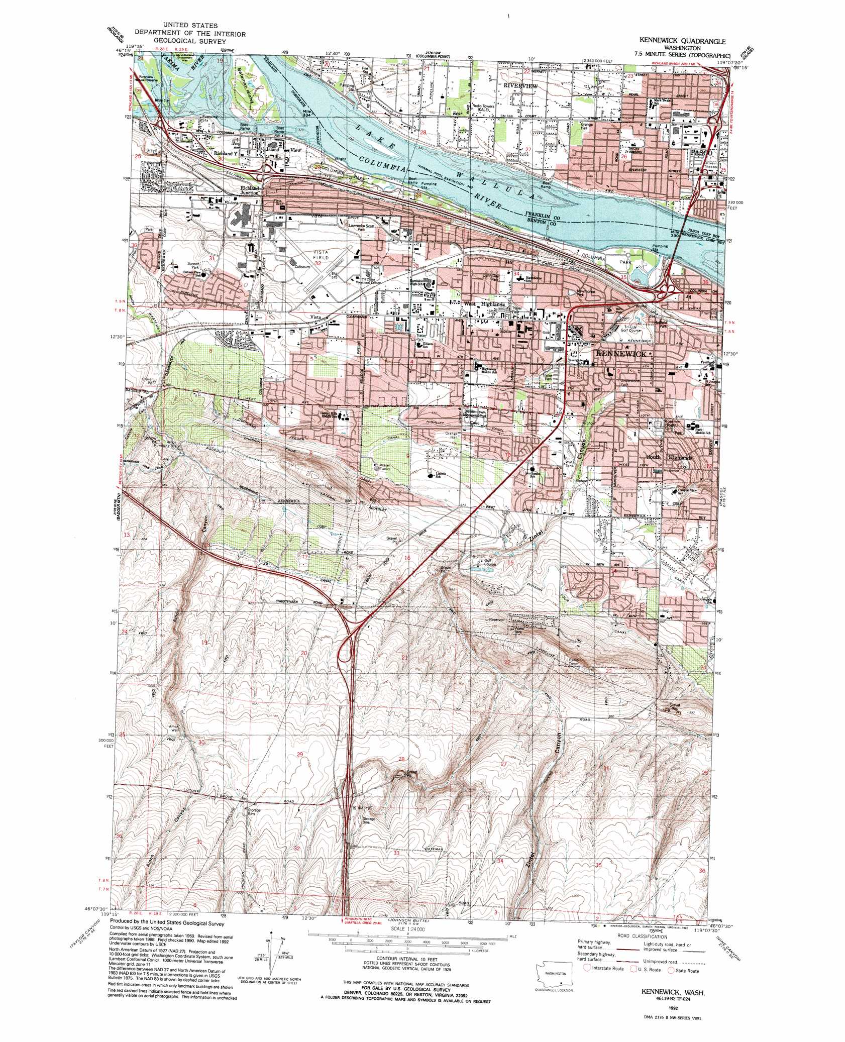
Kennewick Topo Map Washington
To zoom in, hover over the map of Kennewick
USGS Topo Quad 46119b2 - 1:24,000 scale
| Topo Map Name: | Kennewick |
| USGS Topo Quad ID: | 46119b2 |
| Print Size: | ca. 21 1/4" wide x 27" high |
| Southeast Coordinates: | 46.125° N latitude / 119.125° W longitude |
| Map Center Coordinates: | 46.1875° N latitude / 119.1875° W longitude |
| U.S. State: | WA |
| Filename: | o46119b2.jpg |
| Download Map JPG Image: | Kennewick topo map 1:24,000 scale |
| Map Type: | Topographic |
| Topo Series: | 7.5´ |
| Map Scale: | 1:24,000 |
| Source of Map Images: | United States Geological Survey (USGS) |
| Alternate Map Versions: |
Kennewick WA 1964, updated 1966 Download PDF Buy paper map Kennewick WA 1964, updated 1974 Download PDF Buy paper map Kennewick WA 1992, updated 1992 Download PDF Buy paper map Kennewick WA 2011 Download PDF Buy paper map Kennewick WA 2013 Download PDF Buy paper map |
1:24,000 Topo Quads surrounding Kennewick
Horn Rapids Dam |
Wooded Island |
Mathews Corner |
Eltopia |
Rye Grass Coulee |
Benton City |
Richland |
Columbia Point |
Glade |
Levey Sw |
Webber Canyon |
Badger Mountain |
Kennewick |
Pasco |
Humorist |
Prior Ranch |
Taylor Canyon |
Johnson Butte |
Nine Canyon |
Wallula |
Irrigon |
Umatilla |
Hat Rock |
Juniper |
Juniper Canyon |
> Back to 46119a1 at 1:100,000 scale
> Back to 46118a1 at 1:250,000 scale
> Back to U.S. Topo Maps home
Kennewick topo map: Gazetteer
Kennewick: Airports
Vista Field elevation 155m 508′Kennewick: Canals
A P Canal elevation 261m 856′A P Lateral elevation 274m 898′
Amon Wasteway elevation 152m 498′
Highland Feeder Canal elevation 186m 610′
Highlift Canal elevation 170m 557′
Lateral Number 1.8 (historical) elevation 187m 613′
Kennewick: Dams
Columbia Park Dam elevation 108m 354′Kennewick: Islands
Wade Island elevation 104m 341′Kennewick: Parks
Chiawana Park elevation 110m 360′Columbia Park (historical) elevation 104m 341′
Fruitland Park elevation 111m 364′
Hatfield Park elevation 124m 406′
John Day Park elevation 150m 492′
Lawrence Scott Park elevation 142m 465′
Sanders Field elevation 150m 492′
Underwood Park elevation 132m 433′
Kennewick: Populated Places
Island View elevation 104m 341′Kennewick elevation 124m 406′
Pasco West elevation 109m 357′
Richland Junction elevation 120m 393′
Richland Y elevation 115m 377′
Riverview elevation 109m 357′
Riverview elevation 113m 370′
South Highlands elevation 154m 505′
Vista elevation 165m 541′
West Highlands elevation 156m 511′
West Pasco elevation 110m 360′
Kennewick: Valleys
Amon Canyon elevation 166m 544′Coyote Canyon elevation 169m 554′
Zintel Canyon elevation 136m 446′
Kennewick: Wells
Amon Well elevation 325m 1066′Kennewick digital topo map on disk
Buy this Kennewick topo map showing relief, roads, GPS coordinates and other geographical features, as a high-resolution digital map file on DVD: