Sioux Pine Island Topo Map Minnesota
To zoom in, hover over the map of Sioux Pine Island
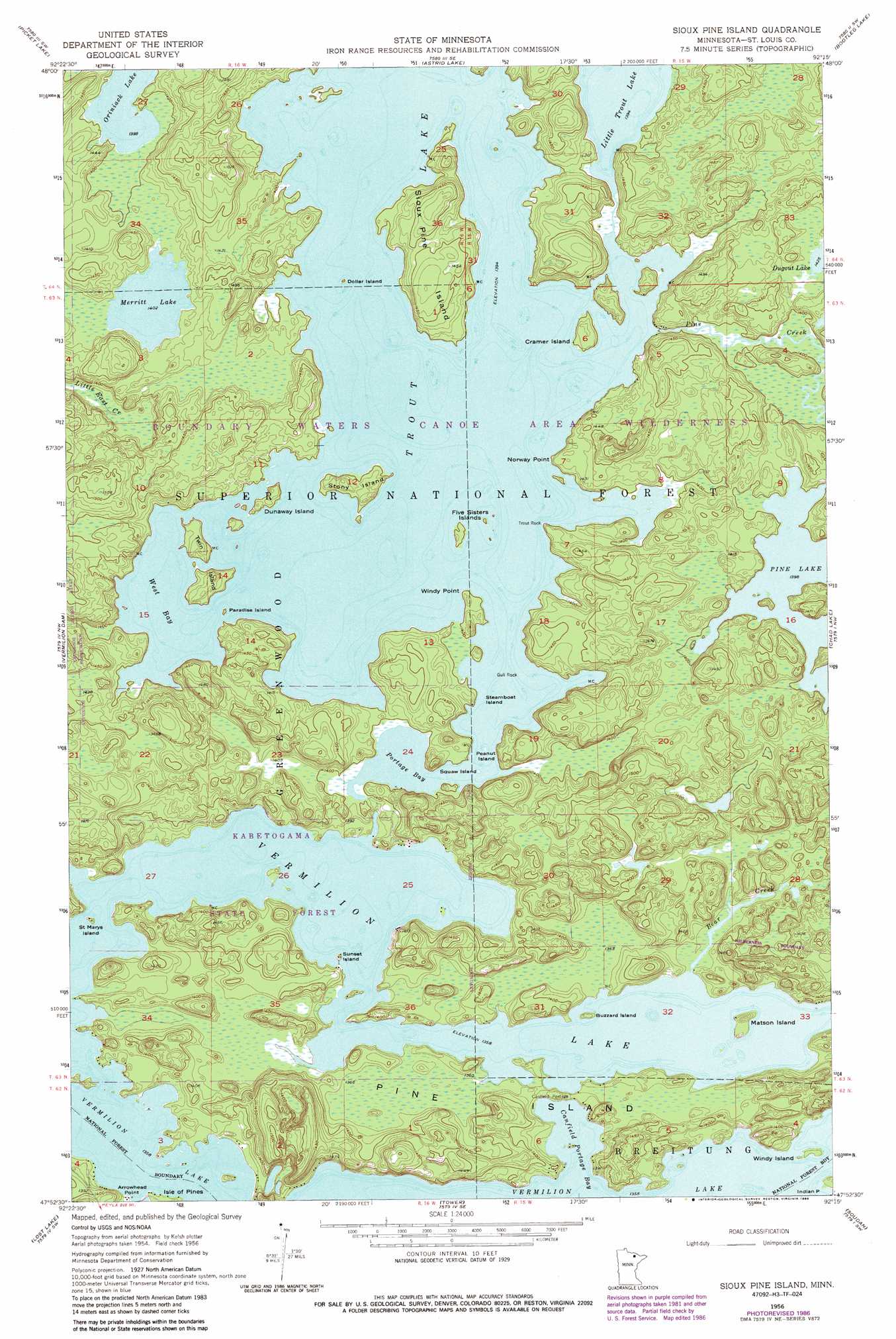
USGS Topo Quad 47092h3 - 1:24,000 scale
| Topo Map Name: | Sioux Pine Island |
| USGS Topo Quad ID: | 47092h3 |
| Print Size: | ca. 21 1/4" wide x 27" high |
| Southeast Coordinates: | 47.875° N latitude / 92.25° W longitude |
| Map Center Coordinates: | 47.9375° N latitude / 92.3125° W longitude |
| U.S. State: | MN |
| Filename: | o47092h3.jpg |
| Download Map JPG Image: | Sioux Pine Island topo map 1:24,000 scale |
| Map Type: | Topographic |
| Topo Series: | 7.5´ |
| Map Scale: | 1:24,000 |
| Source of Map Images: | United States Geological Survey (USGS) |
| Alternate Map Versions: |
Sioux Pine Island MN 1956, updated 1958 Download PDF Buy paper map Sioux Pine Island MN 1956, updated 1963 Download PDF Buy paper map Sioux Pine Island MN 1956, updated 1974 Download PDF Buy paper map Sioux Pine Island MN 1956, updated 1982 Download PDF Buy paper map Sioux Pine Island MN 1956, updated 1986 Download PDF Buy paper map Sioux Pine Island MN 2011 Download PDF Buy paper map Sioux Pine Island MN 2013 Download PDF Buy paper map Sioux Pine Island MN 2016 Download PDF Buy paper map |
| FStopo: | US Forest Service topo Sioux Pine Island is available: Download FStopo PDF Download FStopo TIF |
1:24,000 Topo Quads surrounding Sioux Pine Island
Kabustasa Lake |
Echo Lake |
Lake Jeanette |
Shell Lake |
Lake Agnes |
Buyck |
Picket Lake |
Astrid Lake |
Bootleg Lake |
Lapond Lake |
Norwegian Bay |
Vermilion Dam |
Sioux Pine Island |
Chad Lake |
Crab Lake |
Sassas Creek |
Lost Lake |
Tower |
Soudan |
Eagles Nest |
Britt |
Biwabik Nw |
Biwabik Ne |
Embarrass |
Isaac Lake |
> Back to 47092e1 at 1:100,000 scale
> Back to 47092a1 at 1:250,000 scale
> Back to U.S. Topo Maps home
Sioux Pine Island topo map: Gazetteer
Sioux Pine Island: Bays
Canfield Portage Bay elevation 414m 1358′Portage Bay elevation 425m 1394′
West Bay elevation 425m 1394′
Sioux Pine Island: Capes
Arrowhead Point elevation 415m 1361′Norway Point elevation 434m 1423′
Trout Rock elevation 431m 1414′
Windy Point elevation 432m 1417′
Sioux Pine Island: Islands
Buzzard Island elevation 415m 1361′Cramer Island elevation 433m 1420′
Dollar Island elevation 425m 1394′
Dunaway Island elevation 433m 1420′
Equay Island elevation 425m 1394′
Five Sisters Islands elevation 429m 1407′
Gull Rock elevation 425m 1394′
Matson Island elevation 418m 1371′
Paradise Island elevation 427m 1400′
Peanut Island elevation 425m 1394′
Pine Island elevation 429m 1407′
Saint Marys Island elevation 414m 1358′
Sioux Pine Island elevation 444m 1456′
Steamboat Island elevation 425m 1394′
Stony Island elevation 430m 1410′
Sunset Island elevation 416m 1364′
Twin Island elevation 431m 1414′
Windy Island elevation 414m 1358′
Sioux Pine Island: Lakes
Little Trout Lake elevation 425m 1394′Merritt Lake elevation 428m 1404′
Trout Lake elevation 425m 1394′
Vermilion Lake elevation 420m 1377′
Sioux Pine Island: Streams
Bear Creek elevation 414m 1358′Pine Creek elevation 425m 1394′
Sioux Pine Island: Trails
Canfield Portage elevation 420m 1377′Sioux Pine Island digital topo map on disk
Buy this Sioux Pine Island topo map showing relief, roads, GPS coordinates and other geographical features, as a high-resolution digital map file on DVD: