Seventytwo Hills Topo Map Montana
To zoom in, hover over the map of Seventytwo Hills
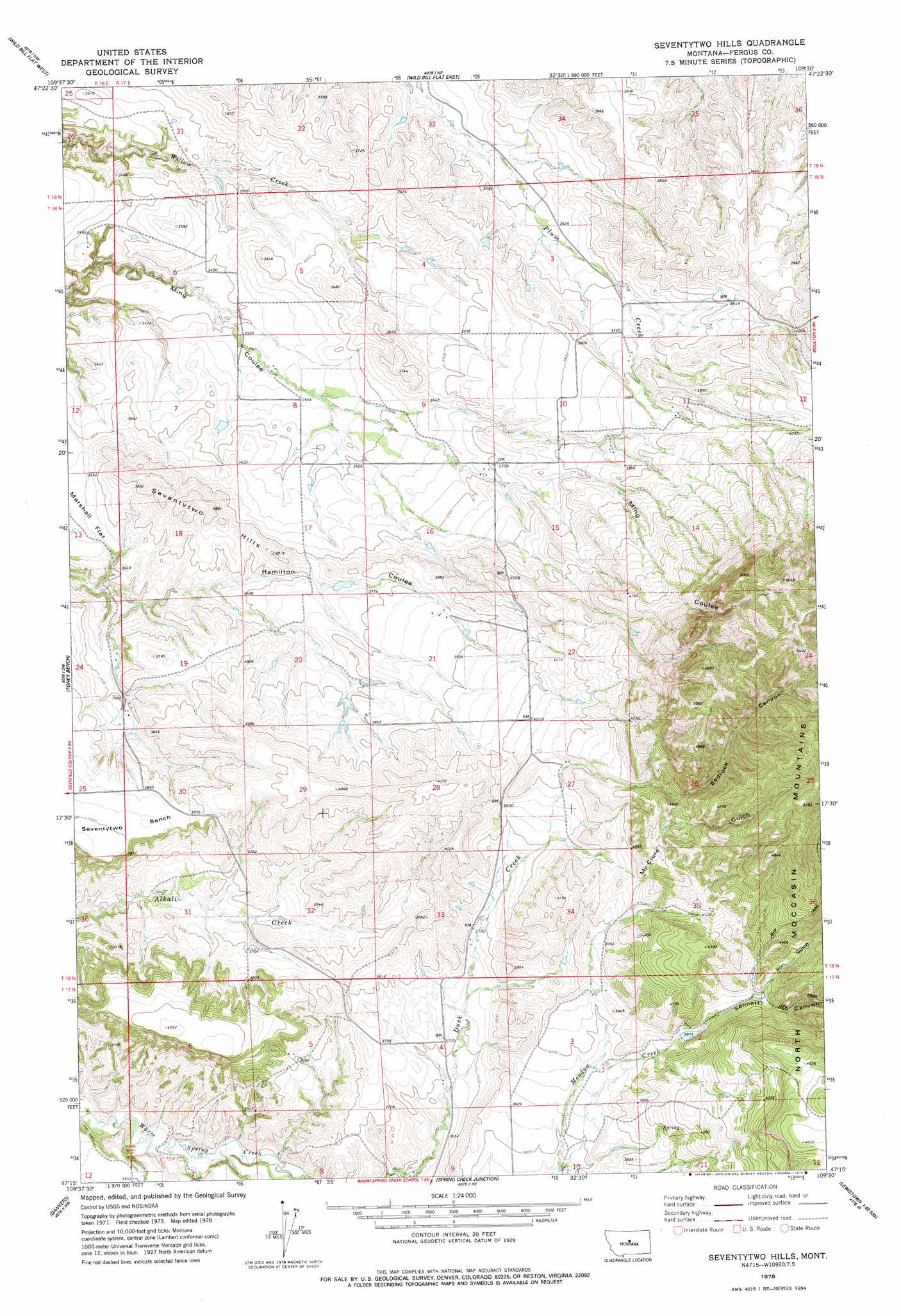
USGS Topo Quad 47109c5 - 1:24,000 scale
| Topo Map Name: | Seventytwo Hills |
| USGS Topo Quad ID: | 47109c5 |
| Print Size: | ca. 21 1/4" wide x 27" high |
| Southeast Coordinates: | 47.25° N latitude / 109.5° W longitude |
| Map Center Coordinates: | 47.3125° N latitude / 109.5625° W longitude |
| U.S. State: | MT |
| Filename: | o47109c5.jpg |
| Download Map JPG Image: | Seventytwo Hills topo map 1:24,000 scale |
| Map Type: | Topographic |
| Topo Series: | 7.5´ |
| Map Scale: | 1:24,000 |
| Source of Map Images: | United States Geological Survey (USGS) |
| Alternate Map Versions: |
Seventytwo Hills MT 1978, updated 1979 Download PDF Buy paper map Seventytwo Hills MT 2011 Download PDF Buy paper map Seventytwo Hills MT 2014 Download PDF Buy paper map |
1:24,000 Topo Quads surrounding Seventytwo Hills
Spring Coulee |
Wolf Creek Falls |
Anderson Bridge |
Winifred West |
Winifred East |
Soda Spring Coulee |
Wild Bill Flat West |
Wild Bill Flat East |
Hilger Nw |
Christina |
Hoosac |
Toney Bench |
Seventytwo Hills |
Kendall |
Hilger |
Harwood Bench |
Danvers |
Spring Creek Junction |
Brooks |
New Year |
Kolin |
Ross Fork |
Glengarry |
Lewistown |
Pike Creek |
> Back to 47109a1 at 1:100,000 scale
> Back to 47108a1 at 1:250,000 scale
> Back to U.S. Topo Maps home
Seventytwo Hills topo map: Gazetteer
Seventytwo Hills: Dams
Norman Dam elevation 1091m 3579′Seventytwo Hills: Mines
Iron Gulch Number 2 Mine elevation 1423m 4668′Seventytwo Hills: Post Offices
Moccasin Post Office (historical) elevation 1450m 4757′Plum Creek Post Office (historical) elevation 1133m 3717′
Senate Post Office (historical) elevation 1144m 3753′
Seventytwo Hills: Summits
Seventytwo Hills elevation 1169m 3835′Seventytwo Hills: Valleys
Bedrock Canyon elevation 1226m 4022′Iron Gulch elevation 1241m 4071′
McClure Gulch elevation 1200m 3937′
Sennett Canyon elevation 1176m 3858′
Seventytwo Hills: Wells
17N17E05CAB_01 Well elevation 1134m 3720′18N16E01ADB_01 Well elevation 1060m 3477′
18N17E02CBC_01 Well elevation 1133m 3717′
18N17E19CCC_01 Well elevation 1134m 3720′
18N17E20DDD_01 Well elevation 1168m 3832′
18N17E21ABC_01 Well elevation 1178m 3864′
Seventytwo Hills digital topo map on disk
Buy this Seventytwo Hills topo map showing relief, roads, GPS coordinates and other geographical features, as a high-resolution digital map file on DVD: