Johnson Mountain Topo Map Montana
To zoom in, hover over the map of Johnson Mountain
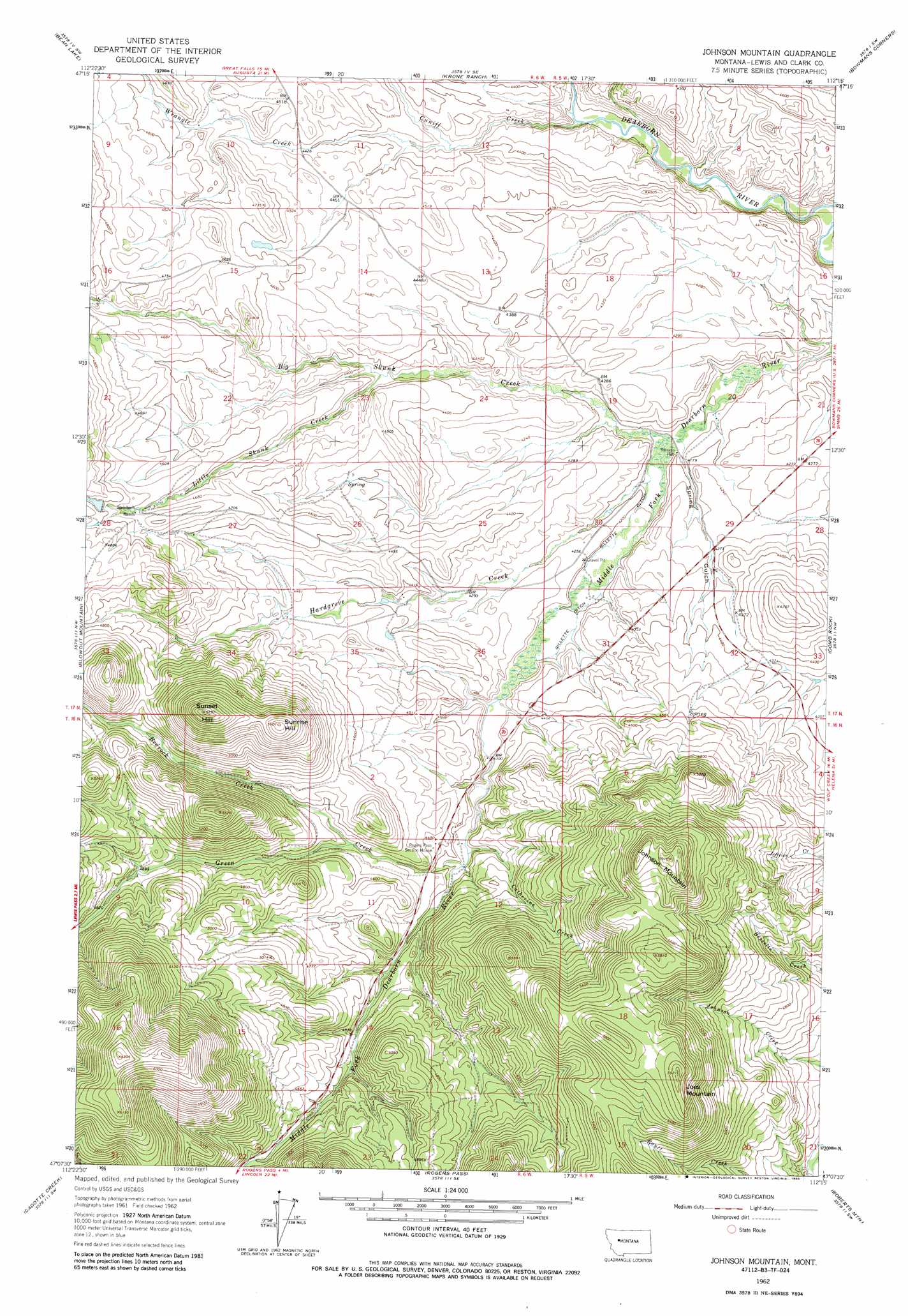
USGS Topo Quad 47112b3 - 1:24,000 scale
| Topo Map Name: | Johnson Mountain |
| USGS Topo Quad ID: | 47112b3 |
| Print Size: | ca. 21 1/4" wide x 27" high |
| Southeast Coordinates: | 47.125° N latitude / 112.25° W longitude |
| Map Center Coordinates: | 47.1875° N latitude / 112.3125° W longitude |
| U.S. State: | MT |
| Filename: | o47112b3.jpg |
| Download Map JPG Image: | Johnson Mountain topo map 1:24,000 scale |
| Map Type: | Topographic |
| Topo Series: | 7.5´ |
| Map Scale: | 1:24,000 |
| Source of Map Images: | United States Geological Survey (USGS) |
| Alternate Map Versions: |
Johnson Mountain MT 1962, updated 1965 Download PDF Buy paper map Johnson Mountain MT 1962, updated 1979 Download PDF Buy paper map Johnson Mountain MT 1962, updated 1985 Download PDF Buy paper map Johnson Mountain MT 2011 Download PDF Buy paper map Johnson Mountain MT 2014 Download PDF Buy paper map |
1:24,000 Topo Quads surrounding Johnson Mountain
Nilan Reservoir |
Augusta |
Gouchnour Ranch |
Bowmans Corners Nw |
Bowmans Corners Ne |
Steamboat Mountain |
Bean Lake |
Krone Ranch |
Bowmans Corners |
Henry Creek |
Caribou Peak |
Blowout Mountain |
Johnson Mountain |
Comb Rock |
Coburn Mountain |
Silver King Mountain |
Cadotte Creek |
Rogers Pass |
Roberts Mountain |
Wolf Creek |
Swede Gulch |
Stemple Pass |
Wilborn |
Mitchell Mountain |
Sheep Creek |
> Back to 47112a1 at 1:100,000 scale
> Back to 47112a1 at 1:250,000 scale
> Back to U.S. Topo Maps home
Johnson Mountain topo map: Gazetteer
Johnson Mountain: Canals
Gillette Ditch elevation 1276m 4186′Johnson Mountain: Post Offices
Stearns Post Office (historical) elevation 1269m 4163′Johnson Mountain: Streams
Bedrock Creek elevation 1367m 4484′Big Skunk Creek elevation 1264m 4146′
Catherine Creek elevation 1324m 4343′
Cuniff Creek elevation 1275m 4183′
Green Creek elevation 1328m 4356′
Hardgrove Creek elevation 1264m 4146′
Little Skunk Creek elevation 1321m 4333′
Roberts Creek elevation 1312m 4304′
Wrangle Creek elevation 1316m 4317′
Johnson Mountain: Summits
Joes Mountain elevation 1796m 5892′Johnson Mountain elevation 1804m 5918′
Sunrise Hill elevation 1707m 5600′
Sunset Hill elevation 1765m 5790′
Johnson Mountain: Valleys
Spring Gulch elevation 1269m 4163′Johnson Mountain digital topo map on disk
Buy this Johnson Mountain topo map showing relief, roads, GPS coordinates and other geographical features, as a high-resolution digital map file on DVD: