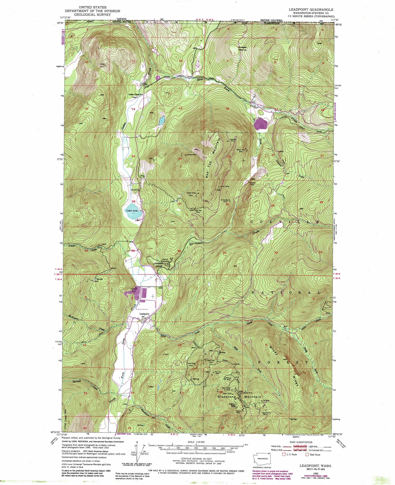
Leadpoint Topo Map Washington
To zoom in, hover over the map of Leadpoint
USGS Topo Quad 48117h5 - 1:24,000 scale
| Topo Map Name: | Leadpoint |
| USGS Topo Quad ID: | 48117h5 |
| Print Size: | ca. 21 1/4" wide x 27" high |
| Southeast Coordinates: | 48.875° N latitude / 117.5° W longitude |
| Map Center Coordinates: | 48.9375° N latitude / 117.5625° W longitude |
| U.S. State: | WA |
| Filename: | o48117h5.jpg |
| Download Map JPG Image: | Leadpoint topo map 1:24,000 scale |
| Map Type: | Topographic |
| Topo Series: | 7.5´ |
| Map Scale: | 1:24,000 |
| Source of Map Images: | United States Geological Survey (USGS) |
| Alternate Map Versions: |
Leadpoint WA 1952, updated 1954 Download PDF Buy paper map Leadpoint WA 1952, updated 1976 Download PDF Buy paper map Leadpoint WA 1952, updated 1986 Download PDF Buy paper map Leadpoint WA 1992, updated 1996 Download PDF Buy paper map Leadpoint WA 2011 Download PDF Buy paper map Leadpoint WA 2014 Download PDF Buy paper map |
| FStopo: | US Forest Service topo Leadpoint is available: Download FStopo PDF Download FStopo TIF |
1:24,000 Topo Quads surrounding Leadpoint
Northport |
Boundary |
Leadpoint |
Abercrombie Mountain |
Boundary Dam |
Onion Creek |
Spirit |
Deep Lake |
Metaline |
Metaline Falls |
Gillette Mountain |
Aladdin |
Aladdin Mountain |
Ione |
Scotchman Lake |
> Back to 48117e1 at 1:100,000 scale
> Back to 48116a1 at 1:250,000 scale
> Back to U.S. Topo Maps home
Leadpoint topo map: Gazetteer
Leadpoint: Areas
Hartbauer Orchard elevation 710m 2329′Leadpoint: Dams
Frank Matney Dam elevation 780m 2559′Leadpoint: Flats
Hungate Clearing elevation 985m 3231′Leadpoint: Lakes
Cedar Lake elevation 652m 2139′Leadpoint: Mines
Admiral Mine and Mill elevation 739m 2424′Anderson Mine elevation 646m 2119′
Copper King Mine elevation 1117m 3664′
El Dorado Mine elevation 921m 3021′
Electric Point Mine elevation 1395m 4576′
Gladstone Mine elevation 1254m 4114′
Iroquois Mine elevation 860m 2821′
Jackson Mine elevation 1079m 3540′
Keystone Mine elevation 1412m 4632′
Lakeview Mine elevation 1259m 4130′
Lead King Mine elevation 1003m 3290′
Lead Trust Mine elevation 1036m 3398′
Lucile Mine elevation 1139m 3736′
Radio Shaft elevation 1404m 4606′
Ranch View Mine elevation 987m 3238′
Red Iron Mine elevation 1200m 3937′
Red Top Mine elevation 1033m 3389′
West Side Shaft elevation 1321m 4333′
Wildcat Mine elevation 1270m 4166′
Leadpoint: Populated Places
Leadpoint elevation 649m 2129′Leadpoint: Reservoirs
Cedar Lake elevation 780m 2559′Leadpoint: Ridges
Windy Ridge elevation 1385m 4543′Leadpoint: Streams
Cedar Creek elevation 652m 2139′East Fork Cedar Creek elevation 580m 1902′
Hartbauer Creek elevation 645m 2116′
Iroquois Creek elevation 789m 2588′
Joe Creek elevation 741m 2431′
McKinnon Creek elevation 642m 2106′
North Fork Silver Creek elevation 785m 2575′
O'Hare Creek elevation 647m 2122′
Republican Creek elevation 632m 2073′
Sherlock Creek elevation 630m 2066′
Silver Creek elevation 641m 2103′
South Fork Silver Creek elevation 921m 3021′
West Fork Silver Creek elevation 785m 2575′
Leadpoint: Summits
Electric Point elevation 1453m 4767′Gladstone Mountain elevation 1453m 4767′
Red Top Mountain elevation 902m 2959′
Leadpoint: Trails
Terry Trail elevation 1032m 3385′Leadpoint digital topo map on disk
Buy this Leadpoint topo map showing relief, roads, GPS coordinates and other geographical features, as a high-resolution digital map file on DVD: