Mcalester Mountain Topo Map Washington
To zoom in, hover over the map of Mcalester Mountain
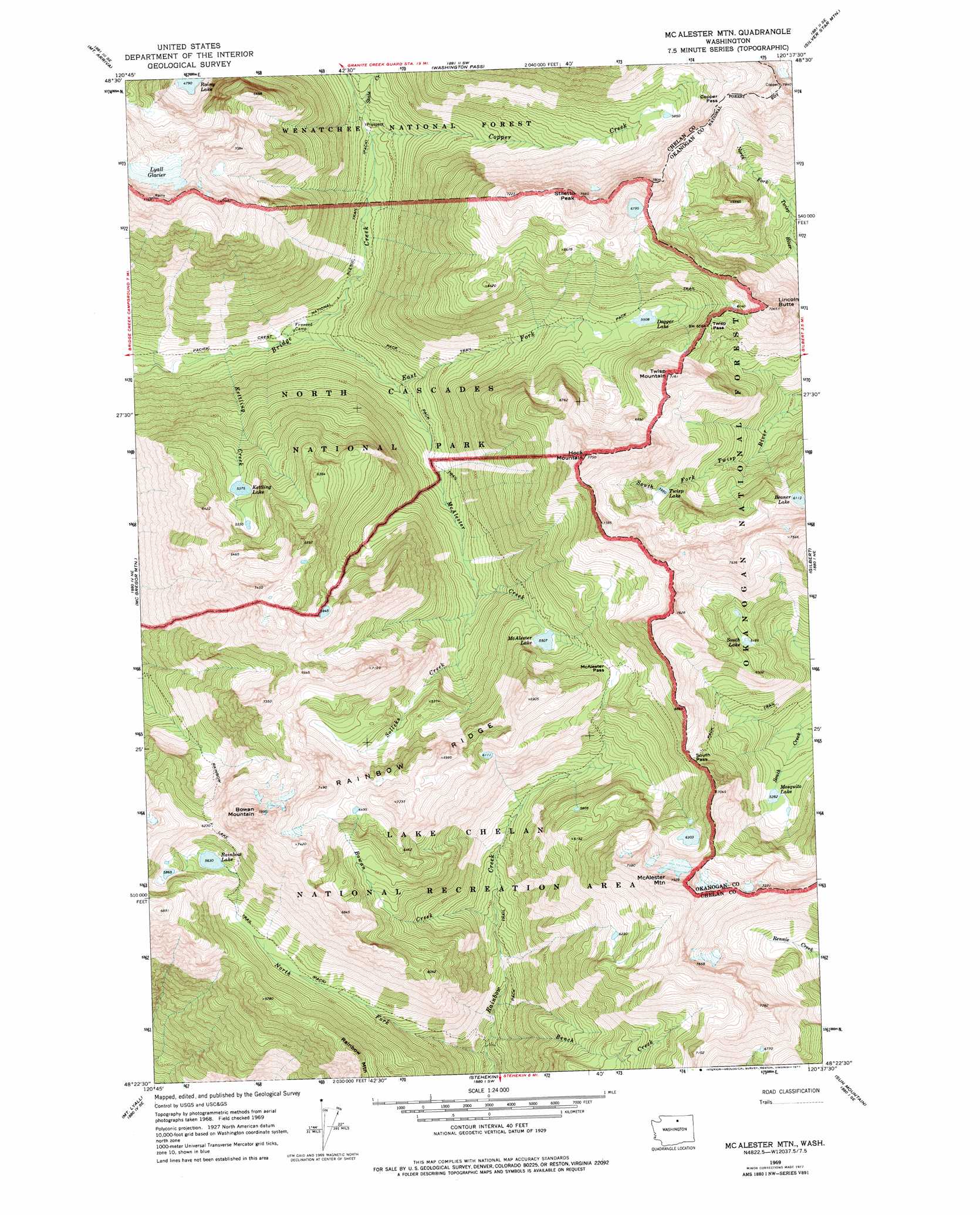
USGS Topo Quad 48120d6 - 1:24,000 scale
| Topo Map Name: | Mcalester Mountain |
| USGS Topo Quad ID: | 48120d6 |
| Print Size: | ca. 21 1/4" wide x 27" high |
| Southeast Coordinates: | 48.375° N latitude / 120.625° W longitude |
| Map Center Coordinates: | 48.4375° N latitude / 120.6875° W longitude |
| U.S. State: | WA |
| Filename: | o48120d6.jpg |
| Download Map JPG Image: | Mcalester Mountain topo map 1:24,000 scale |
| Map Type: | Topographic |
| Topo Series: | 7.5´ |
| Map Scale: | 1:24,000 |
| Source of Map Images: | United States Geological Survey (USGS) |
| Alternate Map Versions: |
Mc Alester Mtn WA 1969, updated 1973 Download PDF Buy paper map Mc Alester Mtn WA 1969, updated 1977 Download PDF Buy paper map McAlester Mountain WA 2002, updated 2006 Download PDF Buy paper map McAlester Mountain WA 2011 Download PDF Buy paper map McAlester Mountain WA 2014 Download PDF Buy paper map |
| FStopo: | US Forest Service topo McAlester Mountain is available: Download FStopo PDF Download FStopo TIF |
1:24,000 Topo Quads surrounding Mcalester Mountain
Crater Mountain |
Azurite Peak |
Slate Peak |
Robinson Mountain |
Mcleod Mountain |
Mount Logan |
Mount Arriva |
Washington Pass |
Silver Star Mountain |
Mazama |
Goode Mountain |
Mcgregor Mountain |
Mcalester Mountain |
Gilbert |
Midnight Mountain |
Agnes Mountain |
Mount Lyall |
Stehekin |
Sun Mountain |
Oval Peak |
Suiattle Pass |
Holden |
Pinnacle Mountain |
Lucerne |
Prince Creek |
> Back to 48120a1 at 1:100,000 scale
> Back to 48120a1 at 1:250,000 scale
> Back to U.S. Topo Maps home
Mcalester Mountain topo map: Gazetteer
Mcalester Mountain: Gaps
Copper Pass elevation 2028m 6653′McAlester Pass elevation 1831m 6007′
South Pass elevation 1932m 6338′
Twisp Pass elevation 1841m 6040′
Mcalester Mountain: Glaciers
Lyall Glacier elevation 2067m 6781′Mcalester Mountain: Lakes
Beaner Lake elevation 1865m 6118′Dagger Lake elevation 1681m 5515′
Kettling Lake elevation 1640m 5380′
McAlester Lake elevation 1680m 5511′
Mosquito Lake elevation 1612m 5288′
Rainbow Lake elevation 1717m 5633′
South Lake elevation 1884m 6181′
Twisp Lake elevation 1815m 5954′
Mcalester Mountain: Ridges
Rainbow Ridge elevation 2102m 6896′Mcalester Mountain: Streams
Bench Creek elevation 1124m 3687′Bowan Creek elevation 1308m 4291′
Copper Creek elevation 1275m 4183′
East Fork McAlester Creek elevation 1234m 4048′
Kettling Creek elevation 1083m 3553′
McAlester Creek elevation 1097m 3599′
North Fork Rainbow Creek elevation 1085m 3559′
Solleks Creek elevation 1421m 4662′
State Creek elevation 1283m 4209′
Mcalester Mountain: Summits
Bowan Mountain elevation 2386m 7828′Hock Mountain elevation 2306m 7565′
Lincoln Butte elevation 2147m 7043′
McAlester Mountain elevation 2406m 7893′
Stiletto Peak elevation 2277m 7470′
Twisp Mountain elevation 2144m 7034′
Mcalester Mountain: Trails
Rainbow Lake Trail elevation 1534m 5032′Mcalester Mountain digital topo map on disk
Buy this Mcalester Mountain topo map showing relief, roads, GPS coordinates and other geographical features, as a high-resolution digital map file on DVD: