Richardson Topo Map Washington
To zoom in, hover over the map of Richardson
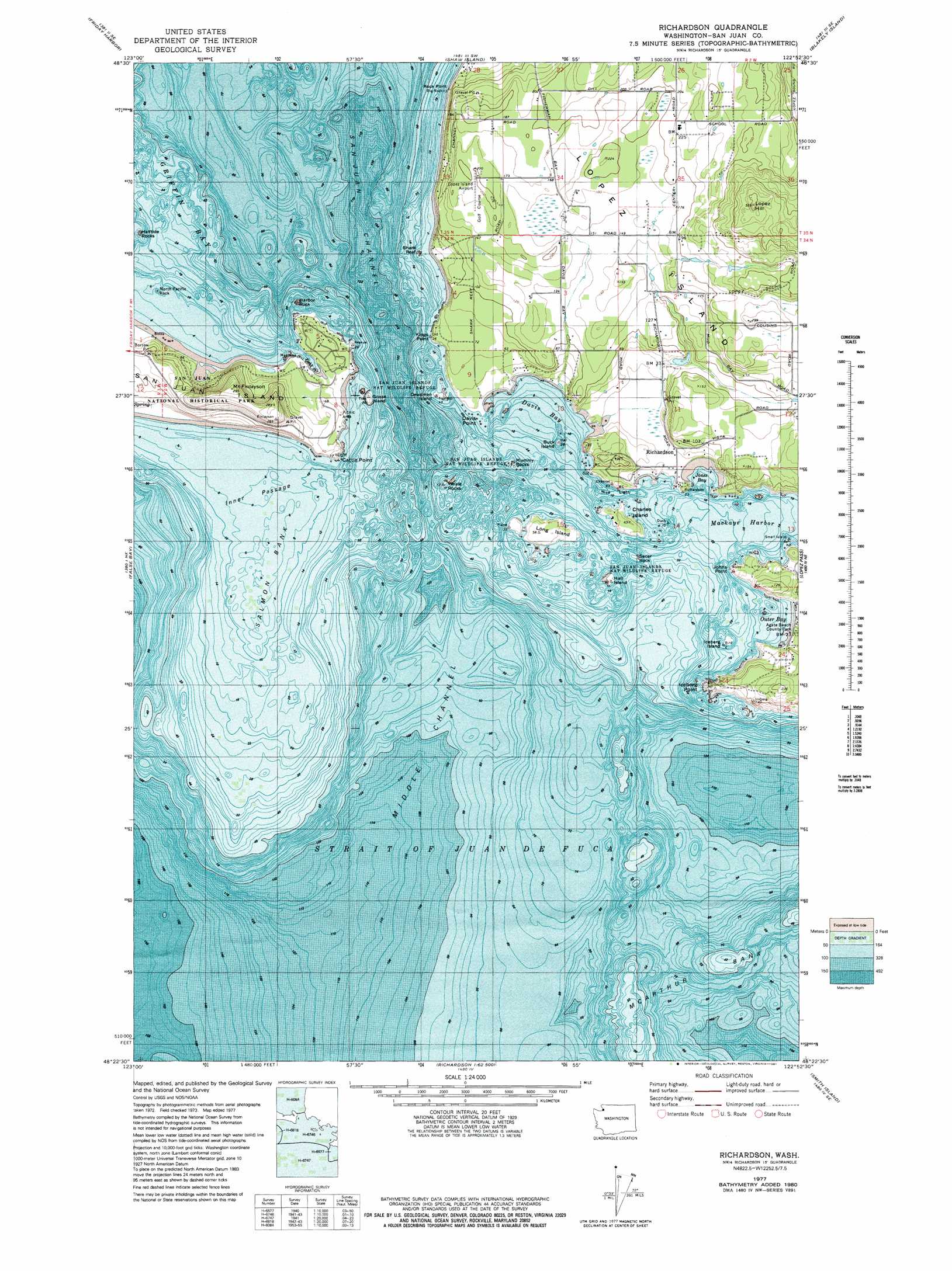
USGS Topo Quad 48122d8 - 1:24,000 scale
| Topo Map Name: | Richardson |
| USGS Topo Quad ID: | 48122d8 |
| Print Size: | ca. 21 1/4" wide x 27" high |
| Southeast Coordinates: | 48.375° N latitude / 122.875° W longitude |
| Map Center Coordinates: | 48.4375° N latitude / 122.9375° W longitude |
| U.S. State: | WA |
| Filename: | o48122d8.jpg |
| Download Map JPG Image: | Richardson topo map 1:24,000 scale |
| Map Type: | Topographic |
| Topo Series: | 7.5´ |
| Map Scale: | 1:24,000 |
| Source of Map Images: | United States Geological Survey (USGS) |
| Alternate Map Versions: |
Richardson WA 1977, updated 1978 Download PDF Buy paper map Richardson WA 1977, updated 1981 Download PDF Buy paper map Richardson WA 1998, updated 2002 Download PDF Buy paper map Richardson WA 2011 Download PDF Buy paper map Richardson WA 2014 Download PDF Buy paper map |
1:24,000 Topo Quads surrounding Richardson
Stuart Island |
Waldron Island |
Eastsound |
Mount Constitution |
Lummi Island |
Roche Harbor |
Friday Harbor |
Shaw Island |
Blakely Island |
Cypress Island |
False Bay |
Richardson |
Lopez Pass |
Deception Pass |
|
Smith Island |
Oak Harbor |
|||
Dungeness |
Port Townsend North |
Coupeville |
> Back to 48122a1 at 1:100,000 scale
> Back to 48122a1 at 1:250,000 scale
> Back to U.S. Topo Maps home
Richardson topo map: Gazetteer
Richardson: Airports
Lopez Island Airport elevation 57m 187′Richardson: Bars
Chicken Rock elevation 4m 13′Halftide Rocks elevation 0m 0′
Harbor Rock elevation 0m 0′
Hope Reef elevation 0m 0′
McArthur Bank elevation 0m 0′
North Pacific Rock elevation 0m 0′
Rock Point elevation 0m 0′
Salmon Bank elevation 0m 0′
Shark Reef elevation 0m 0′
Richardson: Bays
Davis Bay elevation 0m 0′Fish Creek elevation 5m 16′
Jakles Lagoon elevation 6m 19′
Jones Bay elevation 0m 0′
Mackaye Harbor elevation 0m 0′
Mya Cove elevation 0m 0′
Outer Bay elevation 0m 0′
Rowboat Cove elevation 15m 49′
Third Lagoon elevation 3m 9′
Richardson: Capes
Cattle Point elevation 12m 39′Davis Point elevation 0m 0′
Iceberg Point elevation 8m 26′
Johns Point elevation 12m 39′
Kings Point elevation 14m 45′
Richardson: Channels
Inner Passage elevation 0m 0′Middle Channel elevation 0m 0′
Richardson: Cliffs
White Cliffs elevation 0m 0′Richardson: Dams
Duroucher Dam elevation 62m 203′Goodrow Dam elevation 26m 85′
Oberholtzer Dam elevation 51m 167′
Richardson: Islands
Buck Island elevation 0m 0′Charles Island elevation 15m 49′
Deadman Island elevation 4m 13′
Geese Islets elevation 10m 32′
Goose Island elevation 4m 13′
Hall Island elevation 5m 16′
Iceberg Island elevation 0m 0′
Iowa Rock elevation 0m 0′
Long Island elevation 18m 59′
Lopez Island elevation 87m 285′
Mummy Rocks elevation 0m 0′
Richardson Rock elevation 0m 0′
Secar Rock elevation 0m 0′
Whale Rocks elevation 0m 0′
Richardson: Parks
Agate Beach County Park elevation 12m 39′Iceberg Island State Marine Park elevation 0m 0′
San Juan Island National Historical Park elevation 35m 114′
Richardson: Populated Places
Richardson elevation 17m 55′Richardson: Seas
Northwest Straits elevation 0m 0′Richardson: Summits
Lopez Hill elevation 148m 485′Mount Finlayson elevation 90m 295′
Richardson digital topo map on disk
Buy this Richardson topo map showing relief, roads, GPS coordinates and other geographical features, as a high-resolution digital map file on DVD: