Ferndale Topo Map Washington
To zoom in, hover over the map of Ferndale
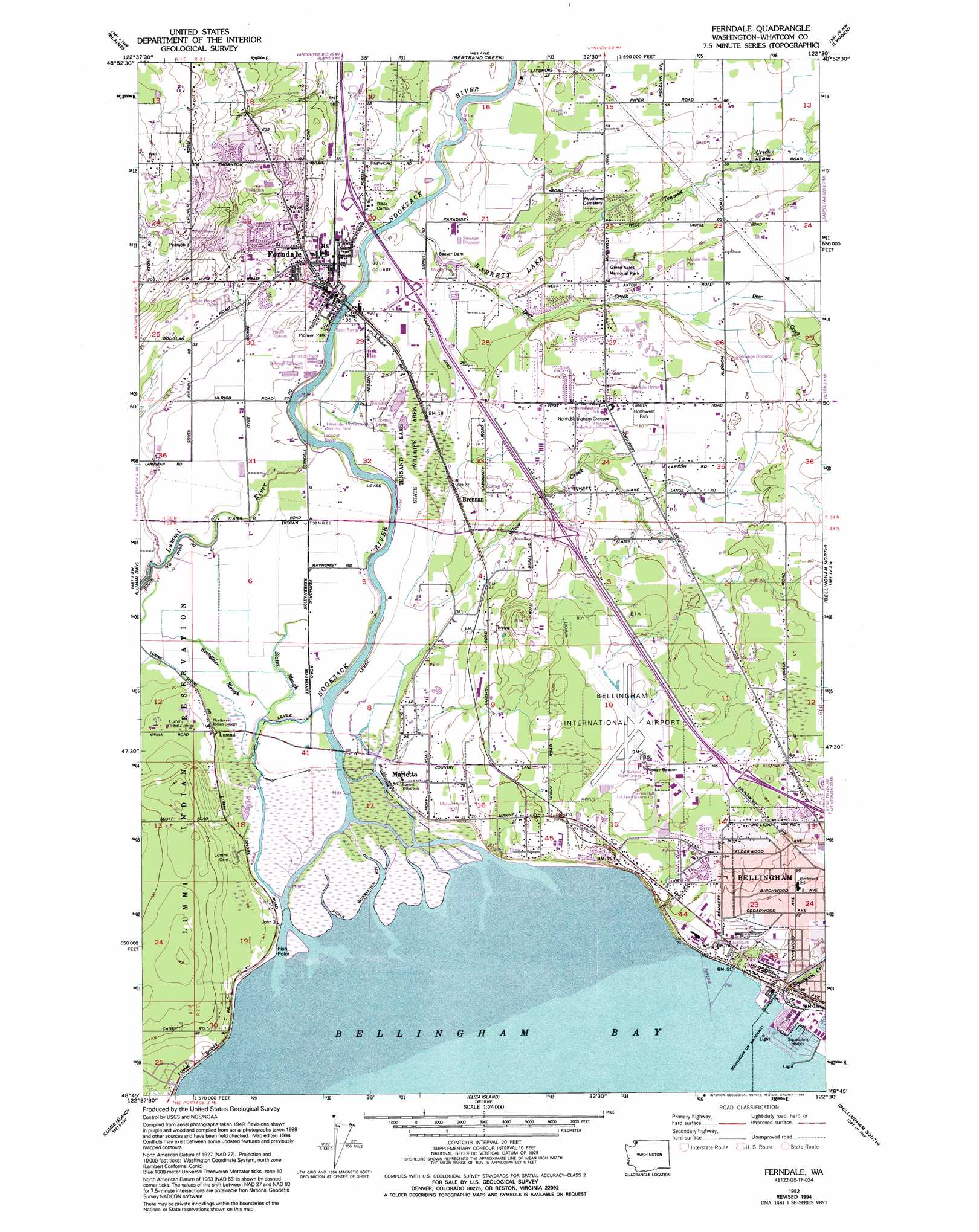
USGS Topo Quad 48122g5 - 1:24,000 scale
| Topo Map Name: | Ferndale |
| USGS Topo Quad ID: | 48122g5 |
| Print Size: | ca. 21 1/4" wide x 27" high |
| Southeast Coordinates: | 48.75° N latitude / 122.5° W longitude |
| Map Center Coordinates: | 48.8125° N latitude / 122.5625° W longitude |
| U.S. State: | WA |
| Filename: | o48122g5.jpg |
| Download Map JPG Image: | Ferndale topo map 1:24,000 scale |
| Map Type: | Topographic |
| Topo Series: | 7.5´ |
| Map Scale: | 1:24,000 |
| Source of Map Images: | United States Geological Survey (USGS) |
| Alternate Map Versions: |
Ferndale WA 1952, updated 1957 Download PDF Buy paper map Ferndale WA 1952, updated 1973 Download PDF Buy paper map Ferndale WA 1952, updated 1994 Download PDF Buy paper map Ferndale WA 1952, updated 1994 Download PDF Buy paper map Ferndale WA 2011 Download PDF Buy paper map Ferndale WA 2014 Download PDF Buy paper map |
1:24,000 Topo Quads surrounding Ferndale
Birch Point |
Blaine |
Bertrand Creek |
Lynden |
Sumas |
Lummi Bay |
Ferndale |
Bellingham North |
Lawrence |
|
Mount Constitution |
Lummi Island |
Eliza Island |
Bellingham South |
Lake Whatcom |
Blakely Island |
Cypress Island |
Anacortes North |
Bow |
Alger |
> Back to 48122e1 at 1:100,000 scale
> Back to 48122a1 at 1:250,000 scale
> Back to U.S. Topo Maps home
Ferndale topo map: Gazetteer
Ferndale: Airports
Bellingham International Airport elevation 49m 160′Ferndale: Canals
Schell Ditch elevation 3m 9′Ferndale: Capes
Fish Point elevation 2m 6′Ferndale: Channels
Squalicum Waterway elevation 0m 0′Ferndale: Crossings
Bakerview Interchange elevation 56m 183′North Ferndale Interchange elevation 11m 36′
Northwest Avenue Interchange elevation 45m 147′
South Ferndale Interchange elevation 10m 32′
Ferndale: Dams
Nubgaard Dam Number One elevation 91m 298′Nubgaard Dam Number Two elevation 89m 291′
Taylor Pond Dam elevation 31m 101′
Ferndale: Lakes
Tennant Lake elevation 7m 22′Ferndale: Parks
Hovander Homestead Park elevation 8m 26′Pioneer Park elevation 8m 26′
Tenwent Lake State Wildlife Recreation Area elevation 7m 22′
Ferndale: Populated Places
Alderwood elevation 46m 150′Birchwood elevation 27m 88′
Brennan elevation 20m 65′
Ferndale elevation 11m 36′
Lummi elevation 9m 29′
Marietta elevation 3m 9′
Ferndale: Reservoirs
Barrett Lake elevation 7m 22′Brennan Pond elevation 5m 16′
Taylor Pond elevation 31m 101′
Ferndale: Streams
Deer Creek elevation 8m 26′Nooksack River elevation 1m 3′
Silver Creek elevation 3m 9′
Slater Slough elevation 3m 9′
Smuggler Slough elevation 3m 9′
Squalicum Creek elevation 5m 16′
Tenmile Creek elevation 7m 22′
Ferndale digital topo map on disk
Buy this Ferndale topo map showing relief, roads, GPS coordinates and other geographical features, as a high-resolution digital map file on DVD: