Munson Topo Map Florida
To zoom in, hover over the map of Munson
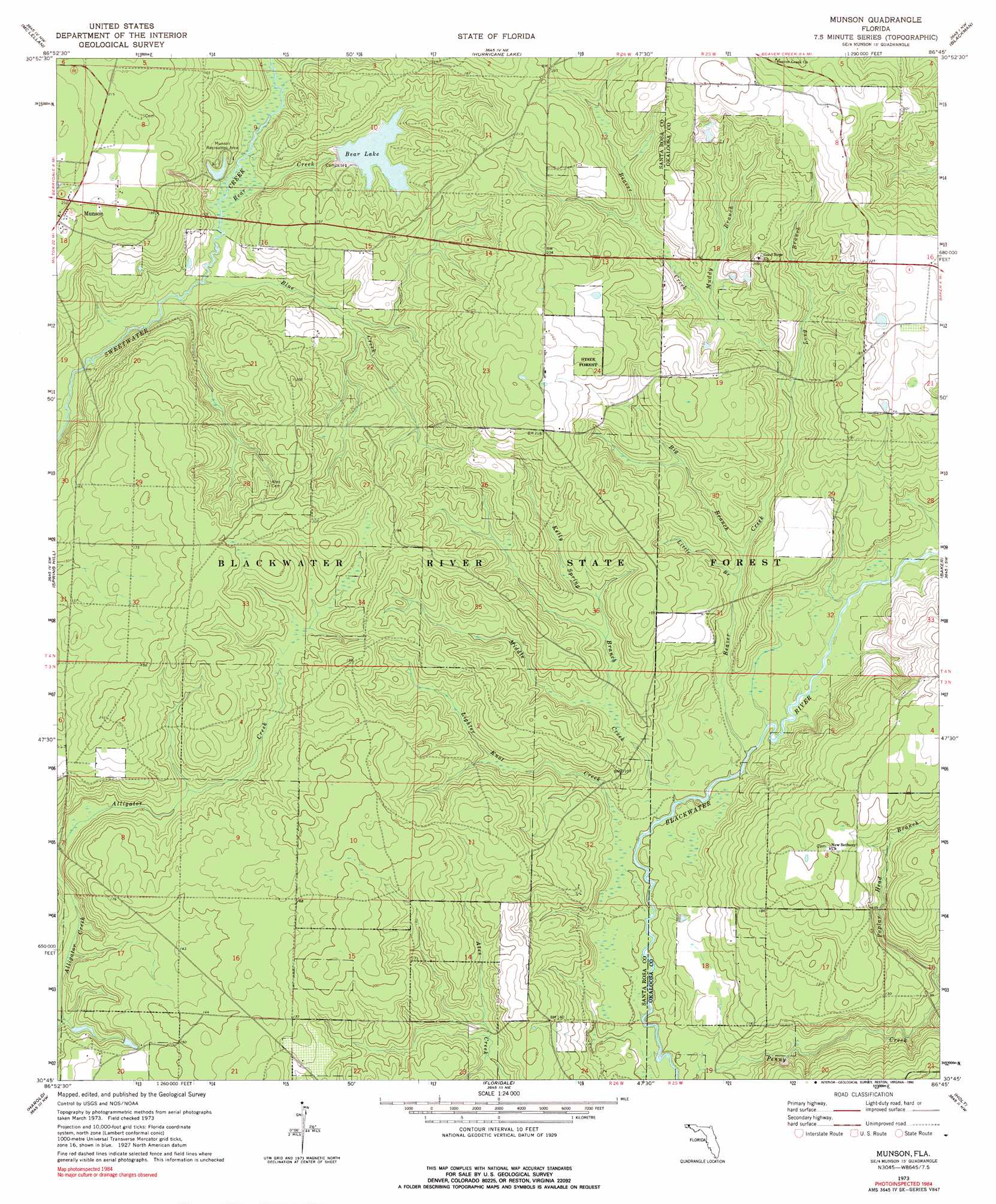
USGS Topo Quad 30086g7 - 1:24,000 scale
| Topo Map Name: | Munson |
| USGS Topo Quad ID: | 30086g7 |
| Print Size: | ca. 21 1/4" wide x 27" high |
| Southeast Coordinates: | 30.75° N latitude / 86.75° W longitude |
| Map Center Coordinates: | 30.8125° N latitude / 86.8125° W longitude |
| U.S. State: | FL |
| Filename: | O30086G7.jpg |
| Download Map JPG Image: | Munson topo map 1:24,000 scale |
| Map Type: | Topographic |
| Topo Series: | 7.5´ |
| Map Scale: | 1:24,000 |
| Source of Map Images: | United States Geological Survey (USGS) |
| Alternate Map Versions: |
Munson FL 1973, updated 1976 Download PDF Buy paper map Munson FL 1973, updated 1990 Download PDF Buy paper map Munson FL 1973, updated 1990 Download PDF Buy paper map Munson FL 2012 Download PDF Buy paper map Munson FL 2015 Download PDF Buy paper map |
1:24,000 Topo Quads surrounding Munson
Brewton South |
Roberts |
Parker Springs |
Bradley |
Wing |
Fidelis |
Mclellan |
Hurricane Lake |
Blackman |
Oak Grove |
Allentown |
Spring Hill |
Munson |
Baker |
Crestview North |
Milton North |
Harold |
Floridale |
Holt |
Crestview South |
Milton South |
Ward Basin |
Harold Se |
Holt Sw |
Valparaiso |
> Back to 30086e1 at 1:100,000 scale
> Back to 30086a1 at 1:250,000 scale
> Back to U.S. Topo Maps home
Munson topo map: Gazetteer
Munson: Lakes
Martins Mill Pond elevation 51m 167′Munson: Parks
Blackwater Wildlife Management Area elevation 40m 131′Munson Recreation Area elevation 33m 108′
Munson: Populated Places
Munson elevation 64m 209′Munson: Reservoirs
Bear Lake elevation 36m 118′Munson: Streams
Bear Creek elevation 22m 72′Beaver Creek elevation 15m 49′
Big Branch Beaver Creek elevation 24m 78′
Blue Creek elevation 21m 68′
Kelly Spring Branch elevation 24m 78′
Lighter Knot Creek elevation 15m 49′
Little Branch Beaver Creek elevation 24m 78′
Long Branch elevation 31m 101′
Middle Creek elevation 15m 49′
Muddy Branch elevation 35m 114′
Poplar Head Branch elevation 24m 78′
Munson digital topo map on disk
Buy this Munson topo map showing relief, roads, GPS coordinates and other geographical features, as a high-resolution digital map file on DVD:
Gulf Coast (LA, MS, AL, FL) & Southwestern Georgia
Buy digital topo maps: Gulf Coast (LA, MS, AL, FL) & Southwestern Georgia
 & Southwestern Georgia map DVD")