Pluck Topo Map Texas
To zoom in, hover over the map of Pluck
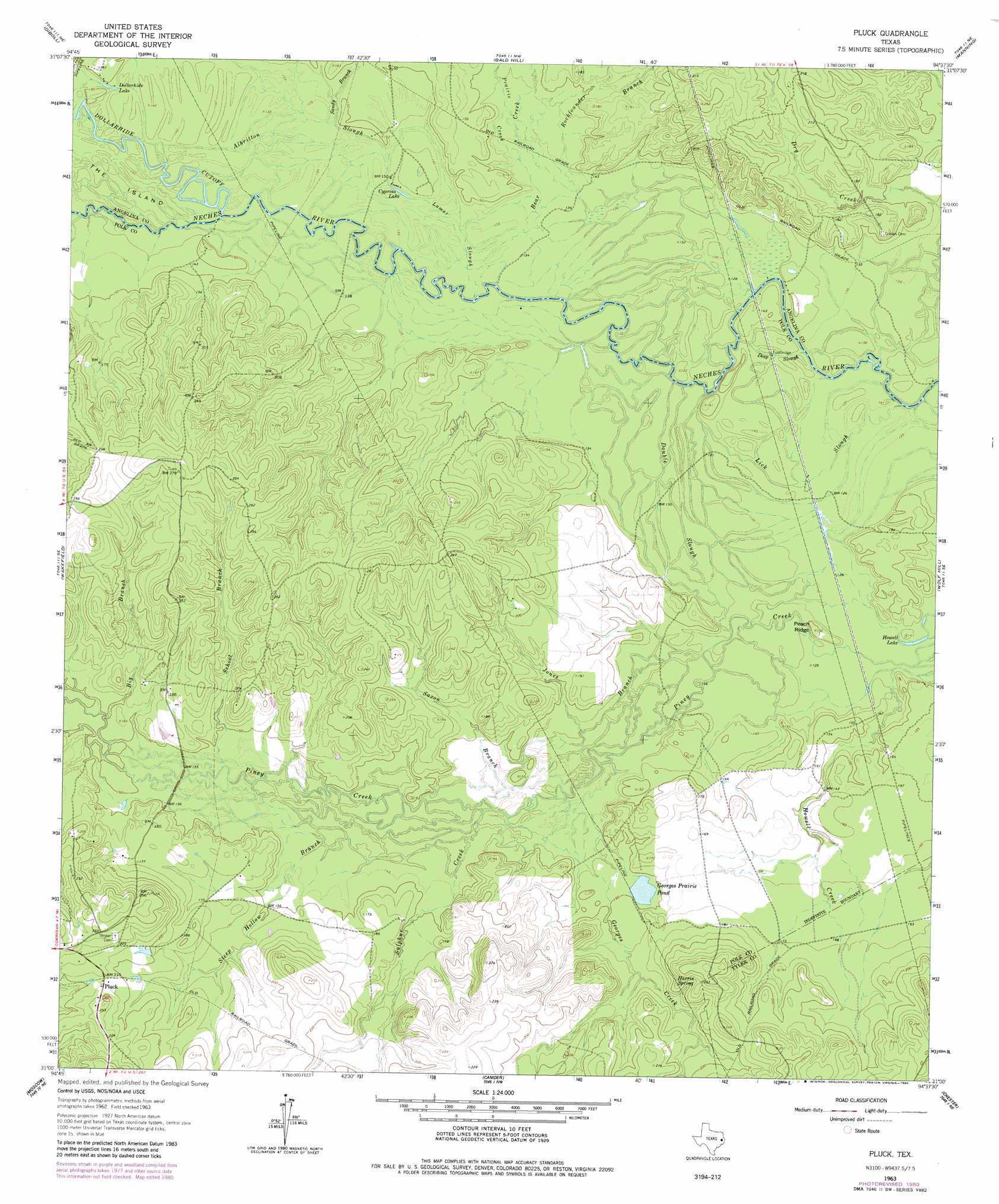
USGS Topo Quad 31094a6 - 1:24,000 scale
| Topo Map Name: | Pluck |
| USGS Topo Quad ID: | 31094a6 |
| Print Size: | ca. 21 1/4" wide x 27" high |
| Southeast Coordinates: | 31° N latitude / 94.625° W longitude |
| Map Center Coordinates: | 31.0625° N latitude / 94.6875° W longitude |
| U.S. State: | TX |
| Filename: | o31094a6.jpg |
| Download Map JPG Image: | Pluck topo map 1:24,000 scale |
| Map Type: | Topographic |
| Topo Series: | 7.5´ |
| Map Scale: | 1:24,000 |
| Source of Map Images: | United States Geological Survey (USGS) |
| Alternate Map Versions: |
Lufkin 4-c TX 1927 Download PDF Buy paper map Pluck TX 1963, updated 1966 Download PDF Buy paper map Pluck TX 1963, updated 1980 Download PDF Buy paper map Pluck TX 2010 Download PDF Buy paper map Pluck TX 2013 Download PDF Buy paper map Pluck TX 2016 Download PDF Buy paper map |
1:24,000 Topo Quads surrounding Pluck
Wells Sw |
Keltys |
Lufkin |
Huntington |
Etoile South |
Apple Springs |
Diboll |
Bald Hill |
Manning |
Zavalla |
Trevat |
Wakefield |
Pluck |
Wolf Hill |
Rockland |
Carmona |
Corrigan |
Camden |
Chester |
Colmesneil |
New Willard |
Leggett |
Hortense |
Chambliss Hill |
Woodville |
> Back to 31094a1 at 1:100,000 scale
> Back to 31094a1 at 1:250,000 scale
> Back to U.S. Topo Maps home
Pluck topo map: Gazetteer
Pluck: Guts
Albritton Slough elevation 41m 134′Deep Slough elevation 40m 131′
Double Slough elevation 40m 131′
Lamar Slough elevation 41m 134′
Lick Slough elevation 39m 127′
Pluck: Lakes
Cypress Lake elevation 42m 137′Dollarhide Lake elevation 43m 141′
Georges Prairie Pond elevation 44m 144′
Howell Lake elevation 38m 124′
Pluck: Populated Places
Pluck elevation 64m 209′Pluck: Ridges
Peach Ridge elevation 47m 154′Pluck: Springs
Harris Spring elevation 66m 216′Pluck: Streams
Bear Creek elevation 39m 127′Big Branch elevation 46m 150′
Georges Creek elevation 40m 131′
Jones Branch elevation 40m 131′
Prairie Creek elevation 41m 134′
Rockfounder Branch elevation 38m 124′
Sandy Branch elevation 43m 141′
Saxon Branch elevation 43m 141′
School Branch elevation 44m 144′
Steep Hollow Branch elevation 43m 141′
Sulphur Creek elevation 43m 141′
Pluck digital topo map on disk
Buy this Pluck topo map showing relief, roads, GPS coordinates and other geographical features, as a high-resolution digital map file on DVD: