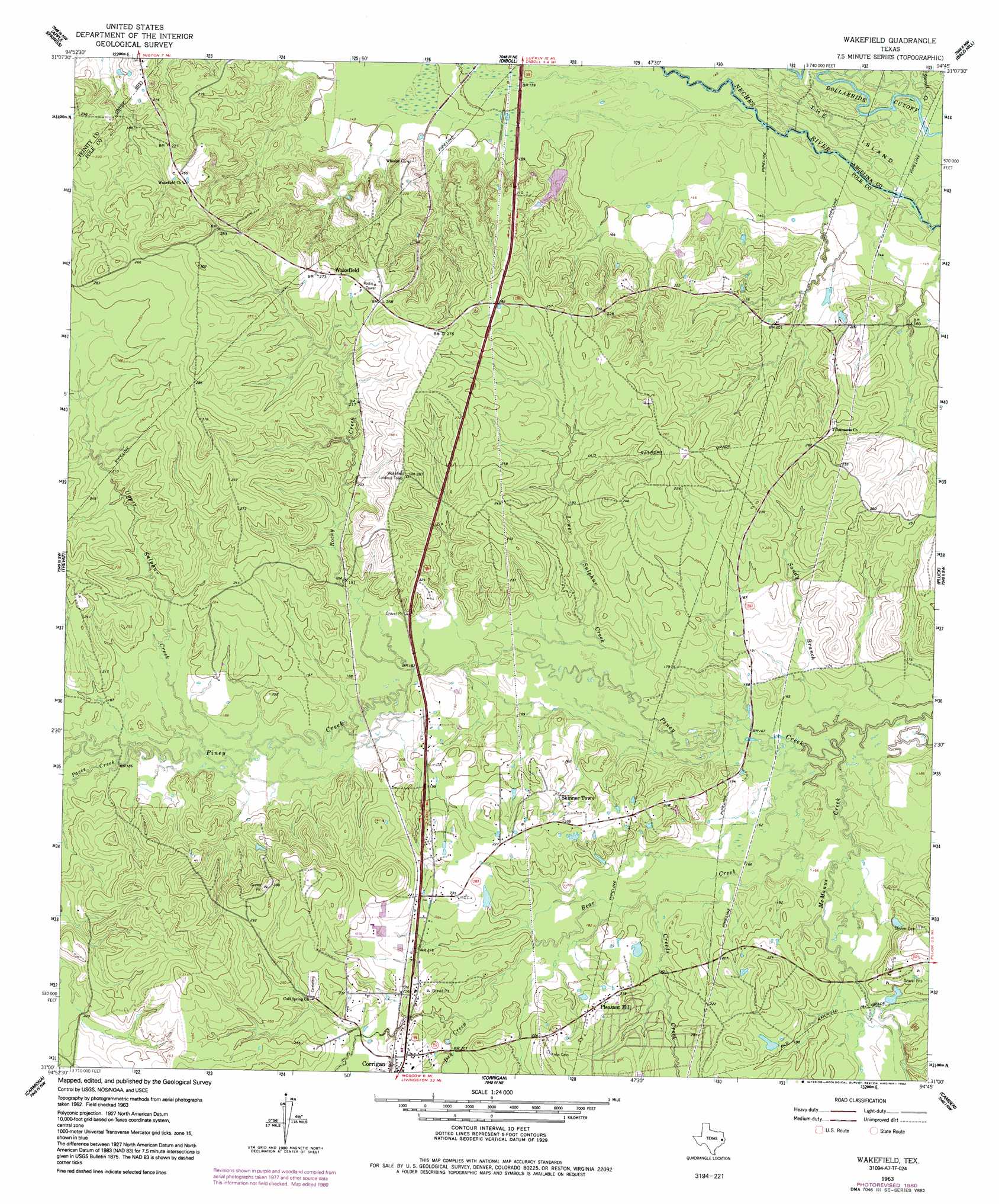
Wakefield Topo Map Texas
To zoom in, hover over the map of Wakefield
USGS Topo Quad 31094a7 - 1:24,000 scale
| Topo Map Name: | Wakefield |
| USGS Topo Quad ID: | 31094a7 |
| Print Size: | ca. 21 1/4" wide x 27" high |
| Southeast Coordinates: | 31° N latitude / 94.75° W longitude |
| Map Center Coordinates: | 31.0625° N latitude / 94.8125° W longitude |
| U.S. State: | TX |
| Filename: | o31094a7.jpg |
| Download Map JPG Image: | Wakefield topo map 1:24,000 scale |
| Map Type: | Topographic |
| Topo Series: | 7.5´ |
| Map Scale: | 1:24,000 |
| Source of Map Images: | United States Geological Survey (USGS) |
| Alternate Map Versions: |
Lufkin 3-d TX 1928 Download PDF Buy paper map Wakefield TX 1963, updated 1966 Download PDF Buy paper map Wakefield TX 1963, updated 1980 Download PDF Buy paper map Wakefield TX 1963, updated 1992 Download PDF Buy paper map Wakefield TX 2010 Download PDF Buy paper map Wakefield TX 2013 Download PDF Buy paper map Wakefield TX 2016 Download PDF Buy paper map |
1:24,000 Topo Quads surrounding Wakefield
Centralia |
Wells Sw |
Keltys |
Lufkin |
Huntington |
Crecy |
Apple Springs |
Diboll |
Bald Hill |
Manning |
Groveton East |
Trevat |
Wakefield |
Pluck |
Wolf Hill |
Colita |
Carmona |
Corrigan |
Camden |
Chester |
Onalaska |
New Willard |
Leggett |
Hortense |
Chambliss Hill |
> Back to 31094a1 at 1:100,000 scale
> Back to 31094a1 at 1:250,000 scale
> Back to U.S. Topo Maps home
Wakefield topo map: Gazetteer
Wakefield: Guts
Dollarhide Cutoff elevation 43m 141′Wakefield: Islands
The Island elevation 43m 141′The Island elevation 43m 141′
Wakefield: Populated Places
Pleasant Hill elevation 71m 232′Skinner Town elevation 61m 200′
Wakefield elevation 85m 278′
Wakefield: Streams
Bear Creek elevation 46m 150′Creeds Creek elevation 52m 170′
Dry Creek elevation 58m 190′
Lower Sulphur Creek elevation 49m 160′
McManus Creek elevation 46m 150′
Paces Creek elevation 53m 173′
Rocky Creek elevation 52m 170′
Sandy Branch elevation 46m 150′
Stovall Creek elevation 43m 141′
Stovall Creek elevation 43m 141′
Upper Sulphur Creek elevation 53m 173′
Wakefield digital topo map on disk
Buy this Wakefield topo map showing relief, roads, GPS coordinates and other geographical features, as a high-resolution digital map file on DVD: