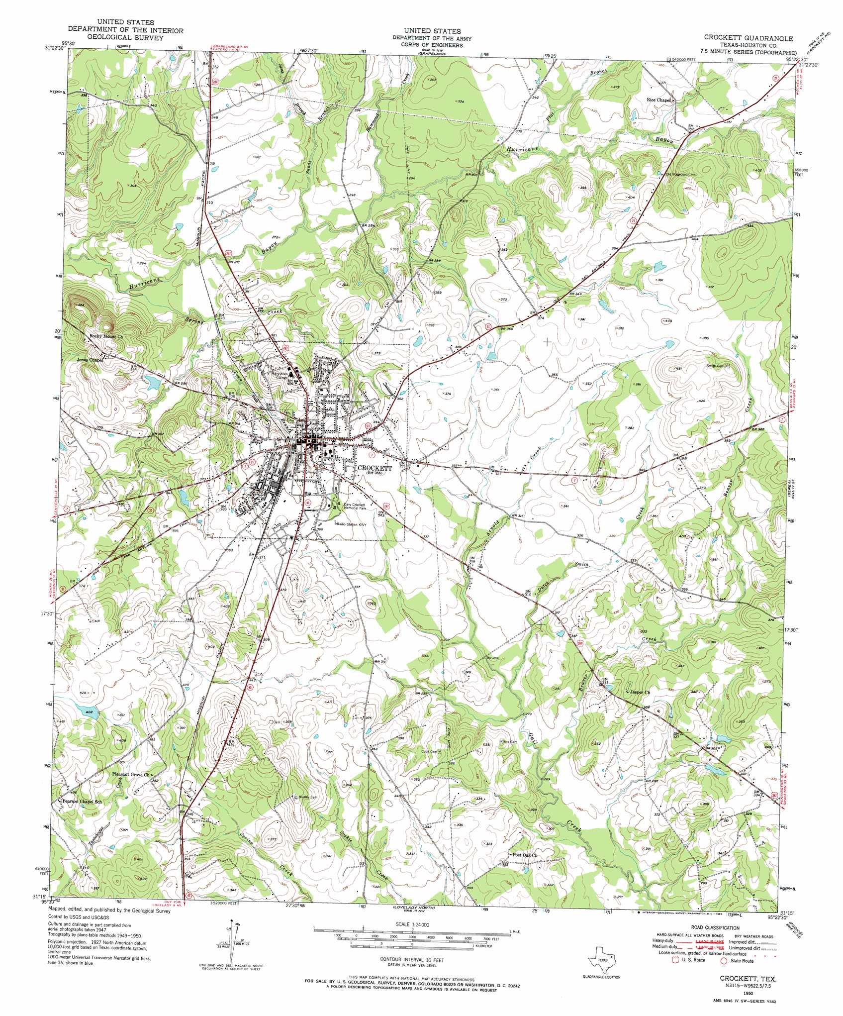
Crockett Topo Map Texas
To zoom in, hover over the map of Crockett
USGS Topo Quad 31095c4 - 1:24,000 scale
| Topo Map Name: | Crockett |
| USGS Topo Quad ID: | 31095c4 |
| Print Size: | ca. 21 1/4" wide x 27" high |
| Southeast Coordinates: | 31.25° N latitude / 95.375° W longitude |
| Map Center Coordinates: | 31.3125° N latitude / 95.4375° W longitude |
| U.S. State: | TX |
| Filename: | o31095c4.jpg |
| Download Map JPG Image: | Crockett topo map 1:24,000 scale |
| Map Type: | Topographic |
| Topo Series: | 7.5´ |
| Map Scale: | 1:24,000 |
| Source of Map Images: | United States Geological Survey (USGS) |
| Alternate Map Versions: |
Crockett TX 1950, updated 1965 Download PDF Buy paper map Crockett TX 1951 Download PDF Buy paper map Crockett TX 2010 Download PDF Buy paper map Crockett TX 2013 Download PDF Buy paper map Crockett TX 2016 Download PDF Buy paper map |
1:24,000 Topo Quads surrounding Crockett
Indian Lake |
Elkhart Creek |
Percilla |
Augusta |
Weches |
Stanmire Lake |
Hays Spring |
Grapeland |
Crockett Ne |
Ratcliff |
Halls Bluff |
Porter Springs |
Crockett |
Berea |
Kennard |
Austonio |
Pearsons Chapel |
Lovelady North |
Fodice |
Pennington |
Sand Ridge |
Weldon |
Lovelady South |
Glendale |
Groveton West |
> Back to 31095a1 at 1:100,000 scale
> Back to 31094a1 at 1:250,000 scale
> Back to U.S. Topo Maps home
Crockett topo map: Gazetteer
Crockett: Airports
Houston County Airport elevation 103m 337′Houston County Hospital/Kings Inn Heliport elevation 113m 370′
Crockett: Dams
Allday Dam elevation 119m 390′Cook Dam elevation 92m 301′
Northcutt Lake Dam elevation 95m 311′
Traylor Dam elevation 95m 311′
Crockett: Lakes
Cooks Lake elevation 96m 314′Crockett: Parks
Davy Crockett Memorial Park elevation 107m 351′Evergreen Memorial Park elevation 92m 301′
Crockett: Populated Places
Crockett elevation 111m 364′Druso elevation 118m 387′
Nottingham Woods elevation 103m 337′
Crockett: Reservoirs
Allday Lake elevation 119m 390′Cook Lake elevation 92m 301′
Northcutt Lake elevation 95m 311′
Traylor Lake elevation 95m 311′
Crockett: Streams
Arnold Creek elevation 89m 291′Beaver Creek elevation 82m 269′
Dutch Smith Creek elevation 86m 282′
Flat Branch elevation 95m 311′
Hammond Creek elevation 85m 278′
Sands Branch elevation 83m 272′
Sims Branch elevation 94m 308′
Spring Creek elevation 76m 249′
Town Branch elevation 81m 265′
Crockett digital topo map on disk
Buy this Crockett topo map showing relief, roads, GPS coordinates and other geographical features, as a high-resolution digital map file on DVD: