Sand Ridge Topo Map Texas
To zoom in, hover over the map of Sand Ridge
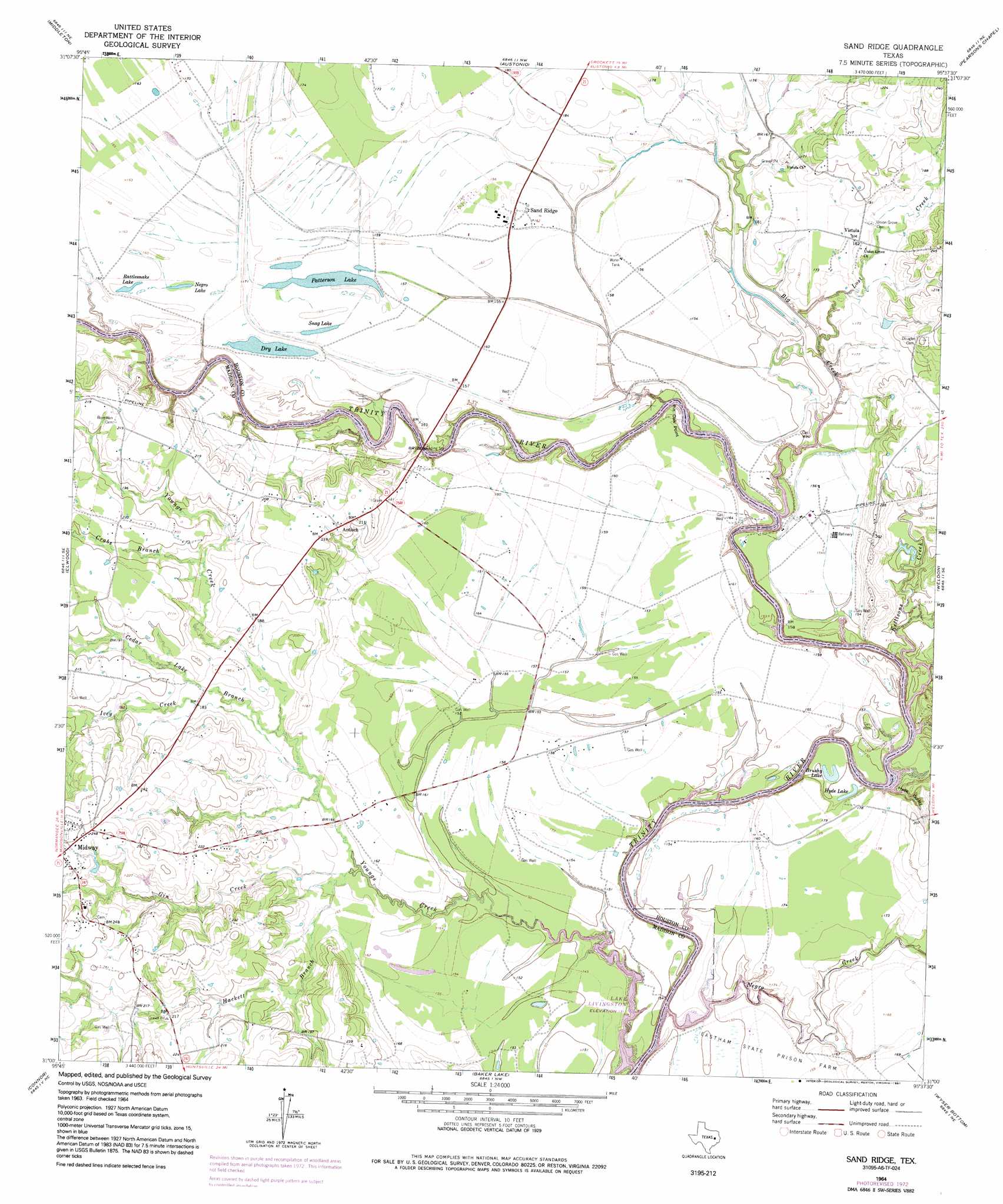
USGS Topo Quad 31095a6 - 1:24,000 scale
| Topo Map Name: | Sand Ridge |
| USGS Topo Quad ID: | 31095a6 |
| Print Size: | ca. 21 1/4" wide x 27" high |
| Southeast Coordinates: | 31° N latitude / 95.625° W longitude |
| Map Center Coordinates: | 31.0625° N latitude / 95.6875° W longitude |
| U.S. State: | TX |
| Filename: | o31095a6.jpg |
| Download Map JPG Image: | Sand Ridge topo map 1:24,000 scale |
| Map Type: | Topographic |
| Topo Series: | 7.5´ |
| Map Scale: | 1:24,000 |
| Source of Map Images: | United States Geological Survey (USGS) |
| Alternate Map Versions: |
Sand Ridge TX 1964, updated 1967 Download PDF Buy paper map Sand Ridge TX 1964, updated 1974 Download PDF Buy paper map Sand Ridge TX 1964, updated 1991 Download PDF Buy paper map Sand Ridge TX 2010 Download PDF Buy paper map Sand Ridge TX 2013 Download PDF Buy paper map Sand Ridge TX 2016 Download PDF Buy paper map |
1:24,000 Topo Quads surrounding Sand Ridge
Centerville |
Eunice |
Halls Bluff |
Porter Springs |
Crockett |
Leona |
Middleton |
Austonio |
Pearsons Chapel |
Lovelady North |
Leona Sw |
Elwood |
Sand Ridge |
Weldon |
Lovelady South |
Madisonville |
Connor |
Baker Lake |
Wyser Bottom |
Trinity West |
Bedias |
Steep Branch |
Crabbs Prairie |
Pine Prairie |
Riverside |
> Back to 31095a1 at 1:100,000 scale
> Back to 31094a1 at 1:250,000 scale
> Back to U.S. Topo Maps home
Sand Ridge topo map: Gazetteer
Sand Ridge: Capes
Pin Oak Point elevation 40m 131′Sand Ridge: Crossings
Hydes Ferry (historical) elevation 40m 131′Sand Ridge: Lakes
Brushy Lake elevation 44m 144′Dry Lake elevation 46m 150′
Hyde Lake elevation 47m 154′
Negro Lake elevation 48m 157′
Patterson Lake elevation 46m 150′
Rattlesnake Lake elevation 49m 160′
Snag Lake elevation 47m 154′
Sand Ridge: Populated Places
Antioch elevation 66m 216′Sand Ridge elevation 50m 164′
Vistula elevation 55m 180′
Sand Ridge: Streams
Big Creek elevation 40m 131′Cedar Lake Branch elevation 48m 157′
Crabs Branch elevation 53m 173′
Gin Creek elevation 46m 150′
Hackett Branch elevation 46m 150′
Ivey Creek elevation 48m 157′
Kellisons Creek elevation 40m 131′
Lost Creek elevation 43m 141′
Negro Creek elevation 40m 131′
Youngs Creek elevation 40m 131′
Sand Ridge: Valleys
Hyde Gulley elevation 40m 131′Sand Ridge digital topo map on disk
Buy this Sand Ridge topo map showing relief, roads, GPS coordinates and other geographical features, as a high-resolution digital map file on DVD: