Porter Springs Topo Map Texas
To zoom in, hover over the map of Porter Springs
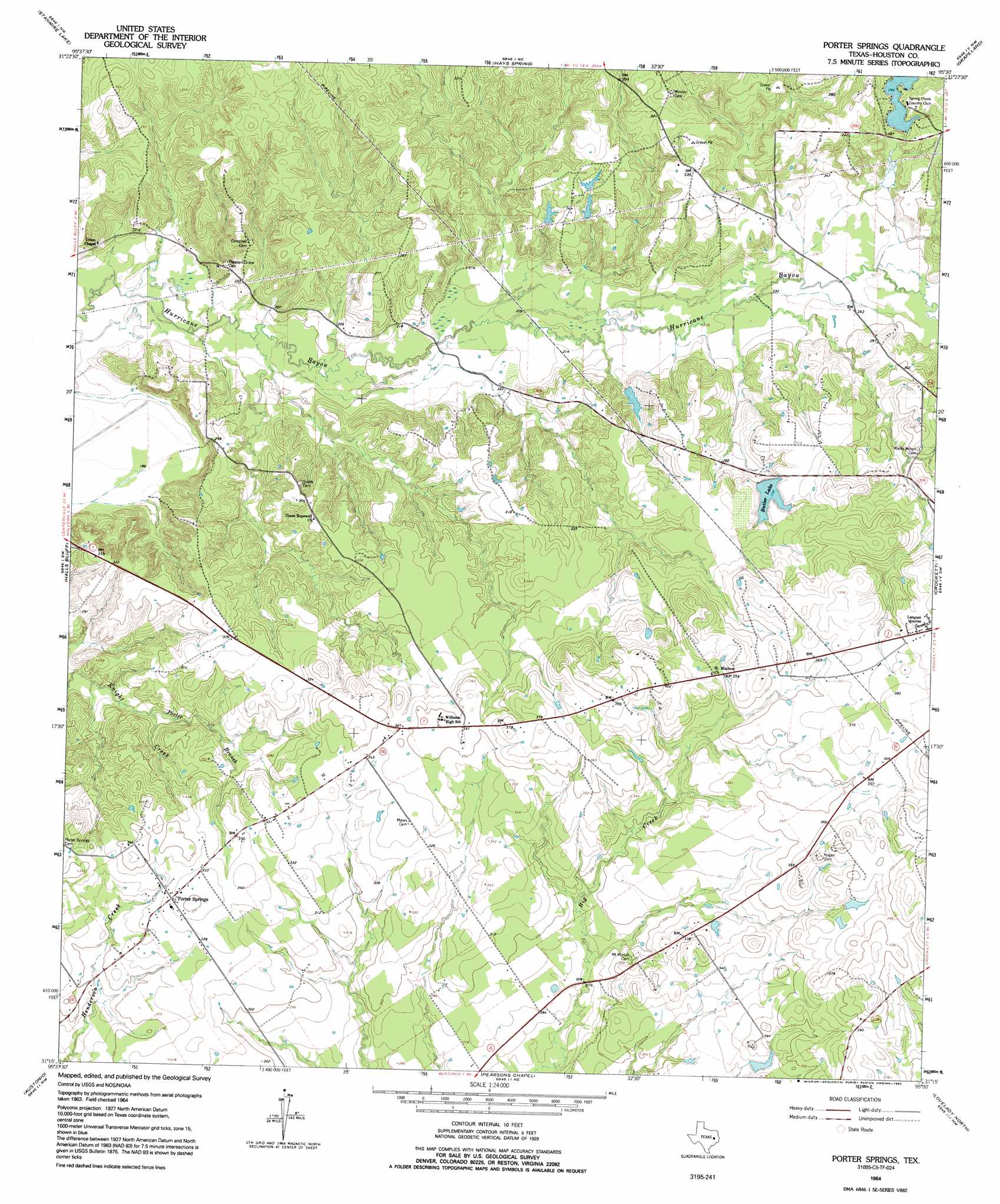
USGS Topo Quad 31095c5 - 1:24,000 scale
| Topo Map Name: | Porter Springs |
| USGS Topo Quad ID: | 31095c5 |
| Print Size: | ca. 21 1/4" wide x 27" high |
| Southeast Coordinates: | 31.25° N latitude / 95.5° W longitude |
| Map Center Coordinates: | 31.3125° N latitude / 95.5625° W longitude |
| U.S. State: | TX |
| Filename: | o31095c5.jpg |
| Download Map JPG Image: | Porter Springs topo map 1:24,000 scale |
| Map Type: | Topographic |
| Topo Series: | 7.5´ |
| Map Scale: | 1:24,000 |
| Source of Map Images: | United States Geological Survey (USGS) |
| Alternate Map Versions: |
Porter Springs TX 1964, updated 1967 Download PDF Buy paper map Porter Springs TX 1964, updated 1992 Download PDF Buy paper map Porter Springs TX 2010 Download PDF Buy paper map Porter Springs TX 2013 Download PDF Buy paper map Porter Springs TX 2016 Download PDF Buy paper map |
1:24,000 Topo Quads surrounding Porter Springs
Oakwood |
Indian Lake |
Elkhart Creek |
Percilla |
Augusta |
Lake Leon |
Stanmire Lake |
Hays Spring |
Grapeland |
Crockett Ne |
Eunice |
Halls Bluff |
Porter Springs |
Crockett |
Berea |
Middleton |
Austonio |
Pearsons Chapel |
Lovelady North |
Fodice |
Elwood |
Sand Ridge |
Weldon |
Lovelady South |
Glendale |
> Back to 31095a1 at 1:100,000 scale
> Back to 31094a1 at 1:250,000 scale
> Back to U.S. Topo Maps home
Porter Springs topo map: Gazetteer
Porter Springs: Airports
M Y Ranch Airport elevation 91m 298′Porter Springs: Areas
Mustang Prairie elevation 85m 278′Porter Springs: Dams
Edmiston Dam elevation 89m 291′Skalicky Dam elevation 84m 275′
Spring Creek Country Club Lake Dam elevation 91m 298′
Wirt Lake Dam elevation 77m 252′
Porter Springs: Populated Places
Porter Springs elevation 103m 337′Porter Springs: Post Offices
Aldrich Post Office elevation 128m 419′Porter Springs: Reservoirs
Butler Lake elevation 91m 298′Skalicky Lake elevation 84m 275′
Spring Creek Country Club Lake elevation 91m 298′
Wirt Lake elevation 77m 252′
Porter Springs: Streams
Dan Jenkins Creek elevation 61m 200′Porter Branch elevation 69m 226′
Salt Branch Creek elevation 59m 193′
Spring Creek elevation 84m 275′
Porter Springs: Summits
Gary Hill elevation 77m 252′Porter Springs digital topo map on disk
Buy this Porter Springs topo map showing relief, roads, GPS coordinates and other geographical features, as a high-resolution digital map file on DVD: