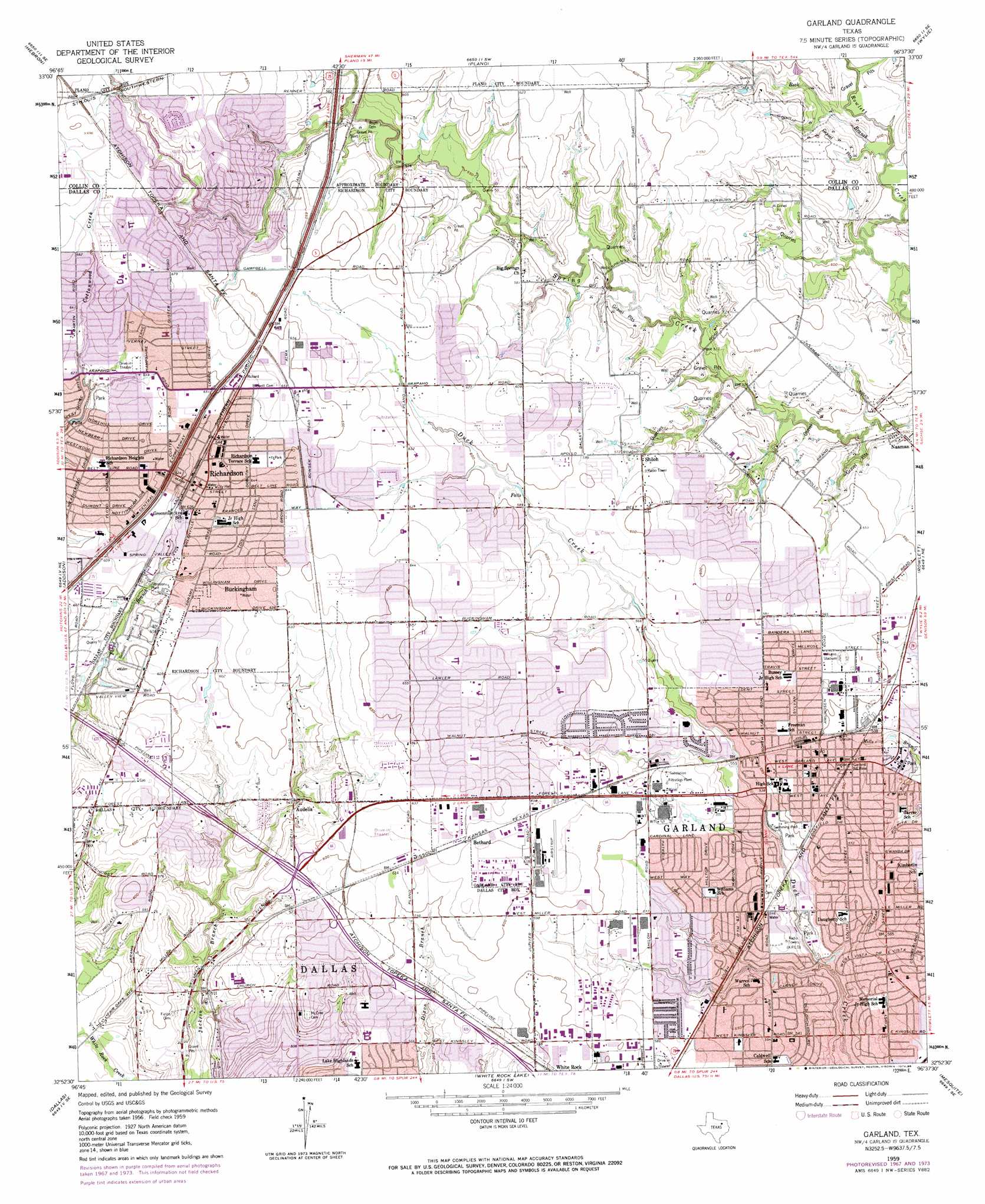
Garland Topo Map Texas
To zoom in, hover over the map of Garland
USGS Topo Quad 32096h6 - 1:24,000 scale
| Topo Map Name: | Garland |
| USGS Topo Quad ID: | 32096h6 |
| Print Size: | ca. 21 1/4" wide x 27" high |
| Southeast Coordinates: | 32.875° N latitude / 96.625° W longitude |
| Map Center Coordinates: | 32.9375° N latitude / 96.6875° W longitude |
| U.S. State: | TX |
| Filename: | o32096h6.jpg |
| Download Map JPG Image: | Garland topo map 1:24,000 scale |
| Map Type: | Topographic |
| Topo Series: | 7.5´ |
| Map Scale: | 1:24,000 |
| Source of Map Images: | United States Geological Survey (USGS) |
| Alternate Map Versions: |
Garland TX 1959, updated 1960 Download PDF Buy paper map Garland TX 1959, updated 1966 Download PDF Buy paper map Garland TX 1959, updated 1969 Download PDF Buy paper map Garland TX 1959, updated 1974 Download PDF Buy paper map Garland TX 1959, updated 1986 Download PDF Buy paper map Garland TX 2010 Download PDF Buy paper map Garland TX 2012 Download PDF Buy paper map Garland TX 2016 Download PDF Buy paper map |
1:24,000 Topo Quads surrounding Garland
Little Elm |
Frisco |
Mckinney West |
Mckinney East |
Culleoka |
Lewisville East |
Hebron |
Plano |
Wylie |
Lavon |
Carrollton |
Addison |
Garland |
Rowlett |
Rockwall |
Irving |
Dallas |
White Rock Lake |
Mesquite |
Forney North |
Duncanville |
Oak Cliff |
Hutchins |
Seagoville |
Forney South |
> Back to 32096e1 at 1:100,000 scale
> Back to 32096a1 at 1:250,000 scale
> Back to U.S. Topo Maps home
Garland topo map: Gazetteer
Garland: Airports
BMCG Heliport elevation 167m 547′City of Garland Heliport elevation 182m 597′
Garland/Dallas-Fort Worth Heloplex elevation 183m 600′
Owens Country Sausage Heliport elevation 177m 580′
Superturf Heliport elevation 173m 567′
Garland: Crossings
Interchange 15 elevation 183m 600′Interchange 16 elevation 177m 580′
Interchange 17 elevation 175m 574′
Interchange 18A elevation 184m 603′
Interchange 18B elevation 184m 603′
Garland: Parks
Alamo Park elevation 174m 570′Berkner Park elevation 191m 626′
Brackenridge Park elevation 150m 492′
Brisby Park elevation 182m 597′
Canyon Creek Park elevation 204m 669′
Central Park elevation 164m 538′
Coomer Park elevation 163m 534′
Crowley Park elevation 178m 583′
Cullam Park elevation 178m 583′
Cullom Softball Field elevation 178m 583′
Custer Park elevation 206m 675′
Dallas Activities Center - University of Texas elevation 209m 685′
Dallas Soccer Complex - University of Texas elevation 208m 682′
Foxboro Park elevation 170m 557′
Garland Christian Stadium elevation 165m 541′
Garland High Softball Field elevation 175m 574′
Greenville Avenue Stadium elevation 187m 613′
Groves Park elevation 184m 603′
Harry Moss Park elevation 146m 479′
Heights Park elevation 190m 623′
Holford Park elevation 179m 587′
Holford Softball Field elevation 178m 583′
Huffhines Park elevation 188m 616′
Kingsley Park elevation 168m 551′
Lookout Park elevation 178m 583′
Mark Twain Park elevation 189m 620′
Naaman Forest High School Softball Field elevation 158m 518′
Oden Park elevation 157m 515′
One Eleven Ranch Park elevation 147m 482′
Peavy Park elevation 179m 587′
Prairie Creek Park elevation 177m 580′
Richland Park elevation 188m 616′
Skyline Park elevation 165m 541′
Soccer Spectrum elevation 197m 646′
Spring Creek Forest Preserve elevation 153m 501′
Terrace Park elevation 199m 652′
Tinsley Park elevation 165m 541′
Watson Park elevation 193m 633′
Wildcat-Ram Stadium elevation 165m 541′
Williams Stadium elevation 174m 570′
Winters Softball Complex elevation 165m 541′
Yale Park elevation 189m 620′
Yarborough Park elevation 174m 570′
Garland: Populated Places
Audelia elevation 168m 551′Bethard elevation 189m 620′
Buckingham elevation 191m 626′
Embree (historical) elevation 166m 544′
Garland elevation 168m 551′
Naaman elevation 150m 492′
Richardson elevation 192m 629′
Shiloh elevation 171m 561′
White Rock elevation 183m 600′
Garland: Post Offices
Garland Post Office elevation 170m 557′Huffhines Park Post Office elevation 195m 639′
Kingsley Post Office elevation 169m 554′
Lake Highlands Post Office elevation 184m 603′
North Garland Post Office elevation 179m 587′
Richardson Post Office elevation 196m 643′
Richland Post Office elevation 183m 600′
Garland: Springs
Spring Creek Springs elevation 147m 482′Garland: Streams
Beck Branch elevation 151m 495′Garland: Trails
Breckenridge Park Trail elevation 165m 541′Duck Creek Trail elevation 185m 606′
Spring Creek Nature Area Trail elevation 175m 574′
Garland digital topo map on disk
Buy this Garland topo map showing relief, roads, GPS coordinates and other geographical features, as a high-resolution digital map file on DVD: