Ok Canyon Topo Map New Mexico
To zoom in, hover over the map of Ok Canyon
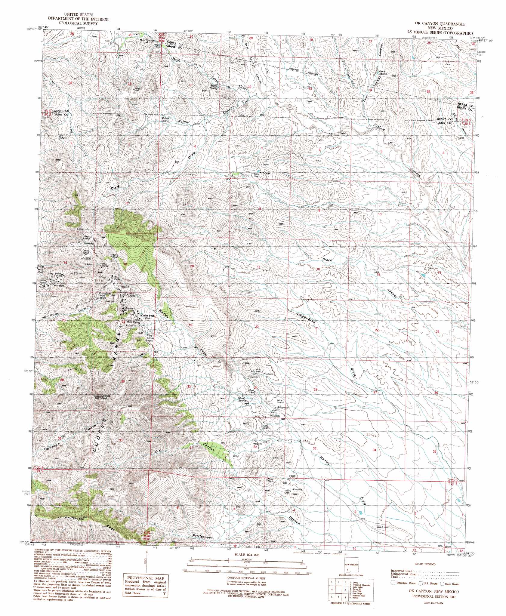
USGS Topo Quad 32107e6 - 1:24,000 scale
| Topo Map Name: | Ok Canyon |
| USGS Topo Quad ID: | 32107e6 |
| Print Size: | ca. 21 1/4" wide x 27" high |
| Southeast Coordinates: | 32.5° N latitude / 107.625° W longitude |
| Map Center Coordinates: | 32.5625° N latitude / 107.6875° W longitude |
| U.S. State: | NM |
| Filename: | o32107e6.jpg |
| Download Map JPG Image: | Ok Canyon topo map 1:24,000 scale |
| Map Type: | Topographic |
| Topo Series: | 7.5´ |
| Map Scale: | 1:24,000 |
| Source of Map Images: | United States Geological Survey (USGS) |
| Alternate Map Versions: |
Ok Canyon NM 1989, updated 1989 Download PDF Buy paper map OK Canyon NM 2010 Download PDF Buy paper map OK Canyon NM 2013 Download PDF Buy paper map OK Canyon NM 2017 Download PDF Buy paper map |
1:24,000 Topo Quads surrounding Ok Canyon
San Lorenzo |
Maverick Mountain |
Pa Mountain |
Mcclede Mountain |
Clark Spring Canyon |
Whitehorse Mountain |
Dwyer |
Whiterock Mountain |
Lake Valley |
Jug Canyon |
Taylor Mountain |
Faywood Se |
Ok Canyon |
Greg Hills |
Nutt |
Spalding |
Goat Ridge |
Massacre Peak |
Florida |
Good Sight Peak |
Williams Ranch |
Deming West |
Deming East |
Carne |
Myndus |
> Back to 32107e1 at 1:100,000 scale
> Back to 32106a1 at 1:250,000 scale
> Back to U.S. Topo Maps home
Ok Canyon topo map: Gazetteer
Ok Canyon: Mines
Gladys Mine elevation 2116m 6942′Graphic Mine elevation 1638m 5374′
Greenleaf 3 Mine elevation 2071m 6794′
Greenleaf 4 Mine elevation 2071m 6794′
Greenleaf 5 Mine elevation 2071m 6794′
Hope Mine elevation 2071m 6794′
Inez Mine elevation 2071m 6794′
Little Mary Mine elevation 2071m 6794′
Lookout Deposit elevation 2177m 7142′
Mickey Mine elevation 2071m 6794′
Old Commodore Mine elevation 2071m 6794′
Poe Group Mine elevation 2071m 6794′
Raithel Mine elevation 2071m 6794′
Silver Cave Number 2 elevation 2000m 6561′
Summit Group Mine elevation 2071m 6794′
Surprise and Mahonney Number 1 Shaft elevation 1986m 6515′
Webster Mine elevation 1986m 6515′
West Side Mine elevation 2071m 6794′
White Oaks Mine elevation 2071m 6794′
Ok Canyon: Parks
Cookes Range Wilderness Study Area elevation 2444m 8018′Ok Canyon: Ranges
Cookes Range elevation 2293m 7522′Ok Canyon: Springs
Burro Spring elevation 1691m 5547′Dove Spring elevation 1646m 5400′
Mule Springs elevation 1726m 5662′
Riley Spring elevation 1877m 6158′
Shale Spring elevation 1658m 5439′
Walnut Spring elevation 1740m 5708′
Ok Canyon: Summits
Cookes Peak elevation 2444m 8018′Ok Canyon: Valleys
Bear Springs Canyon elevation 1659m 5442′Clark Draw elevation 1707m 5600′
Dove Springs Canyon elevation 1609m 5278′
Ok Canyon elevation 1594m 5229′
Walnut Canyon elevation 1670m 5479′
Ok Canyon: Wells
01507 Water Well elevation 1711m 5613′01508 Water Well elevation 1705m 5593′
01509 Water Well elevation 1610m 5282′
01510 Water Well elevation 1705m 5593′
01511 Water Well elevation 1721m 5646′
01512 Water Well elevation 1845m 6053′
01514 Water Well elevation 1598m 5242′
01522 Water Well elevation 1843m 6046′
Ok Canyon digital topo map on disk
Buy this Ok Canyon topo map showing relief, roads, GPS coordinates and other geographical features, as a high-resolution digital map file on DVD: