Ninetysix Hills Sw Topo Map Arizona
To zoom in, hover over the map of Ninetysix Hills Sw
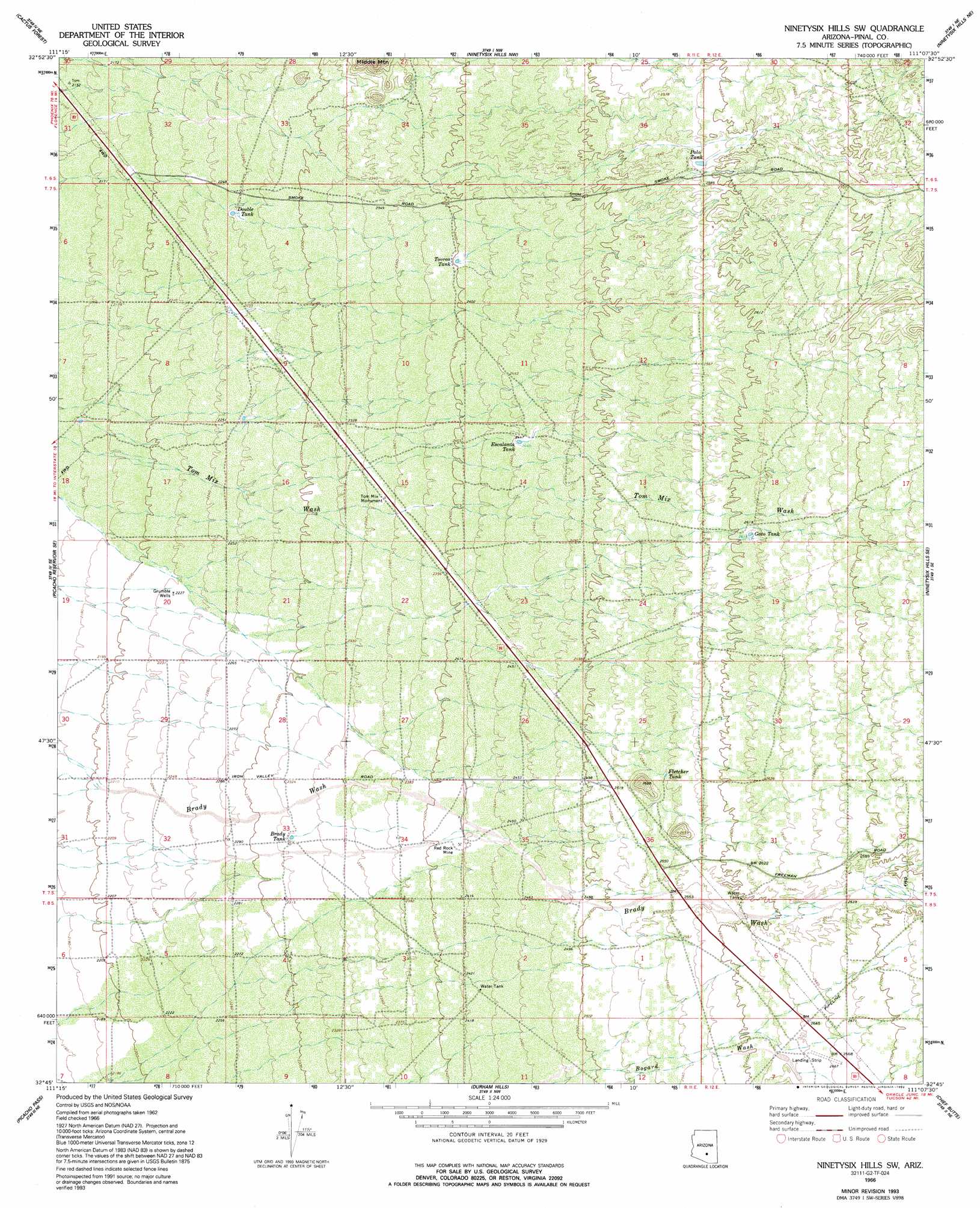
USGS Topo Quad 32111g2 - 1:24,000 scale
| Topo Map Name: | Ninetysix Hills Sw |
| USGS Topo Quad ID: | 32111g2 |
| Print Size: | ca. 21 1/4" wide x 27" high |
| Southeast Coordinates: | 32.75° N latitude / 111.125° W longitude |
| Map Center Coordinates: | 32.8125° N latitude / 111.1875° W longitude |
| U.S. State: | AZ |
| Filename: | o32111g2.jpg |
| Download Map JPG Image: | Ninetysix Hills Sw topo map 1:24,000 scale |
| Map Type: | Topographic |
| Topo Series: | 7.5´ |
| Map Scale: | 1:24,000 |
| Source of Map Images: | United States Geological Survey (USGS) |
| Alternate Map Versions: |
Ninetysix Hills SW AZ 1966, updated 1969 Download PDF Buy paper map Ninetysix Hills SW AZ 1966, updated 1985 Download PDF Buy paper map Ninetysix Hills SW AZ 1966, updated 1992 Download PDF Buy paper map Ninetysix Hills SW AZ 1966, updated 1993 Download PDF Buy paper map Ninetysix Hills SW AZ 2011 Download PDF Buy paper map Ninetysix Hills SW AZ 2014 Download PDF Buy paper map |
1:24,000 Topo Quads surrounding Ninetysix Hills Sw
Florence |
Florence Se |
North Butte |
Grayback |
Kearny |
Valley Farms |
Cactus Forest |
Ninetysix Hills Nw |
Ninetysix Hills Ne |
Crozier Peak |
Picacho Reservoir |
Picacho Reservoir Se |
Ninetysix Hills Sw |
Ninetysix Hills Se |
Black Mountain |
Newman Peak |
Picacho Pass |
Durham Hills |
Chief Butte |
Fortified Peak |
Samaniego Hills |
Red Rock |
Desert Peak |
Tortolita Mountains |
Oracle Junction |
> Back to 32111e1 at 1:100,000 scale
> Back to 32110a1 at 1:250,000 scale
> Back to U.S. Topo Maps home
Ninetysix Hills Sw topo map: Gazetteer
Ninetysix Hills Sw: Mines
Red Rock Mine elevation 737m 2417′Ninetysix Hills Sw: Parks
Tom Mix Monument elevation 718m 2355′Ninetysix Hills Sw: Reservoirs
Brady Tank elevation 710m 2329′Double Tank elevation 691m 2267′
Escalanta Tank elevation 745m 2444′
Fletcher Tank elevation 780m 2559′
Gato Tank elevation 796m 2611′
Polo Tank elevation 785m 2575′
Tovrea Tank elevation 733m 2404′
Ninetysix Hills Sw: Wells
Grumble Wells elevation 678m 2224′Ninetysix Hills Sw digital topo map on disk
Buy this Ninetysix Hills Sw topo map showing relief, roads, GPS coordinates and other geographical features, as a high-resolution digital map file on DVD: