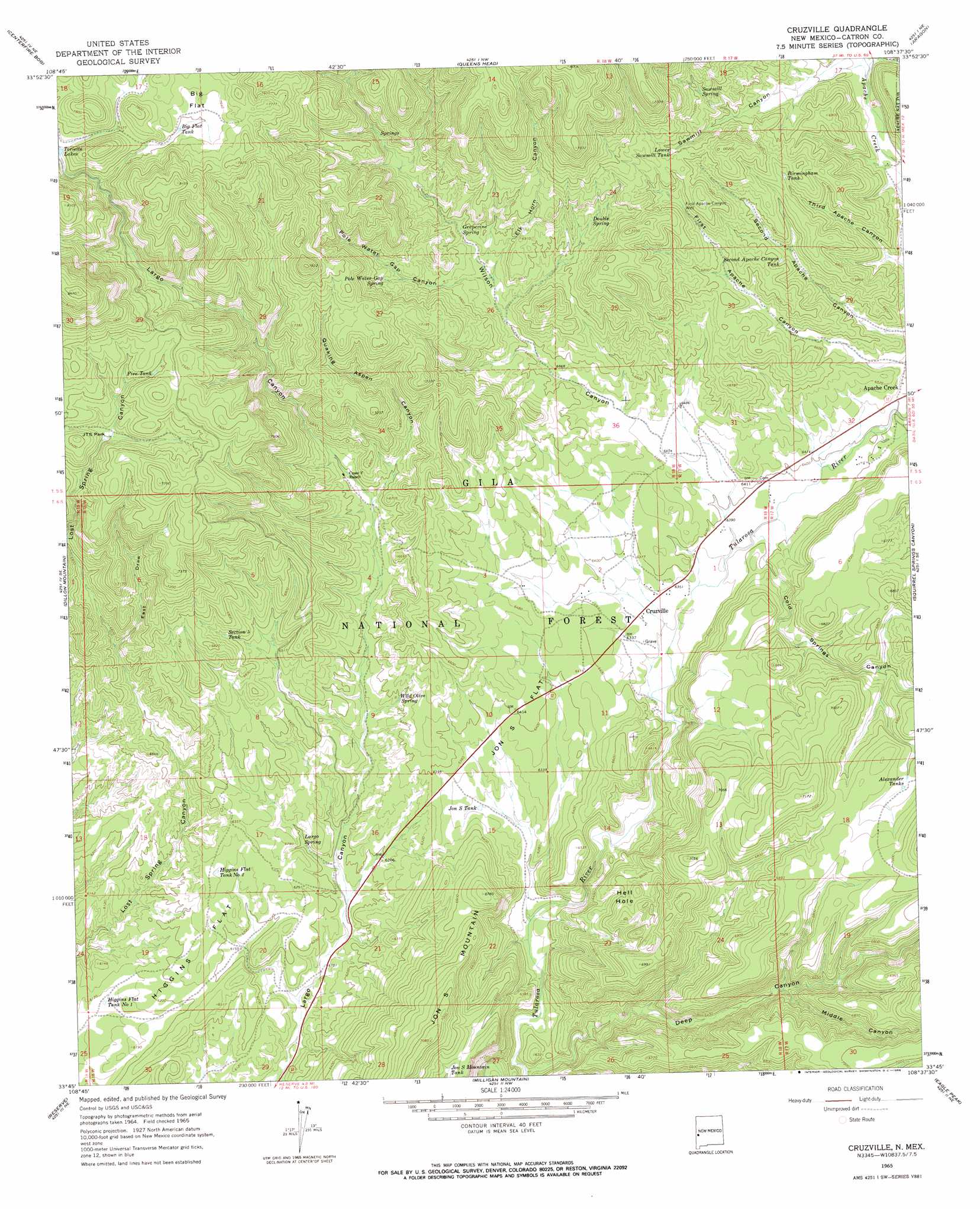
Cruzville Topo Map New Mexico
To zoom in, hover over the map of Cruzville
USGS Topo Quad 33108g6 - 1:24,000 scale
| Topo Map Name: | Cruzville |
| USGS Topo Quad ID: | 33108g6 |
| Print Size: | ca. 21 1/4" wide x 27" high |
| Southeast Coordinates: | 33.75° N latitude / 108.625° W longitude |
| Map Center Coordinates: | 33.8125° N latitude / 108.6875° W longitude |
| U.S. State: | NM |
| Filename: | o33108g6.jpg |
| Download Map JPG Image: | Cruzville topo map 1:24,000 scale |
| Map Type: | Topographic |
| Topo Series: | 7.5´ |
| Map Scale: | 1:24,000 |
| Source of Map Images: | United States Geological Survey (USGS) |
| Alternate Map Versions: |
Cruzville NM 1965, updated 1968 Download PDF Buy paper map Cruzville NM 1999, updated 2002 Download PDF Buy paper map Cruzville NM 2011 Download PDF Buy paper map Cruzville NM 2013 Download PDF Buy paper map Cruzville NM 2017 Download PDF Buy paper map |
| FStopo: | US Forest Service topo Cruzville is available: Download FStopo PDF Download FStopo TIF |
1:24,000 Topo Quads surrounding Cruzville
Jones Canyon |
Black Peak |
Gallo Mountains West |
Gallo Mountains East |
Slaughter Mesa |
Underwood Lake |
Centerfire Bog |
Queens Head |
Aragon |
Tullarosa Canyon |
Luna |
Dillon Mountain |
Cruzville |
Squirrel Springs Canyon |
John Kerr Peak |
Bull Basin |
Reserve |
Milligan Mountain |
Eagle Peak |
Collins Park |
Saliz Pass |
O Block Canyon |
Sign Camp Mountain |
Telephone Canyon |
Pitchfork Canyon |
> Back to 33108e1 at 1:100,000 scale
> Back to 33108a1 at 1:250,000 scale
> Back to U.S. Topo Maps home
Cruzville topo map: Gazetteer
Cruzville: Areas
Hell Hole elevation 2015m 6610′Cruzville: Flats
Big Flat elevation 2329m 7641′Higgins Flat elevation 1916m 6286′
Jon S Flat elevation 1956m 6417′
JTS Park elevation 2198m 7211′
Cruzville: Populated Places
Apache Creek elevation 1954m 6410′Cruzville elevation 1932m 6338′
Cruzville: Post Offices
Apache Creek Post Office (historical) elevation 1954m 6410′Cruzville: Reservoirs
Alexander Tanks elevation 2077m 6814′Big Canyon Tank elevation 2003m 6571′
Big Flat Tank elevation 2316m 7598′
Birmingham Tank elevation 2083m 6833′
East Draw Tank elevation 2228m 7309′
Fire Tank elevation 2253m 7391′
Higgins Flat Tank Number 1 elevation 1862m 6108′
Higgins Flat Tank Number 2 elevation 1914m 6279′
Jon S Mountain Tank elevation 2019m 6624′
Jon S Tank elevation 1912m 6272′
Lower Sawmill Tank elevation 2129m 6984′
Mountain Lion Tank elevation 1932m 6338′
Needlepark Tank elevation 2213m 7260′
Rockheader Tank elevation 1915m 6282′
Second Apache Canyon Tank elevation 2066m 6778′
Section Five Tank elevation 2023m 6637′
Wheeler Tank elevation 1998m 6555′
Cruzville: Springs
Cross Spring elevation 2035m 6676′Double Spring elevation 2095m 6873′
Grapevine Spring elevation 2058m 6751′
Grapevine Spring elevation 2056m 6745′
Largo Spring elevation 1888m 6194′
McMahon Spring elevation 2135m 7004′
Outlaw Spring elevation 2062m 6765′
Pole Water Gap Spring elevation 2099m 6886′
Sawmill Spring elevation 2118m 6948′
West Largo Spring elevation 1890m 6200′
Wild Olive Spring elevation 1946m 6384′
Cruzville: Streams
Apache Creek elevation 1952m 6404′East Draw elevation 2022m 6633′
Cruzville: Summits
Jon S Mountain elevation 2154m 7066′Cruzville: Valleys
Big Canyon elevation 1908m 6259′Cold Springs Canyon elevation 1939m 6361′
Deep Canyon elevation 1850m 6069′
Elk Horn Canyon elevation 2032m 6666′
Middle Canyon elevation 1962m 6437′
Pole Water Gap Canyon elevation 2032m 6666′
Quaking Aspen Canyon elevation 1994m 6541′
Red Steer Canyon elevation 1993m 6538′
Squirrel Springs Canyon elevation 1951m 6400′
Wilson Canyon elevation 1964m 6443′
Cruzville: Wells
First Apache Canyon Well elevation 2105m 6906′GSF-2336 Water Well elevation 1957m 6420′
Sawmill Well elevation 1882m 6174′
Cruzville digital topo map on disk
Buy this Cruzville topo map showing relief, roads, GPS coordinates and other geographical features, as a high-resolution digital map file on DVD: