Palm Springs Topo Map California
To zoom in, hover over the map of Palm Springs
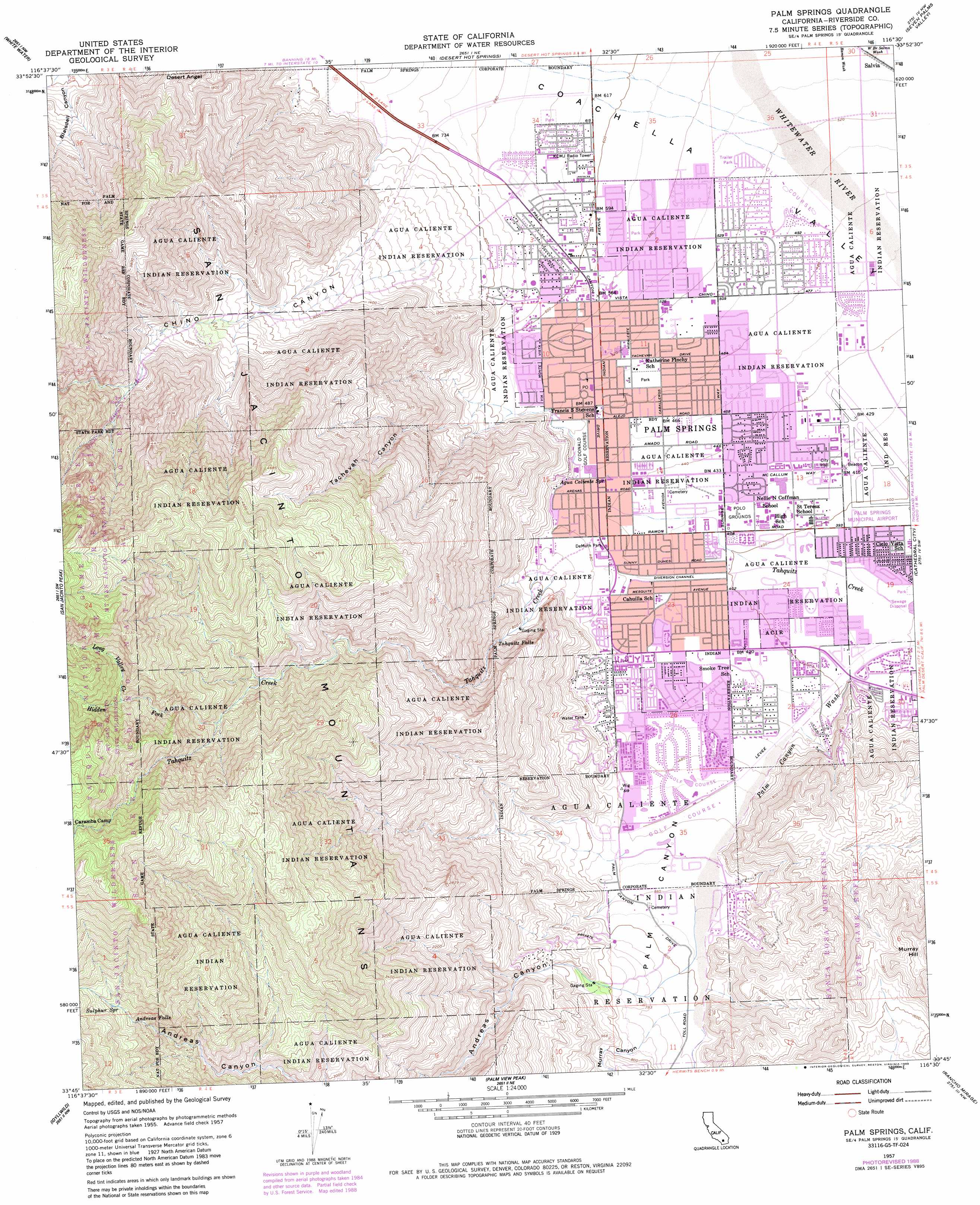
USGS Topo Quad 33116g5 - 1:24,000 scale
| Topo Map Name: | Palm Springs |
| USGS Topo Quad ID: | 33116g5 |
| Print Size: | ca. 21 1/4" wide x 27" high |
| Southeast Coordinates: | 33.75° N latitude / 116.5° W longitude |
| Map Center Coordinates: | 33.8125° N latitude / 116.5625° W longitude |
| U.S. State: | CA |
| Filename: | o33116g5.jpg |
| Download Map JPG Image: | Palm Springs topo map 1:24,000 scale |
| Map Type: | Topographic |
| Topo Series: | 7.5´ |
| Map Scale: | 1:24,000 |
| Source of Map Images: | United States Geological Survey (USGS) |
| Alternate Map Versions: |
Palm Springs CA 1957, updated 1959 Download PDF Buy paper map Palm Springs CA 1957, updated 1963 Download PDF Buy paper map Palm Springs CA 1957, updated 1973 Download PDF Buy paper map Palm Springs CA 1957, updated 1980 Download PDF Buy paper map Palm Springs CA 1957, updated 1984 Download PDF Buy paper map Palm Springs CA 1957, updated 1988 Download PDF Buy paper map Palm Springs CA 1975, updated 1977 Download PDF Buy paper map Palm Springs CA 1996, updated 1999 Download PDF Buy paper map Palm Springs CA 2012 Download PDF Buy paper map Palm Springs CA 2015 Download PDF Buy paper map |
| FStopo: | US Forest Service topo Palm Springs is available: Download FStopo PDF Download FStopo TIF |
1:24,000 Topo Quads surrounding Palm Springs
San Gorgonio Mountain |
Catclaw Flat |
Morongo Valley |
Yucca Valley South |
Joshua Tree South |
Cabazon |
White Water |
Desert Hot Springs |
Seven Palms Valley |
East Deception Canyon |
Lake Fulmor |
San Jacinto Peak |
Palm Springs |
Cathedral City |
Myoma |
Blackburn Canyon |
Idyllwild |
Palm View Peak |
Rancho Mirage |
La Quinta |
Cahuilla Mountain |
Anza |
Butterfly Peak |
Toro Peak |
Martinez Mountain |
> Back to 33116e1 at 1:100,000 scale
> Back to 33116a1 at 1:250,000 scale
> Back to U.S. Topo Maps home
Palm Springs topo map: Gazetteer
Palm Springs: Airports
Palm Springs Municipal Airport elevation 129m 423′Palm Springs: Canals
Baristo Flood Control Channel elevation 130m 426′Tahquitz Creek Channel elevation 129m 423′
Palm Springs: Dams
Tachevah Creek Detention Dam elevation 132m 433′Palm Springs: Falls
Andreas Falls elevation 1407m 4616′Tahquitz Falls elevation 254m 833′
Palm Springs: Parks
Angels Stadium elevation 127m 416′Baristo Park elevation 134m 439′
Demuth Park elevation 113m 370′
Desert Highland Park elevation 196m 643′
Ruth Hardy Park elevation 150m 492′
Sunrise Plaza elevation 127m 416′
Victoria Park elevation 174m 570′
Palm Springs: Populated Places
Palm Springs elevation 146m 479′Salvia elevation 168m 551′
Palm Springs: Post Offices
Palm Springs Post Office (historical) elevation 146m 479′Palm Springs: Springs
Agua Caliente Spring elevation 139m 456′Sulphur Spring elevation 1494m 4901′
Palm Springs: Streams
Hidden Fork elevation 1119m 3671′Long Valley Creek elevation 1470m 4822′
Ramon Wash elevation 166m 544′
West Branch Salvia Wash elevation 169m 554′
Palm Springs: Valleys
Andreas Canyon elevation 183m 600′Chino Canyon elevation 233m 764′
Murray Canyon elevation 205m 672′
Palm Canyon elevation 121m 396′
Tachevah Canyon elevation 178m 583′
Palm Springs digital topo map on disk
Buy this Palm Springs topo map showing relief, roads, GPS coordinates and other geographical features, as a high-resolution digital map file on DVD: