Meridianville Topo Map Alabama
To zoom in, hover over the map of Meridianville
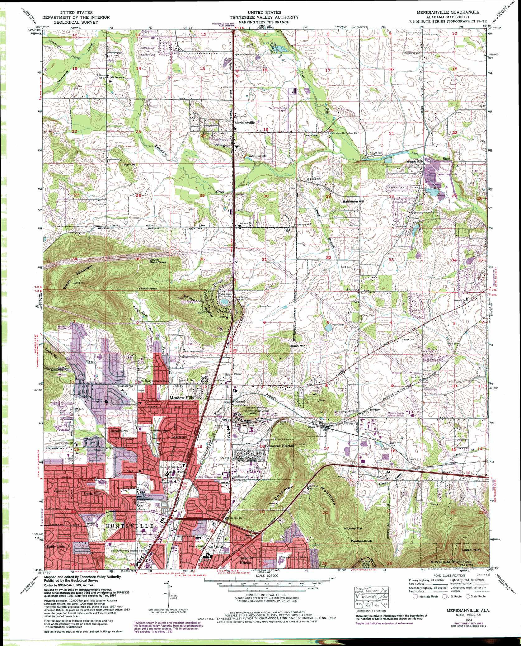
USGS Topo Quad 34086g5 - 1:24,000 scale
| Topo Map Name: | Meridianville |
| USGS Topo Quad ID: | 34086g5 |
| Print Size: | ca. 21 1/4" wide x 27" high |
| Southeast Coordinates: | 34.75° N latitude / 86.5° W longitude |
| Map Center Coordinates: | 34.8125° N latitude / 86.5625° W longitude |
| U.S. State: | AL |
| Filename: | o34086g5.jpg |
| Download Map JPG Image: | Meridianville topo map 1:24,000 scale |
| Map Type: | Topographic |
| Topo Series: | 7.5´ |
| Map Scale: | 1:24,000 |
| Source of Map Images: | United States Geological Survey (USGS) |
| Alternate Map Versions: |
Meridianville AL 1936 Download PDF Buy paper map Meridianville AL 1948, updated 1964 Download PDF Buy paper map Meridianville AL 1951, updated 1951 Download PDF Buy paper map Meridianville AL 1964, updated 1968 Download PDF Buy paper map Meridianville AL 1964, updated 1976 Download PDF Buy paper map Meridianville AL 1964, updated 1982 Download PDF Buy paper map Meridianville AL 2011 Download PDF Buy paper map Meridianville AL 2014 Download PDF Buy paper map |
1:24,000 Topo Quads surrounding Meridianville
Dellrose |
Taft |
Lincoln |
Flintville |
Huntland |
Ardmore |
Toney |
Fisk |
New Market |
King Cove |
Capshaw |
Jeff |
Meridianville |
Maysville |
Hollytree |
Greenbrier |
Madison |
Huntsville |
Moontown |
Paint Rock |
Mason Ridge |
Triana |
Farley |
New Hope |
Grant |
> Back to 34086e1 at 1:100,000 scale
> Back to 34086a1 at 1:250,000 scale
> Back to U.S. Topo Maps home
Meridianville topo map: Gazetteer
Meridianville: Airports
Huntsville Airport North elevation 227m 744′Meridianville: Gaps
Certain Gap elevation 295m 967′Hickory Flat elevation 323m 1059′
Meridianville: Lakes
Mason Lake (historical) elevation 206m 675′Meridianville: Parks
Chapman Park elevation 206m 675′John H Steigerwood Field elevation 207m 679′
Ka-Lea Park elevation 212m 695′
Lakewood Park elevation 202m 662′
Maplewood Park elevation 234m 767′
Oakmont Park elevation 207m 679′
Windsor Manor Park elevation 224m 734′
Meridianville: Populated Places
Ashland elevation 233m 764′Baltimore Hill elevation 250m 820′
Bellemeade elevation 219m 718′
Blue Spring Garden elevation 228m 748′
Brookhurst elevation 219m 718′
Cedar Valley elevation 243m 797′
Cedargate elevation 234m 767′
Chapman Heights elevation 214m 702′
Chase elevation 242m 793′
Cherokee Hills elevation 233m 764′
Cherry Creek elevation 227m 744′
Colonial Gardens elevation 236m 774′
Colonial Hills elevation 211m 692′
Country Club Estates elevation 217m 711′
Country Village elevation 227m 744′
Davis Hills elevation 229m 751′
Davis Hills Estates elevation 219m 718′
Eastridge elevation 223m 731′
Edgemont elevation 211m 692′
Edmonton Heights elevation 228m 748′
Glen Park elevation 207m 679′
Greenhill elevation 215m 705′
Grove View Acres elevation 231m 757′
Kildere Estates elevation 201m 659′
Lakewood elevation 223m 731′
Lakewood Manor elevation 217m 711′
Lincoya elevation 225m 738′
Meadow Hills elevation 253m 830′
Meadow Lane Estates elevation 217m 711′
Mercury elevation 233m 764′
Meridianville elevation 241m 790′
Moores Mill elevation 210m 688′
Mount Charron Estates elevation 292m 958′
Mount Lebanon elevation 237m 777′
Mountain Springs Estates elevation 229m 751′
Normal elevation 220m 721′
Pearsall Gardens elevation 198m 649′
Pleasant Acres elevation 235m 770′
Scenic View elevation 218m 715′
Shady Lane elevation 212m 695′
Stag Run elevation 235m 770′
The Woodlands elevation 226m 741′
Valley Park elevation 233m 764′
Valley View Estates elevation 274m 898′
Windsor Manor elevation 216m 708′
Meridianville: Post Offices
Blue Spring Post Office elevation 206m 675′Chase Post Office elevation 241m 790′
Meridianville Post Office elevation 234m 767′
Meridianville: Reservoirs
Ware Pond elevation 228m 748′Meridianville: Springs
Blue Spring elevation 209m 685′Blue Spring elevation 210m 688′
Harris Spring elevation 213m 698′
Moore Quarter Spring elevation 241m 790′
Smithers Spring elevation 247m 810′
Meridianville: Streams
Banyon Creek elevation 230m 754′Beaverdam Creek elevation 211m 692′
East Fork Pinhook Creek elevation 207m 679′
Normal Branch elevation 192m 629′
Sweetwater Branch elevation 230m 754′
West Fork Pinhook Creek elevation 207m 679′
Meridianville: Summits
Brush Mountain elevation 285m 935′Chapman Mountain elevation 370m 1213′
Devils Race Track elevation 317m 1040′
Logan Point elevation 481m 1578′
Panther Knob elevation 347m 1138′
Smithers Mountain elevation 347m 1138′
Wade Mountain elevation 455m 1492′
Meridianville: Valleys
Jude Hollow elevation 221m 725′Meridianville digital topo map on disk
Buy this Meridianville topo map showing relief, roads, GPS coordinates and other geographical features, as a high-resolution digital map file on DVD: