Huntsville Topo Map Alabama
To zoom in, hover over the map of Huntsville
USGS Topo Map 34086e1 - 1:100,000 scale
| Topo Map Name: | Huntsville |
| USGS Topo Quad ID: | 34086e1 |
| Print Size: | ca. 39" wide x 24" high |
| Southeast Coordinates: | 34.5° N latitude / 86° W longitude |
| Map Center Coordinates: | 34.75° N latitude / 86.5° W longitude |
| U.S. States: | AL, TN |
| Filename: | 34086e1.jpg |
| Download Map JPG Image: | Huntsville topo map 1:100,000 scale |
| Map Type: | Topographic |
| Topo Series: | 30´x60´ |
| Map Scale: | 1:100,000 |
| Source of Map Images: | United States Geological Survey (USGS) |
| Alternate Map Versions: |
Huntsville AL 1984, updated 1986 Download PDF Buy paper map Huntsville AL 1984, updated 1988 Download PDF Buy paper map Huntsville AL 1984, updated 1988 Download PDF Buy paper map |
1:100,000 Topos surrounding Huntsville
Lawrenceburg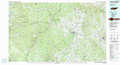 |
Tullahoma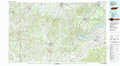 |
Chattanooga |
Tuscumbia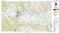 |
Huntsville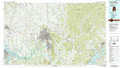 |
Chickamauga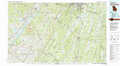 |
Haleyville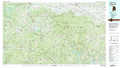 |
Guntersville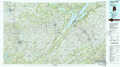 |
Rome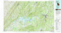 |
> Back to 34086a1 at 1:250,000 scale
> Back to U.S. Topo Maps home
1:24,000 Topo Quads covered by the spatial extent of this 100k map (Huntsville)
|
Elkmont 
|
Ardmore 
|
Toney 
|
Fisk 
|
New Market 
|
King Cove 
|
Estill Fork 
|
Hytop 
|
|
Athens 
|
Capshaw 
|
Jeff 
|
Meridianville 
|
Maysville 
|
Hollytree 
|
Princeton 
|
Mud Creek 
|
|
Tanner 
|
Greenbrier 
|
Madison 
|
Huntsville 
|
Moontown 
|
Paint Rock 
|
Lim Rock 
|
Scottsboro 
|
|
Decatur 
|
Mason Ridge 
|
Triana 
|
Farley 
|
New Hope 
|
Grant 
|
Swearengin 
|
Langston 
|
