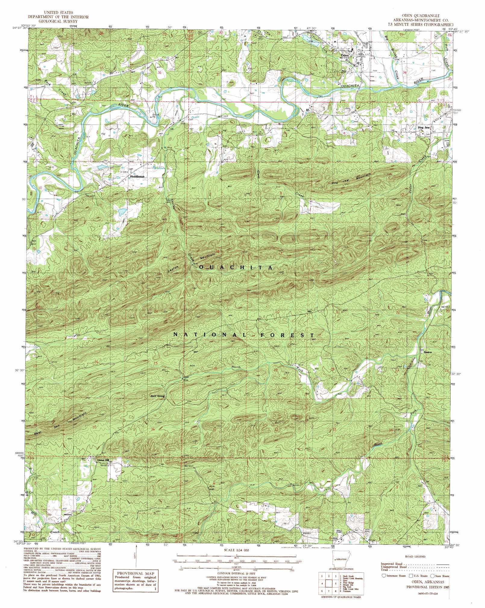
Oden Topo Map Arkansas
To zoom in, hover over the map of Oden
USGS Topo Quad 34093e7 - 1:24,000 scale
| Topo Map Name: | Oden |
| USGS Topo Quad ID: | 34093e7 |
| Print Size: | ca. 21 1/4" wide x 27" high |
| Southeast Coordinates: | 34.5° N latitude / 93.75° W longitude |
| Map Center Coordinates: | 34.5625° N latitude / 93.8125° W longitude |
| U.S. State: | AR |
| Filename: | o34093e7.jpg |
| Download Map JPG Image: | Oden topo map 1:24,000 scale |
| Map Type: | Topographic |
| Topo Series: | 7.5´ |
| Map Scale: | 1:24,000 |
| Source of Map Images: | United States Geological Survey (USGS) |
| Alternate Map Versions: |
Oden AR 1985, updated 1986 Download PDF Buy paper map Oden AR 2011 Download PDF Buy paper map Oden AR 2014 Download PDF Buy paper map |
| FStopo: | US Forest Service topo Oden is available: Download FStopo PDF Download FStopo TIF |
1:24,000 Topo Quads surrounding Oden
Boles |
Parks |
Harvey |
Little Texas |
Chula Mountain |
Y City |
Buck Knob |
Bushy Creek Mountain |
Sims |
Story |
Board Camp |
Pine Ridge |
Oden |
Mount Ida |
Reed Mountain |
Nichols Nountain |
Big Fork |
Polk Creek Mountain |
Norman |
Caddo Gap |
Umpire |
Athens |
Langley |
Lodi |
Glenwood |
> Back to 34093e1 at 1:100,000 scale
> Back to 34092a1 at 1:250,000 scale
> Back to U.S. Topo Maps home
Oden topo map: Gazetteer
Oden: Dams
Arkansas Noname 186 Dam elevation 241m 790′Oden: Populated Places
Gaston elevation 229m 751′Hog Jaw elevation 241m 790′
Huddleston elevation 264m 866′
Oden elevation 233m 764′
Redbird (historical) elevation 270m 885′
Union Hill elevation 299m 980′
Oden: Post Offices
Oden Post Office elevation 233m 764′Oden: Reservoirs
North Fork Lake elevation 283m 928′Oden: Ridges
Gaston Mountain elevation 347m 1138′Oden: Springs
Rock Spring elevation 279m 915′Oden: Streams
Big Brushy Creek elevation 460m 1509′Clear Creek elevation 221m 725′
Dry Fork elevation 285m 935′
Lick Branch elevation 216m 708′
North Fork South Fork Ouachita River elevation 219m 718′
Polk Creek elevation 214m 702′
Rock Creek elevation 228m 748′
Shirley Creek elevation 223m 731′
Oden: Summits
Bear Den Mountain elevation 460m 1509′Hog Jaw Mountain elevation 379m 1243′
Oden digital topo map on disk
Buy this Oden topo map showing relief, roads, GPS coordinates and other geographical features, as a high-resolution digital map file on DVD: