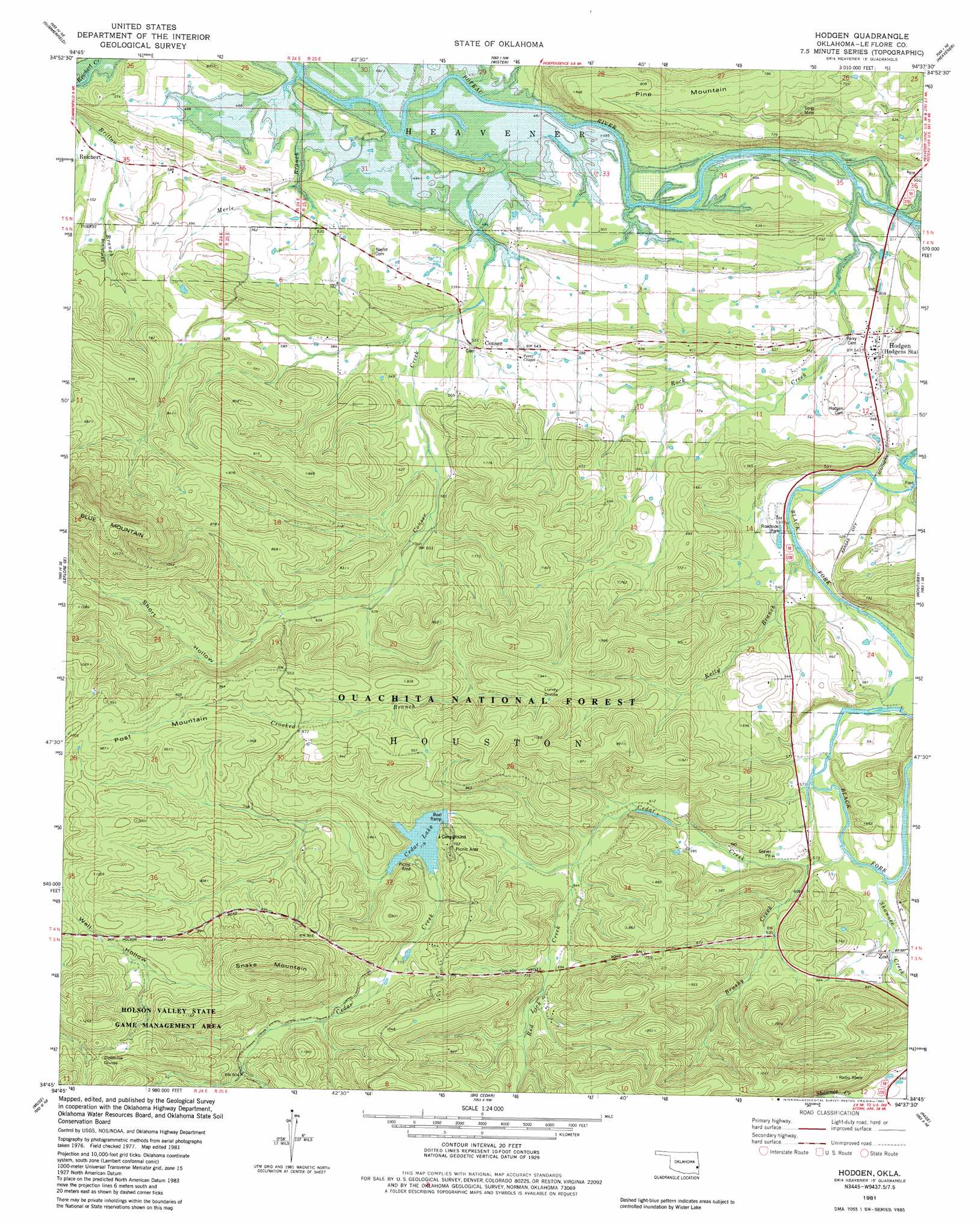
Hodgens Topo Map Oklahoma
To zoom in, hover over the map of Hodgens
USGS Topo Quad 34094g6 - 1:24,000 scale
| Topo Map Name: | Hodgens |
| USGS Topo Quad ID: | 34094g6 |
| Print Size: | ca. 21 1/4" wide x 27" high |
| Southeast Coordinates: | 34.75° N latitude / 94.625° W longitude |
| Map Center Coordinates: | 34.8125° N latitude / 94.6875° W longitude |
| U.S. State: | OK |
| Filename: | o34094g6.jpg |
| Download Map JPG Image: | Hodgens topo map 1:24,000 scale |
| Map Type: | Topographic |
| Topo Series: | 7.5´ |
| Map Scale: | 1:24,000 |
| Source of Map Images: | United States Geological Survey (USGS) |
| Alternate Map Versions: |
Hodgen OK 1981, updated 1982 Download PDF Buy paper map Hodgen OK 2011 Download PDF Buy paper map Hodgen OK 2013 Download PDF Buy paper map Hodgen OK 2016 Download PDF Buy paper map |
| FStopo: | US Forest Service topo Hodgen is available: Download FStopo PDF Download FStopo TIF |
1:24,000 Topo Quads surrounding Hodgens
Mccurtain Sw |
Potato Peaks |
Poteau West |
Poteau East |
Hartford |
Leflore |
Summerfield |
Wister |
Heavener |
Bates |
Blackjack Ridge |
Leflore Se |
Hodgens |
Hontubby |
Loving |
Whitesboro |
Muse |
Big Cedar |
Page |
Mountain Fork |
Honobia |
Ludlow |
Octavia |
Lynn Mountain |
Zafra |
> Back to 34094e1 at 1:100,000 scale
> Back to 34094a1 at 1:250,000 scale
> Back to U.S. Topo Maps home
Hodgens topo map: Gazetteer
Hodgens: Beaches
Cedar Lake North Shore elevation 238m 780′Cedar Lake South Shore elevation 238m 780′
Hodgens: Dams
Cedar Lake Dam elevation 219m 718′Cedar Lake Dam elevation 245m 803′
Hodgens: Gaps
Goldville Divide elevation 344m 1128′Lundy Divide elevation 274m 898′
Hodgens: Parks
Cedar Lake Recreation Site elevation 238m 780′Holson Valley State Game Management Area elevation 337m 1105′
Hodgens: Populated Places
Conser elevation 170m 557′Hodgen elevation 165m 541′
Hodgens Station elevation 156m 511′
Reichert elevation 163m 534′
Zoe elevation 182m 597′
Hodgens: Reservoirs
Cedar Lake elevation 245m 803′Cedar Lake elevation 219m 718′
Hodgens: Streams
Brushy Creek elevation 182m 597′Conser Creek elevation 144m 472′
Crooked Branch elevation 190m 623′
Kelly Branch elevation 158m 518′
Merle Branch elevation 148m 485′
Red Lick Creek elevation 193m 633′
Rock Creek elevation 151m 495′
Shawnee Creek elevation 166m 544′
Hodgens: Summits
Pine Mountain elevation 257m 843′Post Mountain elevation 294m 964′
Snake Mountain elevation 404m 1325′
Hodgens: Valleys
Short Hollow elevation 262m 859′Hodgens digital topo map on disk
Buy this Hodgens topo map showing relief, roads, GPS coordinates and other geographical features, as a high-resolution digital map file on DVD: