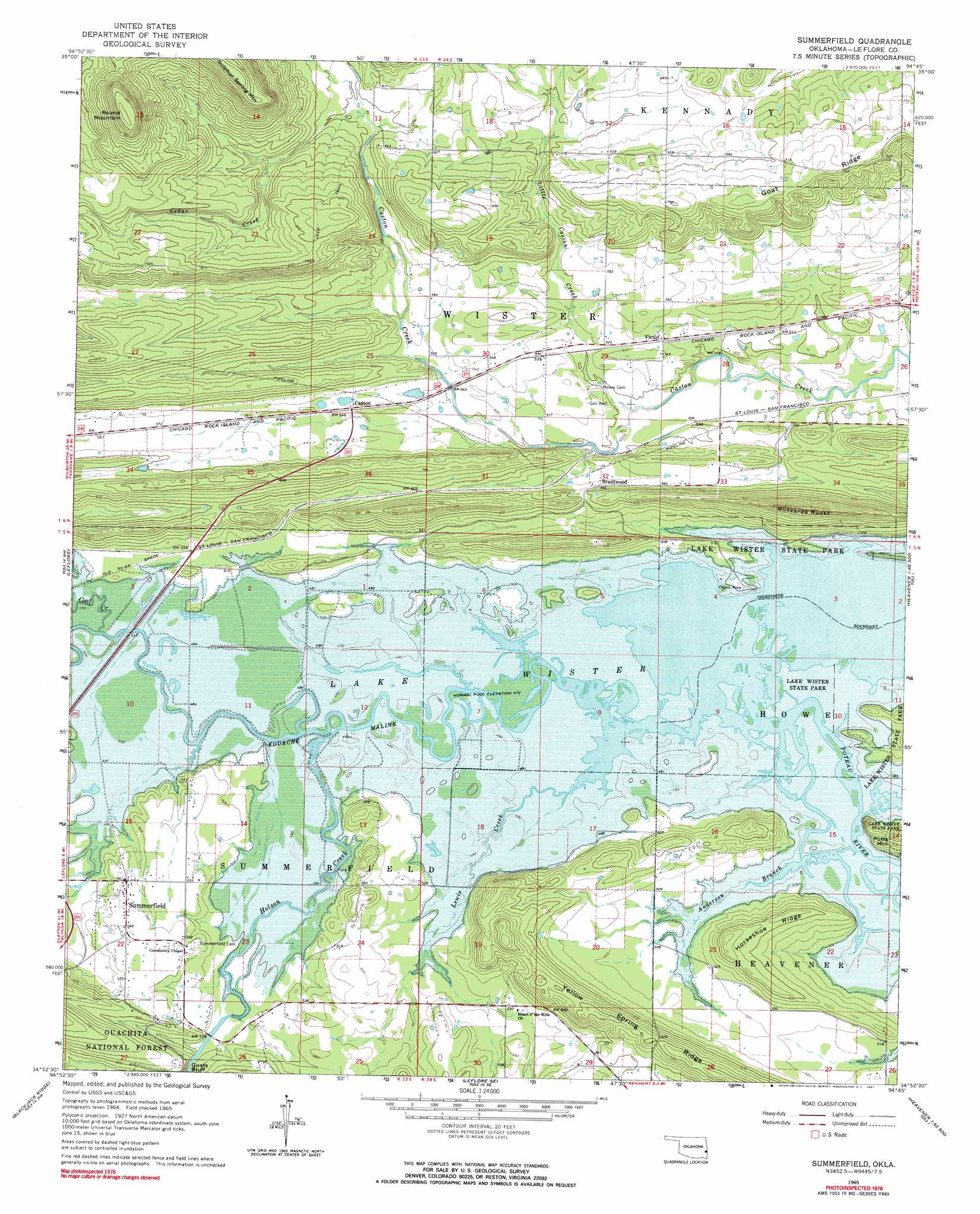
Summerfield Topo Map Oklahoma
To zoom in, hover over the map of Summerfield
USGS Topo Quad 34094h7 - 1:24,000 scale
| Topo Map Name: | Summerfield |
| USGS Topo Quad ID: | 34094h7 |
| Print Size: | ca. 21 1/4" wide x 27" high |
| Southeast Coordinates: | 34.875° N latitude / 94.75° W longitude |
| Map Center Coordinates: | 34.9375° N latitude / 94.8125° W longitude |
| U.S. State: | OK |
| Filename: | o34094h7.jpg |
| Download Map JPG Image: | Summerfield topo map 1:24,000 scale |
| Map Type: | Topographic |
| Topo Series: | 7.5´ |
| Map Scale: | 1:24,000 |
| Source of Map Images: | United States Geological Survey (USGS) |
| Alternate Map Versions: |
Summerfield OK 1965, updated 1967 Download PDF Buy paper map Summerfield OK 2011 Download PDF Buy paper map Summerfield OK 2013 Download PDF Buy paper map Summerfield OK 2016 Download PDF Buy paper map |
| FStopo: | US Forest Service topo Summerfield is available: Download FStopo PDF Download FStopo TIF |
1:24,000 Topo Quads surrounding Summerfield
Lafayette |
Mccurtain |
Bokoshe |
Panama |
Spiro |
Lequire |
Mccurtain Sw |
Potato Peaks |
Poteau West |
Poteau East |
Red Oak |
Leflore |
Summerfield |
Wister |
Heavener |
Talihina |
Blackjack Ridge |
Leflore Se |
Hodgens |
Hontubby |
Albion |
Whitesboro |
Muse |
Big Cedar |
Page |
> Back to 34094e1 at 1:100,000 scale
> Back to 34094a1 at 1:250,000 scale
> Back to U.S. Topo Maps home
Summerfield topo map: Gazetteer
Summerfield: Cliffs
Goats Bluff elevation 174m 570′Summerfield: Dams
Caston Mountain Creek Site 1 Dam elevation 194m 636′Caston Mountain Creek Site 3 Dam elevation 166m 544′
Summerfield: Parks
Waterfowl Refuge elevation 157m 515′Wister Lake State Park elevation 144m 472′
Summerfield: Populated Places
Braidwood elevation 169m 554′Caston elevation 166m 544′
Summerfield elevation 170m 557′
Victor elevation 161m 528′
Summerfield: Reservoirs
Caston Mountain Creek Site 1 Reservoir elevation 194m 636′Caston Mountain Creek Site 3 Reservoir elevation 166m 544′
Summerfield: Ridges
Goat Ridge elevation 215m 705′Horseshoe Ridge elevation 188m 616′
Yellow Spring Ridge elevation 214m 702′
Summerfield: Streams
Anderson Branch elevation 144m 472′Cedar Creek elevation 182m 597′
Coal Creek elevation 144m 472′
Fourche Maline elevation 144m 472′
Holson Creek elevation 144m 472′
Lewis Creek elevation 144m 472′
Little Caston Creek elevation 146m 479′
Summerfield: Summits
Buzzards Roost elevation 250m 820′Round Mountain elevation 373m 1223′
Summerfield digital topo map on disk
Buy this Summerfield topo map showing relief, roads, GPS coordinates and other geographical features, as a high-resolution digital map file on DVD: