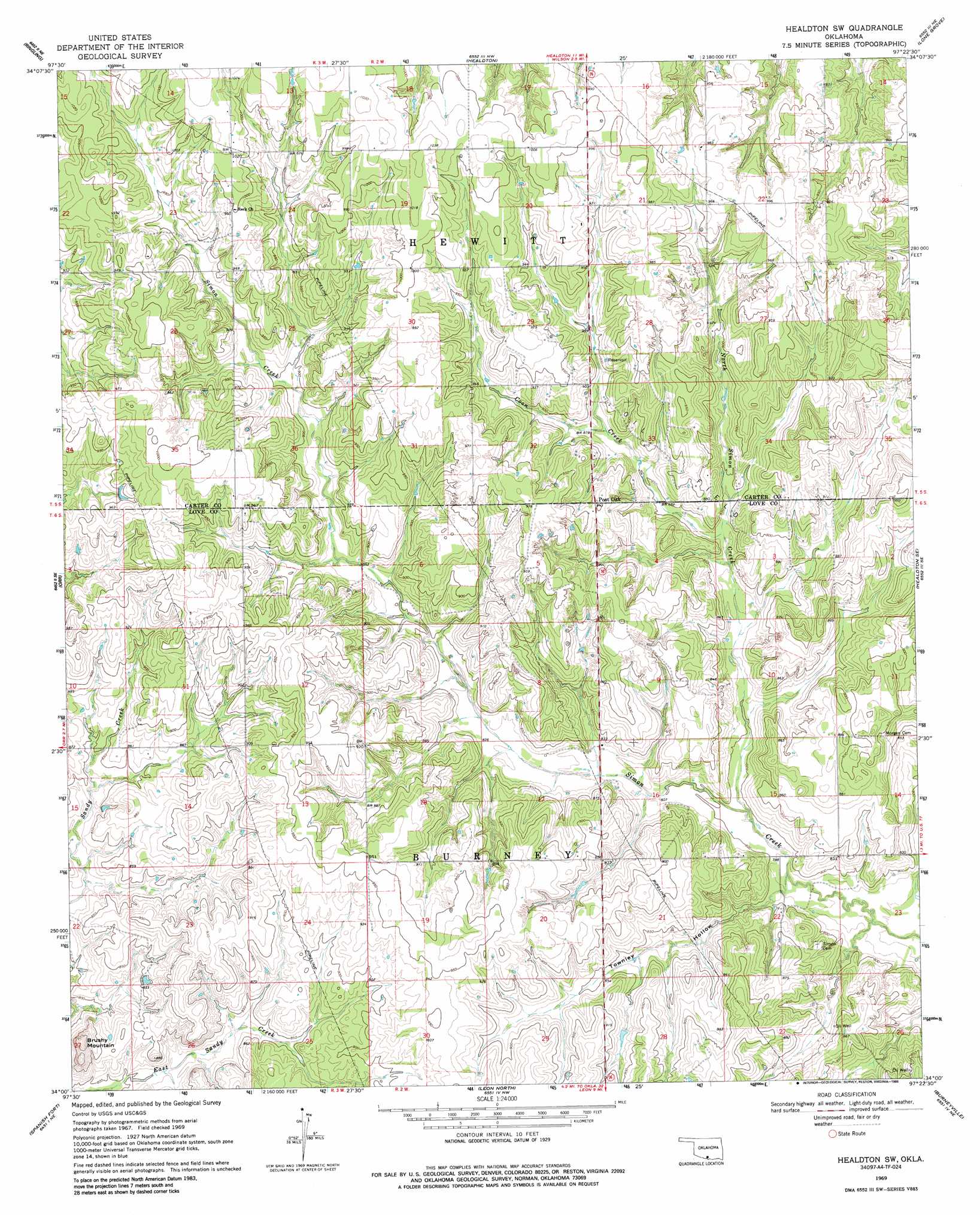
Healdton Sw Topo Map Oklahoma
To zoom in, hover over the map of Healdton Sw
USGS Topo Quad 34097a4 - 1:24,000 scale
| Topo Map Name: | Healdton Sw |
| USGS Topo Quad ID: | 34097a4 |
| Print Size: | ca. 21 1/4" wide x 27" high |
| Southeast Coordinates: | 34° N latitude / 97.375° W longitude |
| Map Center Coordinates: | 34.0625° N latitude / 97.4375° W longitude |
| U.S. State: | OK |
| Filename: | o34097a4.jpg |
| Download Map JPG Image: | Healdton Sw topo map 1:24,000 scale |
| Map Type: | Topographic |
| Topo Series: | 7.5´ |
| Map Scale: | 1:24,000 |
| Source of Map Images: | United States Geological Survey (USGS) |
| Alternate Map Versions: |
Healdton SW OK 1969, updated 1971 Download PDF Buy paper map Healdton SW OK 1969, updated 1986 Download PDF Buy paper map Healdton SW OK 2010 Download PDF Buy paper map Healdton SW OK 2012 Download PDF Buy paper map Healdton SW OK 2016 Download PDF Buy paper map |
1:24,000 Topo Quads surrounding Healdton Sw
Loco |
Cottonwood Creek |
Fox |
Milo |
Springer |
Ringling Nw |
Ringling |
Healdton |
Lone Grove |
Ardmore West |
Grady |
Orr |
Healdton Sw |
Healdton Se |
Overbrook |
Prairie Valley School |
Spanish Fort |
Leon North |
Burneyville |
Marietta West |
Nocona |
Bonita |
Leon South |
Marysville |
Thackerville |
> Back to 34097a1 at 1:100,000 scale
> Back to 34096a1 at 1:250,000 scale
> Back to U.S. Topo Maps home
Healdton Sw topo map: Gazetteer
Healdton Sw: Dams
Lower Bayou Creek Site 13 Dam elevation 245m 803′Lower Bayou Creek Site 14 Dam elevation 243m 797′
Lower Bayou Creek Site 15 Dam elevation 238m 780′
Lower Bayou Site Number 15 Dam elevation 242m 793′
Oknoname 085007 Dam elevation 266m 872′
Oknoname 085008 Dam elevation 272m 892′
Healdton Sw: Populated Places
Post Oak elevation 288m 944′Reck (historical) elevation 303m 994′
Healdton Sw: Reservoirs
Lower Bayou Creek Site 13 Reservoir elevation 245m 803′Lower Bayou Creek Site 14 Reservoir elevation 243m 797′
Lower Bayou Creek Site 15 Reservoir elevation 238m 780′
Lower Bayou Site Number 15 Reservoir elevation 242m 793′
Oknoname 085007 Reservoir elevation 266m 872′
Oknoname 085008 Reservoir elevation 272m 892′
Healdton Sw: Streams
Coon Creek elevation 253m 830′North Simon Creek elevation 240m 787′
Healdton Sw: Summits
Brushy Mountain elevation 287m 941′Healdton Sw: Valleys
Townley Hollow elevation 239m 784′Healdton Sw digital topo map on disk
Buy this Healdton Sw topo map showing relief, roads, GPS coordinates and other geographical features, as a high-resolution digital map file on DVD: