Limestone Canyon North Topo Map Arizona
To zoom in, hover over the map of Limestone Canyon North
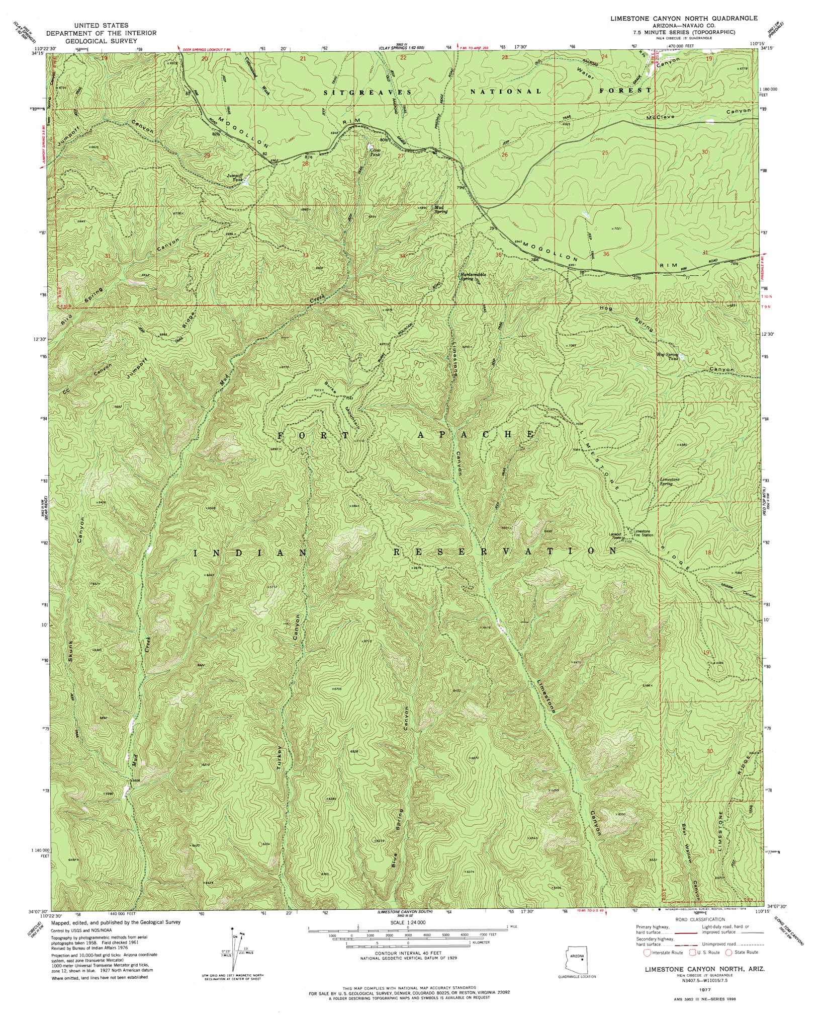
USGS Topo Quad 34110b3 - 1:24,000 scale
| Topo Map Name: | Limestone Canyon North |
| USGS Topo Quad ID: | 34110b3 |
| Print Size: | ca. 21 1/4" wide x 27" high |
| Southeast Coordinates: | 34.125° N latitude / 110.25° W longitude |
| Map Center Coordinates: | 34.1875° N latitude / 110.3125° W longitude |
| U.S. State: | AZ |
| Filename: | o34110b3.jpg |
| Download Map JPG Image: | Limestone Canyon North topo map 1:24,000 scale |
| Map Type: | Topographic |
| Topo Series: | 7.5´ |
| Map Scale: | 1:24,000 |
| Source of Map Images: | United States Geological Survey (USGS) |
| Alternate Map Versions: |
Limestone Canyon North AZ 1977, updated 1978 Download PDF Buy paper map Limestone Canyon North AZ 1998, updated 2000 Download PDF Buy paper map Limestone Canyon North AZ 2011 Download PDF Buy paper map Limestone Canyon North AZ 2014 Download PDF Buy paper map |
| FStopo: | US Forest Service topo Limestone Canyon North is available: Download FStopo PDF Download FStopo TIF |
1:24,000 Topo Quads surrounding Limestone Canyon North
Heber |
Aripine |
Big Pug Tank |
Cactus Flat |
Taylor |
Outlaw Draw |
Day Spring |
Clay Springs |
Pinedale |
Show Low North |
Pepper Canyon |
Bear Ridge |
Limestone Canyon North |
Red Top Mountain |
Show Low South |
Spotted Mountain |
Cibecue |
Limestone Canyon South |
Long Tom Canyon |
Faught Ridge |
Blue House Mountain |
Cibecue Peak |
Carrizo |
Cedar Creek |
Round Top Mountain |
> Back to 34110a1 at 1:100,000 scale
> Back to 34110a1 at 1:250,000 scale
> Back to U.S. Topo Maps home
Limestone Canyon North topo map: Gazetteer
Limestone Canyon North: Reservoirs
Clino Tank elevation 2071m 6794′Fill Tank elevation 2110m 6922′
Grade Tank elevation 2126m 6975′
Hog Spring Tank elevation 2009m 6591′
Jumpoff Tank elevation 2084m 6837′
McCleve Tank elevation 2071m 6794′
Limestone Canyon North: Ridges
Jumpoff Ridge elevation 2079m 6820′Limestone Canyon North: Springs
Hardscrabble Spring elevation 2061m 6761′Limestone Spring elevation 2098m 6883′
Mud Spring elevation 2069m 6788′
Limestone Canyon North: Summits
Burke Mountain elevation 2163m 7096′Limestone Canyon North: Valleys
Right Fork Water Canyon elevation 2037m 6683′Skunk Canyon elevation 1708m 5603′
Steer Spring Canyon elevation 1992m 6535′
Limestone Canyon North digital topo map on disk
Buy this Limestone Canyon North topo map showing relief, roads, GPS coordinates and other geographical features, as a high-resolution digital map file on DVD: