Taylor Topo Map Arizona
To zoom in, hover over the map of Taylor
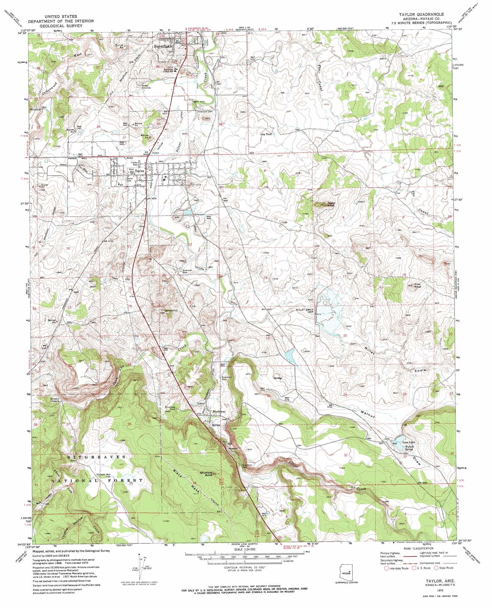
USGS Topo Quad 34110d1 - 1:24,000 scale
| Topo Map Name: | Taylor |
| USGS Topo Quad ID: | 34110d1 |
| Print Size: | ca. 21 1/4" wide x 27" high |
| Southeast Coordinates: | 34.375° N latitude / 110° W longitude |
| Map Center Coordinates: | 34.4375° N latitude / 110.0625° W longitude |
| U.S. State: | AZ |
| Filename: | o34110d1.jpg |
| Download Map JPG Image: | Taylor topo map 1:24,000 scale |
| Map Type: | Topographic |
| Topo Series: | 7.5´ |
| Map Scale: | 1:24,000 |
| Source of Map Images: | United States Geological Survey (USGS) |
| Alternate Map Versions: |
Taylor AZ 1970, updated 1973 Download PDF Buy paper map Taylor AZ 1998, updated 2000 Download PDF Buy paper map Taylor AZ 2011 Download PDF Buy paper map Taylor AZ 2014 Download PDF Buy paper map |
| FStopo: | US Forest Service topo Taylor is available: Download FStopo PDF Download FStopo TIF |
1:24,000 Topo Quads surrounding Taylor
Dry Lake Ne |
Flattop Hill |
Tenmile Cedars |
Hay Hollow |
Little Milky Wash |
Sheepskin Wash |
Second Knolls |
Snowflake |
Point Of The Mountain |
Manuel Seep |
Big Pug Tank |
Cactus Flat |
Taylor |
Mesa Redonda Nw |
Mesa Redonda |
Clay Springs |
Pinedale |
Show Low North |
Silver Springs |
Ortega Mountain |
Limestone Canyon North |
Red Top Mountain |
Show Low South |
Lakeside |
Sponseller Mountain |
> Back to 34110a1 at 1:100,000 scale
> Back to 34110a1 at 1:250,000 scale
> Back to U.S. Topo Maps home
Taylor topo map: Gazetteer
Taylor: Airports
Taylor Airport elevation 1751m 5744′Taylor: Bridges
Show Low Creek Bridge elevation 1729m 5672′Taylor: Canals
East Taylor Ditch elevation 1721m 5646′West Shumway Ditch elevation 1737m 5698′
West Taylor Ditch elevation 1714m 5623′
Taylor: Dams
Millet Swale Dam elevation 1742m 5715′Taylor: Lakes
Big Dry Lake elevation 1801m 5908′Taylor: Populated Places
Schoens Crossing elevation 1744m 5721′Shumway elevation 1736m 5695′
Taylor elevation 1717m 5633′
Taylor: Reservoirs
Bull Tank elevation 1754m 5754′Colbath Tank elevation 1801m 5908′
Jay Tank elevation 1723m 5652′
Love Lake elevation 1770m 5807′
Millet Swale Reservoir elevation 1742m 5715′
Schoens Lake elevation 1737m 5698′
Taylor: Springs
Walnut Spring elevation 1771m 5810′Taylor: Streams
Millet Swale elevation 1723m 5652′Show Low Creek elevation 1739m 5705′
Taylor: Summits
Black Mesa elevation 1864m 6115′Flint Knoll elevation 1817m 5961′
Shumway Butte elevation 1853m 6079′
Taylor Knoll elevation 1801m 5908′
Taylor: Valleys
Bull Hollow elevation 1753m 5751′Thistle Hollow elevation 1775m 5823′
Walnut Draw elevation 1726m 5662′
Taylor: Wells
Colbath Well elevation 1801m 5908′Park Well elevation 1721m 5646′
Taylor digital topo map on disk
Buy this Taylor topo map showing relief, roads, GPS coordinates and other geographical features, as a high-resolution digital map file on DVD: