Lake Montezuma Topo Map Arizona
To zoom in, hover over the map of Lake Montezuma
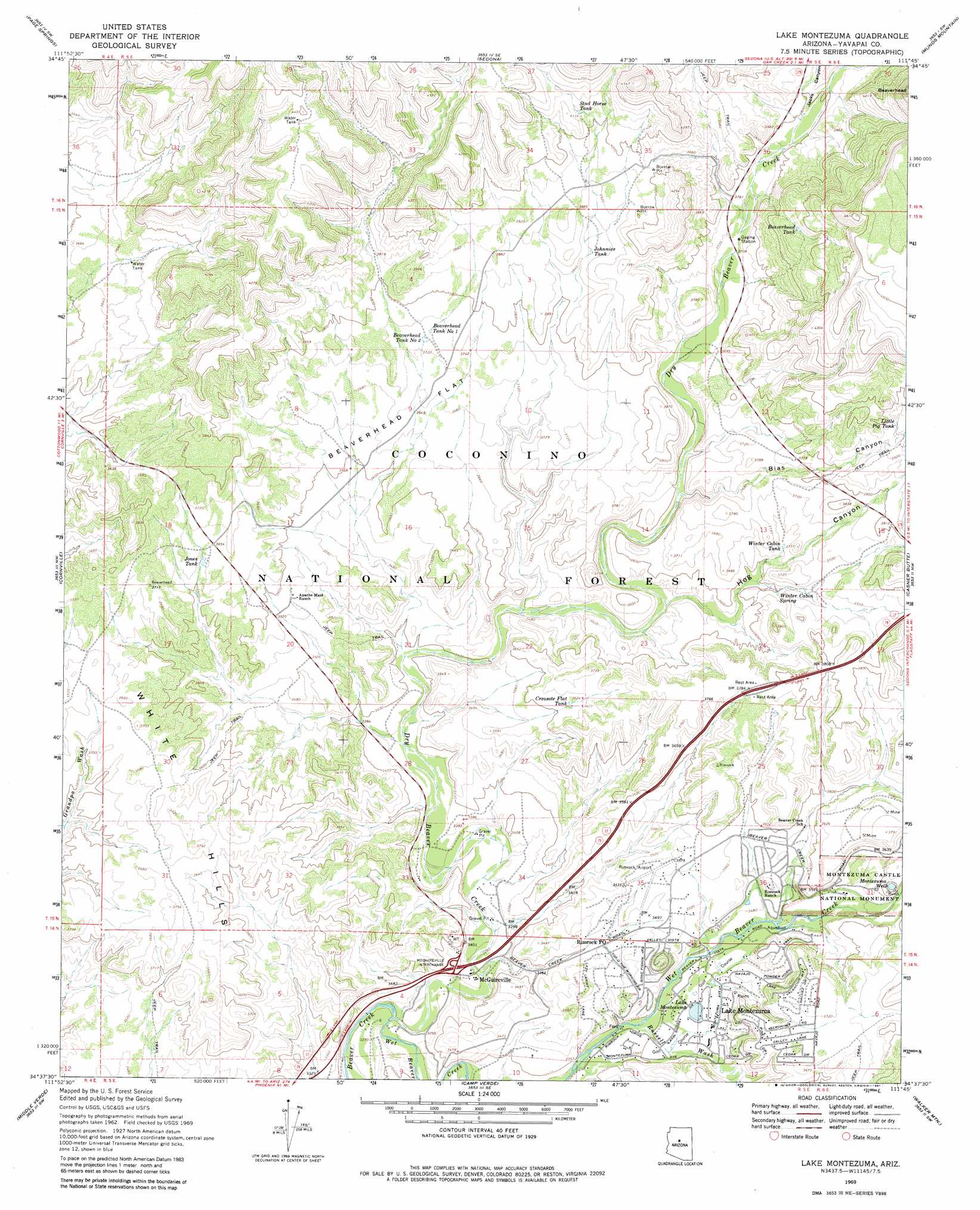
USGS Topo Quad 34111f7 - 1:24,000 scale
| Topo Map Name: | Lake Montezuma |
| USGS Topo Quad ID: | 34111f7 |
| Print Size: | ca. 21 1/4" wide x 27" high |
| Southeast Coordinates: | 34.625° N latitude / 111.75° W longitude |
| Map Center Coordinates: | 34.6875° N latitude / 111.8125° W longitude |
| U.S. State: | AZ |
| Filename: | o34111f7.jpg |
| Download Map JPG Image: | Lake Montezuma topo map 1:24,000 scale |
| Map Type: | Topographic |
| Topo Series: | 7.5´ |
| Map Scale: | 1:24,000 |
| Source of Map Images: | United States Geological Survey (USGS) |
| Alternate Map Versions: |
Lake Montezuma AZ 1969, updated 1972 Download PDF Buy paper map Lake Montezuma AZ 1969, updated 1981 Download PDF Buy paper map Lake Montezuma AZ 2011 Download PDF Buy paper map Lake Montezuma AZ 2014 Download PDF Buy paper map |
| FStopo: | US Forest Service topo Lake Montezuma is available: Download FStopo PDF Download FStopo TIF |
1:24,000 Topo Quads surrounding Lake Montezuma
Sycamore Basin |
Loy Butte |
Wilson Mountain |
Munds Park |
Mormon Mountain |
Clarkdale |
Page Springs |
Sedona |
Munds Mountain |
Stoneman Lake |
Cottonwood |
Cornville |
Lake Montezuma |
Casner Butte |
Apache Maid Mountain |
Cherry |
Middle Verde |
Camp Verde |
Walker Mountain |
Buckhorn Mountain |
Estler Peak |
Arnold Mesa |
Horner Mountain |
Hackberry Mountain |
Strawberry |
> Back to 34111e1 at 1:100,000 scale
> Back to 34110a1 at 1:250,000 scale
> Back to U.S. Topo Maps home
Lake Montezuma topo map: Gazetteer
Lake Montezuma: Airports
Rimrock Airport elevation 1084m 3556′Lake Montezuma: Cliffs
Beaverhead elevation 1365m 4478′Lake Montezuma: Crossings
McGuireville Interchange elevation 1023m 3356′Lake Montezuma: Flats
Beaverhead Flat elevation 1116m 3661′Lake Montezuma: Forests
Red Rock Ranger District elevation 1061m 3480′Lake Montezuma: Lakes
Lake Montezuma elevation 1046m 3431′Lake Montezuma: Parks
Montezuma Castle National Monument elevation 1087m 3566′Lake Montezuma: Populated Places
Lake Montezuma elevation 1052m 3451′McGuireville elevation 1013m 3323′
Lake Montezuma: Post Offices
Lake Montezuma Post Office elevation 1058m 3471′Rimrock Post Office elevation 1047m 3435′
Lake Montezuma: Reservoirs
Beaverhead Tank elevation 1243m 4078′Beaverhead Tank Number One elevation 1143m 3750′
Beaverhead Tank Number Two elevation 1140m 3740′
Cornville Tank elevation 1096m 3595′
Creosote Flat Tank elevation 1105m 3625′
Eaton Tank elevation 1073m 3520′
Johnnies Tank elevation 1175m 3854′
Jones Tank elevation 1108m 3635′
Little Pig Tank elevation 1195m 3920′
Stud Horse Tank elevation 1233m 4045′
Trick Number Two Tank elevation 1330m 4363′
Winter Cabin Tank elevation 1112m 3648′
Lake Montezuma: Springs
Beaverhead Spring elevation 1109m 3638′Dry Beaver Spring elevation 1135m 3723′
Winter Cabin Spring elevation 1102m 3615′
Lake Montezuma: Streams
Dry Beaver Creek elevation 987m 3238′Russell Wash elevation 1030m 3379′
Wet Beaver Creek elevation 987m 3238′
Lake Montezuma: Summits
White Hills elevation 1143m 3750′Lake Montezuma: Valleys
Bias Canyon elevation 1090m 3576′Hog Canyon elevation 1061m 3480′
Jacks Canyon elevation 1155m 3789′
Lake Montezuma: Wells
Montezuma Well elevation 1085m 3559′Lake Montezuma digital topo map on disk
Buy this Lake Montezuma topo map showing relief, roads, GPS coordinates and other geographical features, as a high-resolution digital map file on DVD: