Yarnell Topo Map Arizona
To zoom in, hover over the map of Yarnell
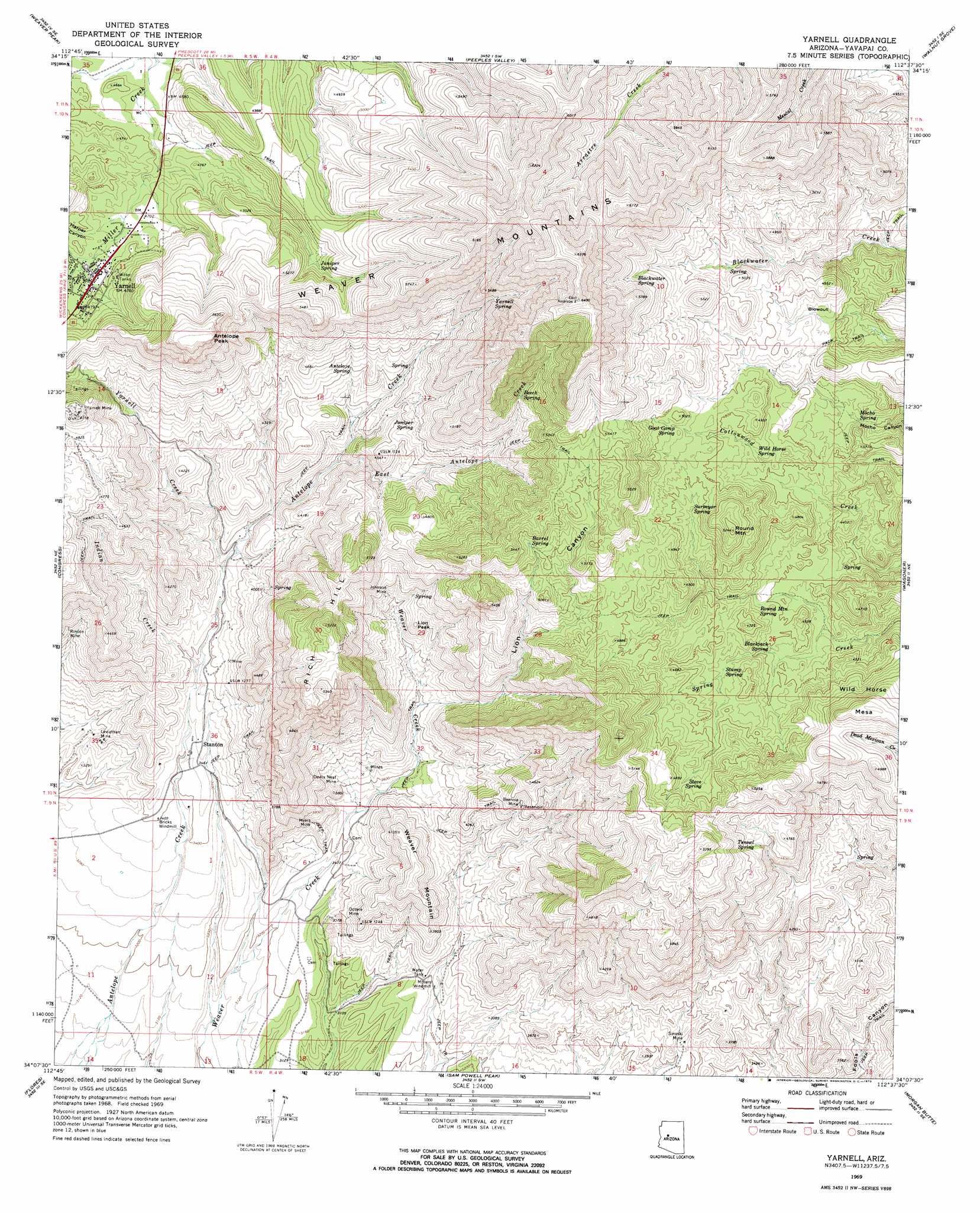
USGS Topo Quad 34112b6 - 1:24,000 scale
| Topo Map Name: | Yarnell |
| USGS Topo Quad ID: | 34112b6 |
| Print Size: | ca. 21 1/4" wide x 27" high |
| Southeast Coordinates: | 34.125° N latitude / 112.625° W longitude |
| Map Center Coordinates: | 34.1875° N latitude / 112.6875° W longitude |
| U.S. State: | AZ |
| Filename: | o34112b6.jpg |
| Download Map JPG Image: | Yarnell topo map 1:24,000 scale |
| Map Type: | Topographic |
| Topo Series: | 7.5´ |
| Map Scale: | 1:24,000 |
| Source of Map Images: | United States Geological Survey (USGS) |
| Alternate Map Versions: |
Yarnell AZ 1969, updated 1973 Download PDF Buy paper map Yarnell AZ 1969, updated 1973 Download PDF Buy paper map Yarnell AZ 2011 Download PDF Buy paper map Yarnell AZ 2014 Download PDF Buy paper map |
1:24,000 Topo Quads surrounding Yarnell
Hillside |
Bismarck Mesa |
Kirkland |
Wilhoit |
Groom Creek |
Date |
Weaver Peak |
Peeples Valley |
Walnut Grove |
Battleship Butte |
O'Neill Pass |
Congress |
Yarnell |
Wagoner |
Minnehaha |
Congress Sw |
Flores |
Sam Powell Peak |
Morgan Butte |
Copperopolis |
Outlaw Hill |
Vulture Peak |
Wickenburg |
Red Picacho |
Garfias Mountain |
> Back to 34112a1 at 1:100,000 scale
> Back to 34112a1 at 1:250,000 scale
> Back to U.S. Topo Maps home
Yarnell topo map: Gazetteer
Yarnell: Basins
Blowout elevation 1420m 4658′Yarnell: Mines
Beehive Mine elevation 1272m 4173′Devils Nest Mine elevation 1112m 3648′
Johnson Mine elevation 1301m 4268′
Leviathan Mine elevation 1012m 3320′
Myers Mine elevation 1092m 3582′
Octave Mine elevation 1049m 3441′
Sinoski Mine elevation 1054m 3458′
Yarnell Mine elevation 1545m 5068′
Yarnell: Populated Places
Octave elevation 1045m 3428′Stanton elevation 1066m 3497′
Yarnell elevation 1456m 4776′
Yarnell: Post Offices
Yarnell Post Office elevation 1461m 4793′Yarnell: Springs
Antelope Spring elevation 1345m 4412′Barrel Spring elevation 1547m 5075′
Beech Spring elevation 1543m 5062′
Blackjack Spring elevation 1338m 4389′
Blackwater Spring elevation 1621m 5318′
Goat Camp Spring elevation 1501m 4924′
Juniper Spring elevation 1375m 4511′
Juniper Spring elevation 1486m 4875′
Mocho Spring elevation 1351m 4432′
Round Mountain Spring elevation 0m 0′
Stove Spring elevation 1444m 4737′
Stump Spring elevation 1362m 4468′
Surveyor Spring elevation 1439m 4721′
Tunnel Spring elevation 1415m 4642′
Wild Horse Spring elevation 1425m 4675′
Yarnell Spring elevation 1562m 5124′
Yarnell: Streams
East Antelope Creek elevation 1207m 3959′Indian Creek elevation 1072m 3517′
Yarnell Creek elevation 1122m 3681′
Yarnell: Summits
Antelope Peak elevation 1760m 5774′Blowout Mountain elevation 1620m 5314′
Genung Mountain elevation 1417m 4648′
Lion Peak elevation 1346m 4416′
Rich Hill elevation 1629m 5344′
Round Mountain elevation 0m 0′
Weaver Mountain elevation 1259m 4130′
Wild Horse Mesa elevation 1563m 5127′
Yarnell: Valleys
Harper Canyon elevation 1435m 4708′Lion Canyon elevation 1153m 3782′
Yarnell: Wells
Carrol Well elevation 991m 3251′Yarnell digital topo map on disk
Buy this Yarnell topo map showing relief, roads, GPS coordinates and other geographical features, as a high-resolution digital map file on DVD: