Great Island Topo Map North Carolina
To zoom in, hover over the map of Great Island
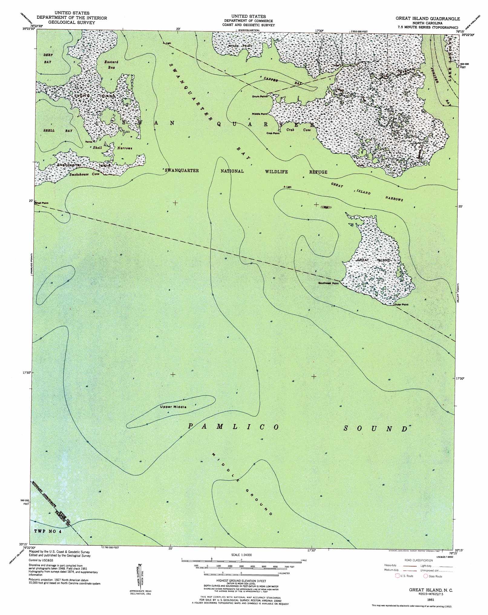
USGS Topo Quad 35076c3 - 1:24,000 scale
| Topo Map Name: | Great Island |
| USGS Topo Quad ID: | 35076c3 |
| Print Size: | ca. 21 1/4" wide x 27" high |
| Southeast Coordinates: | 35.25° N latitude / 76.25° W longitude |
| Map Center Coordinates: | 35.3125° N latitude / 76.3125° W longitude |
| U.S. State: | NC |
| Filename: | o35076c3.jpg |
| Download Map JPG Image: | Great Island topo map 1:24,000 scale |
| Map Type: | Topographic |
| Topo Series: | 7.5´ |
| Map Scale: | 1:24,000 |
| Source of Map Images: | United States Geological Survey (USGS) |
| Alternate Map Versions: |
Great Island NC 1951, updated 1952 Download PDF Buy paper map Great Island NC 1951, updated 1984 Download PDF Buy paper map Great Island NC 2002, updated 2002 Download PDF Buy paper map Great Island NC 2010 Download PDF Buy paper map Great Island NC 2013 Download PDF Buy paper map Great Island NC 2016 Download PDF Buy paper map |
1:24,000 Topo Quads surrounding Great Island
Belhaven |
Ponzer |
New Lake Se |
Fairfield |
Engelhard West |
Pamlico Beach |
Scranton |
Swanquarter |
New Holland |
|
Lowland |
Pamlico Point |
Great Island |
Bluff Point |
Middletown |
Jones Bay |
Little Fishing Point |
|||
Broad Creek |
Point Of Marsh |
North Bay |
Portsmouth |
> Back to 35076a1 at 1:100,000 scale
> Back to 35076a1 at 1:250,000 scale
> Back to U.S. Topo Maps home
Great Island topo map: Gazetteer
Great Island: Bars
Inner Middle elevation 0m 0′Middle Ground elevation 0m 0′
Upper Middle elevation 0m 0′
Great Island: Bays
Caffee Bay elevation 0m 0′Crab Cove elevation 0m 0′
Eastard Bay elevation 0m 0′
Juniper Bay elevation 0m 0′
Smokehouse Cove elevation 0m 0′
Swanquarter Bay elevation 0m 0′
Great Island: Capes
Crab Point elevation 0m 0′Drum Point elevation 0m 0′
Middle Point elevation 0m 0′
Outer Point elevation 0m 0′
Shell Point elevation 0m 0′
Southwest Point elevation 0m 0′
Great Island: Channels
Great Island Narrows elevation 0m 0′Shell Narrows elevation 0m 0′
Great Island: Guts
Old Haulover elevation 1m 3′Great Island: Islands
Great Island elevation 0m 0′Marsh Island elevation 1m 3′
Swanquarter Island elevation 0m 0′
Great Island: Parks
Swanquarter National Wildlife Refuge elevation 0m 0′Great Island: Streams
Island Creek elevation 0m 0′Raccoon Creek elevation 0m 0′
Great Island digital topo map on disk
Buy this Great Island topo map showing relief, roads, GPS coordinates and other geographical features, as a high-resolution digital map file on DVD:
Atlantic Coast (NY, NJ, PA, DE, MD, VA, NC)
Buy digital topo maps: Atlantic Coast (NY, NJ, PA, DE, MD, VA, NC)
 map DVD")